GRAVÜR DÜNYASI
Digital Engraving Library
| Artist | Heinrich Theodor Menke (1819-1892) |
| Date | 1866 |
| Technique | Copper Engraving-Original Hand Colored |
| Category | Maps |
| Source | Orbis antiqui descriptio [cartographic material] : an atlas illustrating ancient history and geography by eighteen maps by Heinrich Theodor Menke - Published by Justus Perthes, Gotha |
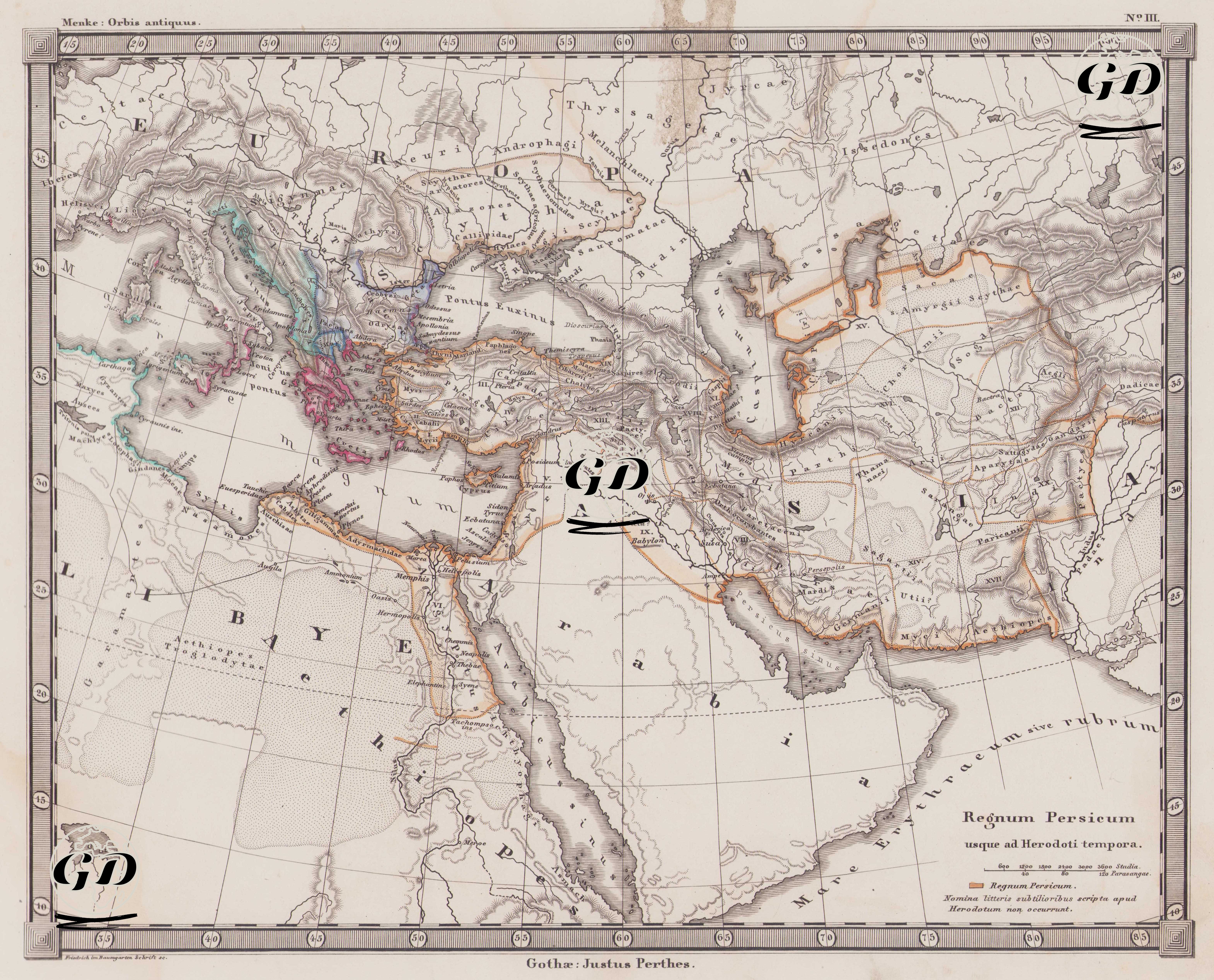
This map is map number III of the Orbis Antiquus atlas series in Justus Perthes's classical ancient geography series and its header is "Regnum Persicum usque ad Herodoti tempora", meaning "The Persian Empire until the time of Herodotus". The map documents in detail the borders of the Persian (Achaemenid) Empire in the mid-5th century BC, particularly during the time when the historian Herodotus (born around 484 BC in Halicarnassus - present-day Bodrum, Turkey - and probably died around 425 BC) lived and wrote. During this period, the Achaemenids had one of the largest empires in history, and their territory stretched from Thrace and Egypt in the west to the Hindu Kush Mountains in the east. The large area surrounded by orange lines on the map shows the lands under the direct administration of the Persian Empire. These borders are; It started from the Ionian cities on the western coast of Anatolia and spread to Thrace, Mesopotamia, Egypt, the Levant (Phoenicia, Palestine), northern Arabia, the Iranian plateau, Central Asia and today's Afghanistan and Pakistan. This region was also connected by royal roads, satrapies (provinces), and trade lines built by great Persian kings such as Darius and Xerxes I. The map, with its phrase "Herodoti tempora," claims to accurately convey this political organization as described by Herodotus. Another striking element on the map is the distinct cultural and ethnic clusters depicted by colored areas. These colored areas represent ancient Greek colonies (especially pink), Phoenician settlements (blue and green), areas of Egyptian influence, and regions home to ancient Mesopotamian civilizations. For example, Ionian cities such as Ephesus, Miletus, and Smyrna in western Anatolia are depicted as colonies of the Greek world. Similarly, Phoenician colonies in the western Mediterranean (such as Carthage) and cities along the Nile Valley in Egypt (Thebes and Memphis) are marked on the map. These details demonstrate the multilayered cultural fabric of the vast region under Persian rule. The map's cartographic structure depicts mountain ranges, river courses, and ancient cities from the classical period in detail, while utilizing the shading technique (hachure) to emphasize geographical features. The ancient world's most important waterways, such as the Nile, Euphrates, and Tigris, are meticulously depicted, visually conveying the importance of these arteries, particularly in terms of trade, agriculture, and communication. Furthermore, the geographical expansion of Persia, centered on the map with the phrase "Regnum Persicum," reveals the East-centric political order of pre-Roman antiquity. The geographical context of the events recounted by Herodotus in his "Histories" becomes clearly visible through this map.