GRAVÜR DÜNYASI
Digital Engraving Library
| Artist | Heinrich Theodor Menke (1819-1892) |
| Date | 1866 |
| Technique | Copper Engraving-Original Hand Colored |
| Category | Maps |
| Source | Orbis antiqui descriptio [cartographic material] : an atlas illustrating ancient history and geography by eighteen maps by Heinrich Theodor Menke - Published by Justus Perthes, Gotha |
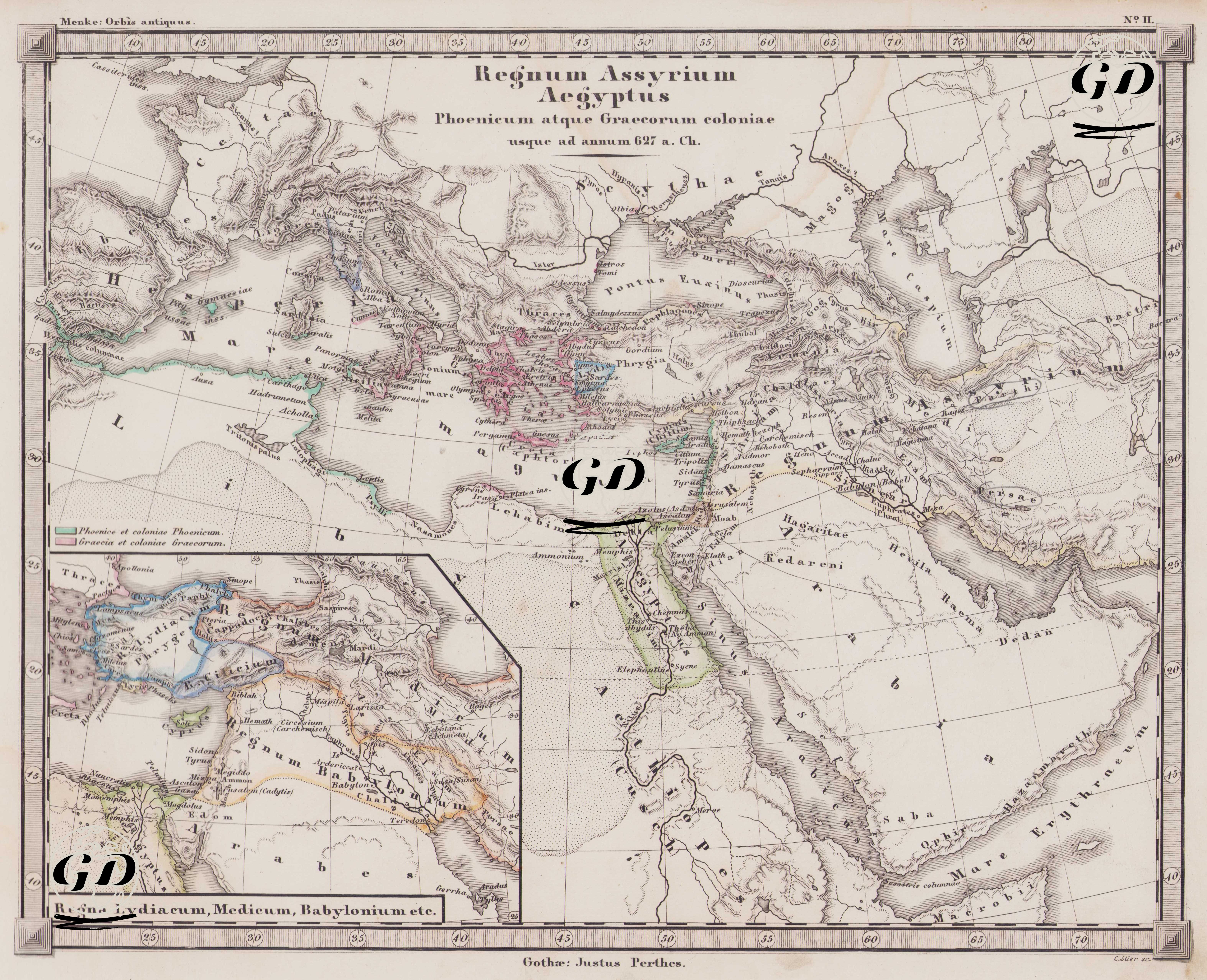
This map is number II in the Orbis Antiquus (Ancient World) atlas series published by Justus Perthes. Its title is "Regnum Assyrium, Aegyptus, Phoenicum atque Graecorum coloniae usque ad annum 627 a. Ch." This title means "Assyria, Egypt, Phoenicia, and Greek colonies until 627 BC" in Latin. The map covers the early 7th century BC, the peak of the Assyrian Empire and the period shortly before its collapse by the Medo-Babylonian coalition. The 26th Dynasty of Egypt, the Phoenicians' colonization of the Mediterranean coast, and the expansion of the Greek world to the West and Southern Italy are also discussed within this cartographic framework. One of the most striking aspects of the map is that the colored areas represent ancient colonial settlements. According to the legend: Green areas represent the colonies of the Phoenician peoples. These colonies, particularly those from the Levant coast to North Africa, Sicily, and southern Spain, included Carthago and Cádiz. Pink areas indicate Greek colonial territories. Many settlements in Western Anatolia, the Aegean Islands, Southern Italy (Magna Graecia), Thrace, and the Black Sea coast were the product of this wave of colonization. Smyrna, Miletus, Ephesus, Massalia (Marseille), and Byzantium (the ancient name of Istanbul) are prime examples of this colonial network. The map depicts not only colonial territories but also major empires. The Assyrian Empire (Regnum Assyrium) is depicted as centered in Mesopotamia and detailed with capitals and strategic cities such as Nineveh, Assur, and Kalhu. The map also shows Egypt's political boundaries, the division between Upper and Lower Egypt, and depicts ancient cities along the Nile Valley, particularly Memphis, Thebes, and Sais. In the south, Egyptian influence extending into Nubia is shown. There is also an inset map (small additional map) in the lower left corner of the map, which details the Lydian, Median and Babylonian Kingdoms. This inset reveals the centers of power operating in Mesopotamia and the Iranian Plateau in the 7th century BC—especially capitals such as Babylon, Ecbatana, and Susa—and reveals the geopolitical structure of the Eastern world. The inset also traces routes, ancient trade networks, and expedition routes between the eastern Mediterranean and the Euphrates-Tigris basin.