GRAVÜR DÜNYASI
Digital Engraving Library
| Artist | Heinrich Theodor Menke (1819-1892) |
| Engraver | Carl Stier |
| Date | 1866 |
| Technique | Copper Engraving-Original Hand Colored |
| Category | Maps |
| Source | Orbis antiqui descriptio [cartographic material] : an atlas illustrating ancient history and geography by eighteen maps by Heinrich Theodor Menke - Published by Justus Perthes, Gotha |
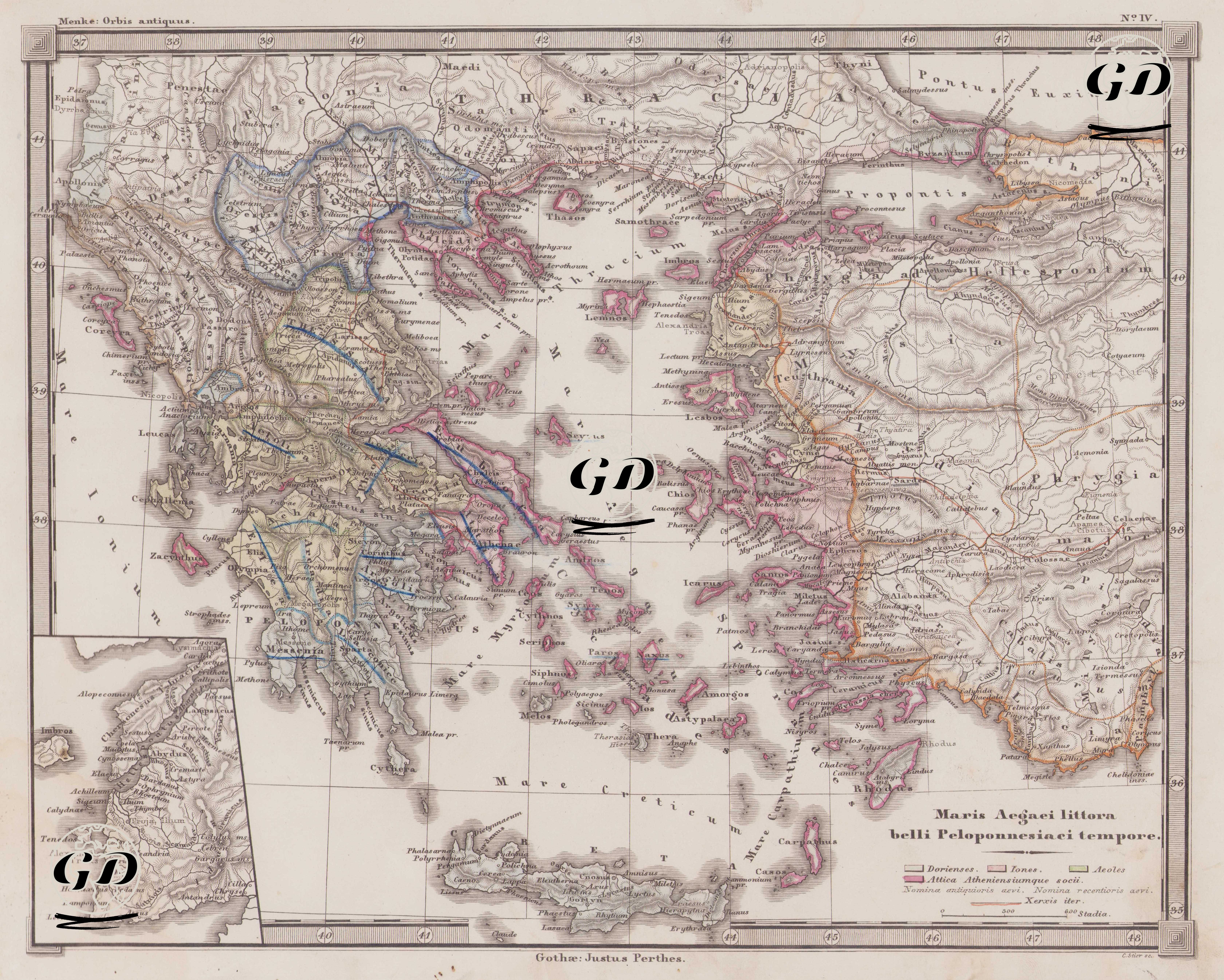
This map is number four in the Orbis Antiquus (Ancient World) atlas series published by Justus Perthes. It bears the title "Maris Aegaei litora belli Peloponnesiaci tempore," which in Latin means "the shores of the Aegean Sea during the Peloponnesian War." The map reflects the political and geographical conditions of the Peloponnesian War, a period fought between Athens (Delos League) and Sparta (Peloponnesian League), the two superpowers of the ancient Greek world, between 431 and 404 BC. This war profoundly influenced the fate of all Greek city-states, the balance of power in the Eastern Mediterranean, and the course of classical Greek civilization. This cartographically detailed map encompasses a vast region, from Thrace and the Propontis (Sea of Marmara) in the north, to the western coast of Anatolia in the east, to the island of Crete in the south, and to the Ionian coast in the west. The center of the map is the Aegean Sea and its surrounding islands, city-states, and coastal areas. The legend at the bottom of the map shows the Dorians (Dorienses), Ionians (Iones), Aeoles and the allies of Attica and Athens (Attica Atheniensiumque socii). Important Greek cities and islands, such as Athens (Athenae), Sparta (Lacedaemon), Corinth, Delos, Rhodes, Ephesus, Pergamon, and Smyrna, are clearly marked on the map. The regions of Aeolis, Ionia, and Caria along the Anatolian coast are shown in detail, while the strategic locations of the Aegean Islands are also meticulously illustrated. The Sea of Marmara is called the "Propontis," and the Black Sea its classical name, "Pontus Euxinus." Ancient sea routes and intercity routes are also indicated. An inset map of the Dardanelles is located in the lower left corner of the map.