GRAVÜR DÜNYASI
Digital Engraving Library
| Artist | Heinrich Theodor Menke (1819-1892) |
| Date | 1866 |
| Technique | Copper Engraving-Original Hand Colored |
| Category | Maps |
| Source | Orbis antiqui descriptio [cartographic material] : an atlas illustrating ancient history and geography by eighteen maps by Heinrich Theodor Menke - Published by Justus Perthes, Gotha |
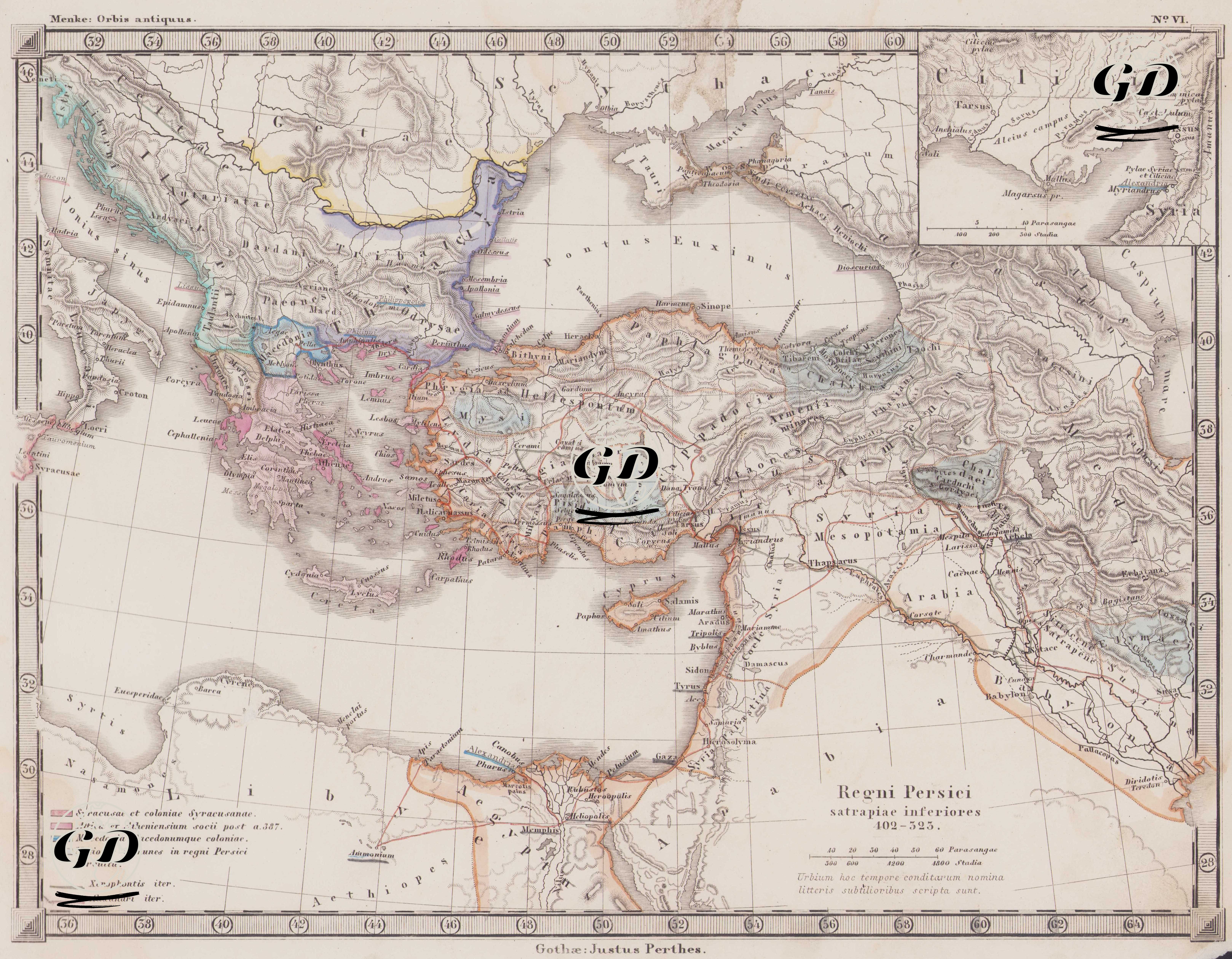
This map, number VI of the Orbis Antiquus (Ancient World) series published by Justus Perthes, depicts the sub-satrapies of the Persian Empire between 402 and 325 BC, as defined in its title by the phrase "Regni Persici satrapiae inferiores 402–325." This map, drawn in exceptional cartographic detail, presents the final phase of the Achaemenid period, particularly the period encompassing Alexander the Great's eastern campaigns. The map encompasses a vast area extending from the Balkans and Thrace in the west to the Iranian plateau in the east, the southern shores of the Black Sea in the north, and the Nile Delta, Palestine, Phoenicia, Mesopotamia, and the Persian Gulf in the south. The region is colored according to the satrapies under Achaemenid rule in the ancient world, and the boundaries of each satrapy are carefully delineated. In antiquity, the satrapy system referred to the governorship structure governing the provinces of the central Persian government. The linear density and topographic details of the map also show in detail the roads, cities, mountain ranges and river systems of that period. The legend in the lower left corner details the colored areas reflecting the political and ethnic structures of the period: 1. Syracuse et coloniae Syracusanae (Red): Represents the city of Syracuse and its colonies. These colonies are particularly visible in areas near the coasts of Western Anatolia. 2. Attica et Atheniensium socii post a. 387 (Pink): Attica and its allies after 387 BC are shown in this color. This period coincides with the time when Athens re-established a naval union. 3. Macedonia Macedonumque Coloniae (Blue): Indicates Macedonia and Macedonian colonies, particularly military or administrative centers established during the expansion of the Kingdom of Macedonia. These colonies would become even more widespread during Alexander's eastern campaign. 4. Nationes immunes in regni Persici circuitu (Light Blue): These groups were located on the periphery of the Persian Empire but were exempt from certain obligations (e.g., taxes or military contributions). These groups demonstrate the flexibility the Persian government granted to local autonomy. 5. Xenophontis Iter (dark gray line): It shows the route of the Return of the Ten Thousand, described by the Greek commander Xenophon in his work "Anabasis." This route represents the return route of the Greek mercenaries who participated in the struggle for the Persian throne in 401 BC. 6. Alexandri Iter (orange line): It is the campaign route of Alexander the Great. Starting from Macedonia and extending into Anatolia, Mesopotamia, and the interior of Iran, this route allows you to follow Alexander's eastward advance and the conquest of the Persian Empire on a map. The settlement names are based on ancient sources and written in Latin letters; topographic shading highlights mountainous areas, river valleys, and coastal features. The area surrounding Cilicia is shown as an inset in the upper right corner of the map. This map, which includes ancient centers such as Lower Mesopotamia, Babylon, Susa, and Persepolis, brings together important geographical centers for both Persian and Macedonian historiography. Likewise, port areas such as the Nile Delta, Alexandria, and the Phoenician coast are also shown in detail. This map serves as a primary visual resource for researchers studying ancient history, classical philology, military strategy, colonial geography, ancient routes, and trade networks. It enables the geographical analysis of texts such as Alexander the Great's Asiatic Campaign and Xenophon's Anabasis. By tracing the satrapy system on the map, the geographic structure of Achaemenid rule can be grasped. Therefore, this map is not only a document depicting ancient borders but also a scientific map that spatially represents the military-political, ethnic, and commercial structures of the classical era. It is particularly important for highlighting the central role of regions like Anatolia and Mesopotamia, which served as transition zones between different civilizatio