GRAVÜR DÜNYASI
Digital Engraving Library
| Artist | Heinrich Theodor Menke (1819-1892) |
| Engraver | W.Behrens |
| Date | 1866 |
| Technique | Copper Engraving-Original Hand Colored |
| Category | Maps |
| Source | Orbis antiqui descriptio [cartographic material] : an atlas illustrating ancient history and geography by eighteen maps by Heinrich Theodor Menke - Published by Justus Perthes, Gotha |
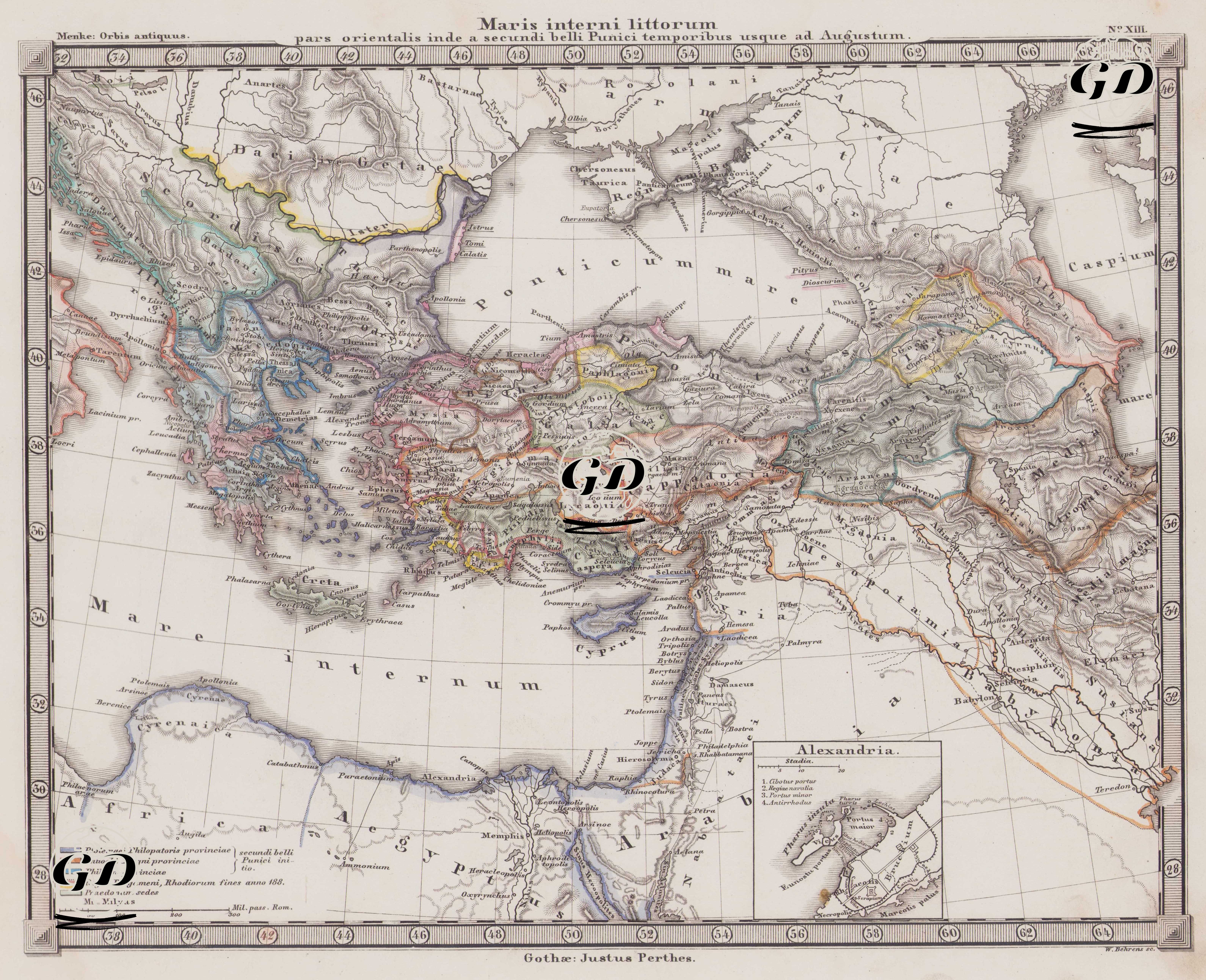
This map is a historical cartographic work prepared by the Justus Perthes publishing house and showing the geography of the classical period and bearing the Latin title: "Maris interni littorum pars orientalis inde a secundi belli Punici temporibus usque ad Augustum", in other words "The eastern shores of the Inland Sea (the Mediterranean), from the period of the Second Punic War to the reign of Augustus". The map focuses specifically on ancient Roman and Hellenistic geography and covers the period from the Second Punic War, which began in 218 BC (best known for Hannibal's famous Alpine crossing and the campaigns he led into the interior of Italy), to 27 BC, when Augustus was declared Roman Emperor. The era of Augustus, whose real name was Octavian, who was the adopted son of Julius Caesar, spans 27 BC - 14 AD. II. From the Punic War to the Age of Augustus refers to the period in which Rome transitioned from a regional republic to the dominant power in the Mediterranean world. In this context, the map reflects the state of the late Roman Republic and the Hellenistic kingdoms, both in terms of military and political expansion and provincial systems. The geographic coverage is quite extensive: in the west, the Adriatic coast and Greece; in the north, Thrace and northern Anatolia, extending to the Black Sea; in the east, the Caspian Sea, the Parthian Kingdom (Parthia), Media (Media), Assyria (Assyria), and Babylonia; and in the south, Palestine, Syria, and Egypt. The term "Mare Internum" refers to the Mediterranean Sea, "Mare Caspium" to the Caspian Sea, and important islands such as "Creta," "Cyprus," and "Rhodes" are also shown in detail. Colored border distinctions were used to identify different political units or administrative structures during historical periods. The legend below indicates the meanings of these colors: Green (Ptolemaei Philopatoris provinciae - provinces ruled by Ptolemy Philopator (probably Ptolemy IV) at the beginning of the Second Punic War), Orange (Antiochi Magni provinciae - provinces ruled by Magnus (Antiochus the Great) at the beginning of the Second Punic War), Blue (Philippi provinciae - provinces ruled by Philip at the beginning of the Second Punic War), Dotted Line (Regni Pergameni, Rhodiorum fines anno 188 - borders of the Kingdom of Pergamon and the Rhodians in 188 BC), Light Areas (Praedonum sedes - settlements of bandits/pirates). Along with the brown and red borders, the map also shows ancient roads, cities (Roman colonies and Hellenistic centers), river systems, and important ports. The small box in the lower right corner of the map details the ancient state of Alexandria. Structures such as the Pharos, the Great Library, the Museion, and port facilities are marked here. The map is particularly valuable for tracing Rome's eastern policy, the borders of the Hellenistic states (Seleucids, Ptolemies) and the Roman expansion in these regions.