GRAVÜR DÜNYASI
Digital Engraving Library
| Date | 1895 |
| Technique | Chromolithograph |
| Category | Maps |
| Source | Meyers Konversations-Lexikon, 6. Auflage - Bibliographisches Institut in Leipzig |
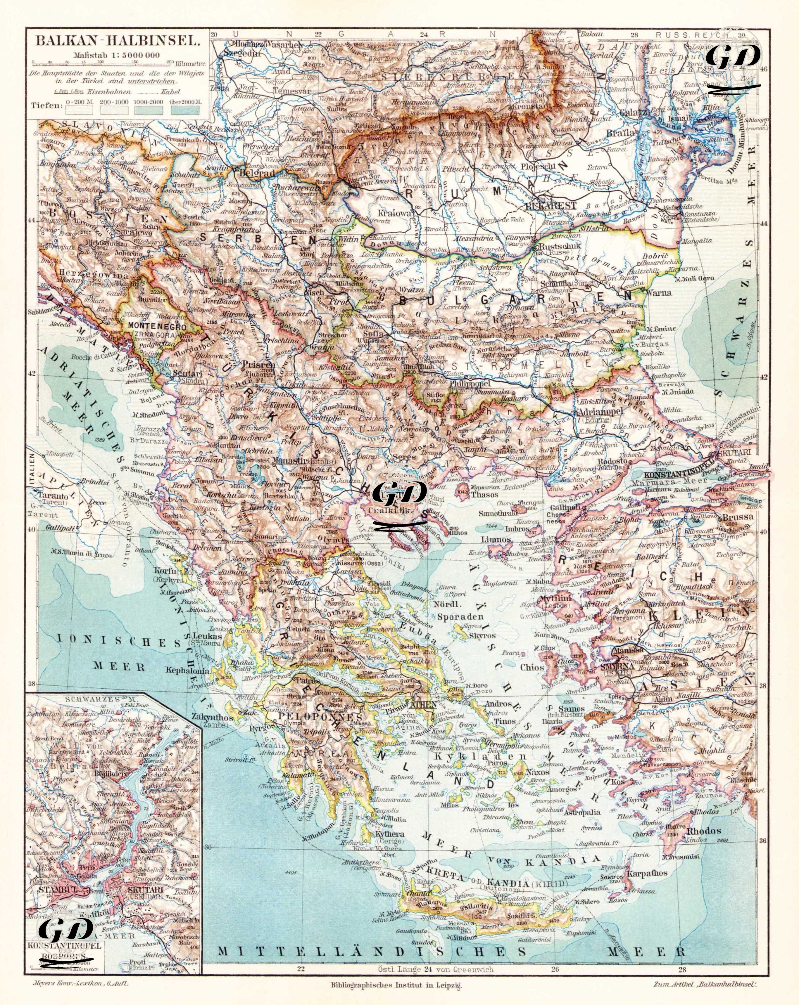
This map, titled "Balkan Halbinsel-Balkan Peninsula," is a political and geographical map depicting the political and geographical structure of Southeastern Europe. Published in German in the 6th edition of Meyers Konversations-Lexikon, the map reflects the updated borders and administrative structures of the Balkans, particularly after the 1878 Treaty of Berlin. The legend in the upper left corner of the map explains the colored relief method for sea depths and mountain heights; brown indicates elevations, and blue indicates sea depths. The area covered by the map extends from Hungary and the Carpathian Mountains in the north to Crete and the Mediterranean in the south, and from the Adriatic coast in the west to the western coast of Anatolia in the east. Political units in the Balkans, such as the Ottoman Empire, Serbia, Montenegro, Bulgaria, Romania, and Greece, are marked with different border lines; the distinction between Bulgaria, Eastern Rumelia, and Ottoman lands is particularly carefully illustrated. Istanbul and its surroundings are detailed with a larger-scale inset (small map) in the lower left corner of the map. This inset presents important centers, transportation routes, and geographical locations, such as the Bosphorus, the Golden Horn, Galata, Pera, and Üsküdar. Geographical names and labels on the map are based on the common German transliteration of the period; for example, Thessaloniki is "Saloniki" and Istanbul is "Konstantinopel." Furthermore, disputed territories along the Adriatic coast, such as the Albanian regions, the Kosovo Plain, Thessaly, and Macedonia, are carefully drawn to reflect Ottoman, Greek, and Serbian influences, thus highlighting political tensions of the period. The map, with meticulous topographic detail, depicts mountain ranges (e.g., the Balkan Mountains, the Pindos Mountains), river systems (the Danube, Morava, Vardar, Maritsa), lakes (Ohrid, Prespa), and passes, as well as transportation networks and strategic routes. Important cities, ports, and commercial centers are also marked in different typographic sizes according to their size. This map was prepared to provide both geographical information and document political borders, and it presents a functional example of orientalist cartography to help European public opinion understand the new balance of power in the Balkans after the Berlin Treaty.