GRAVÜR DÜNYASI
Digital Engraving Library
| Date | 1895 |
| Technique | Chromolithograph |
| Category | Maps |
| Source | Meyers Konversations-Lexikon, 6. Auflage - Bibliographisches Institut, Leipzig |
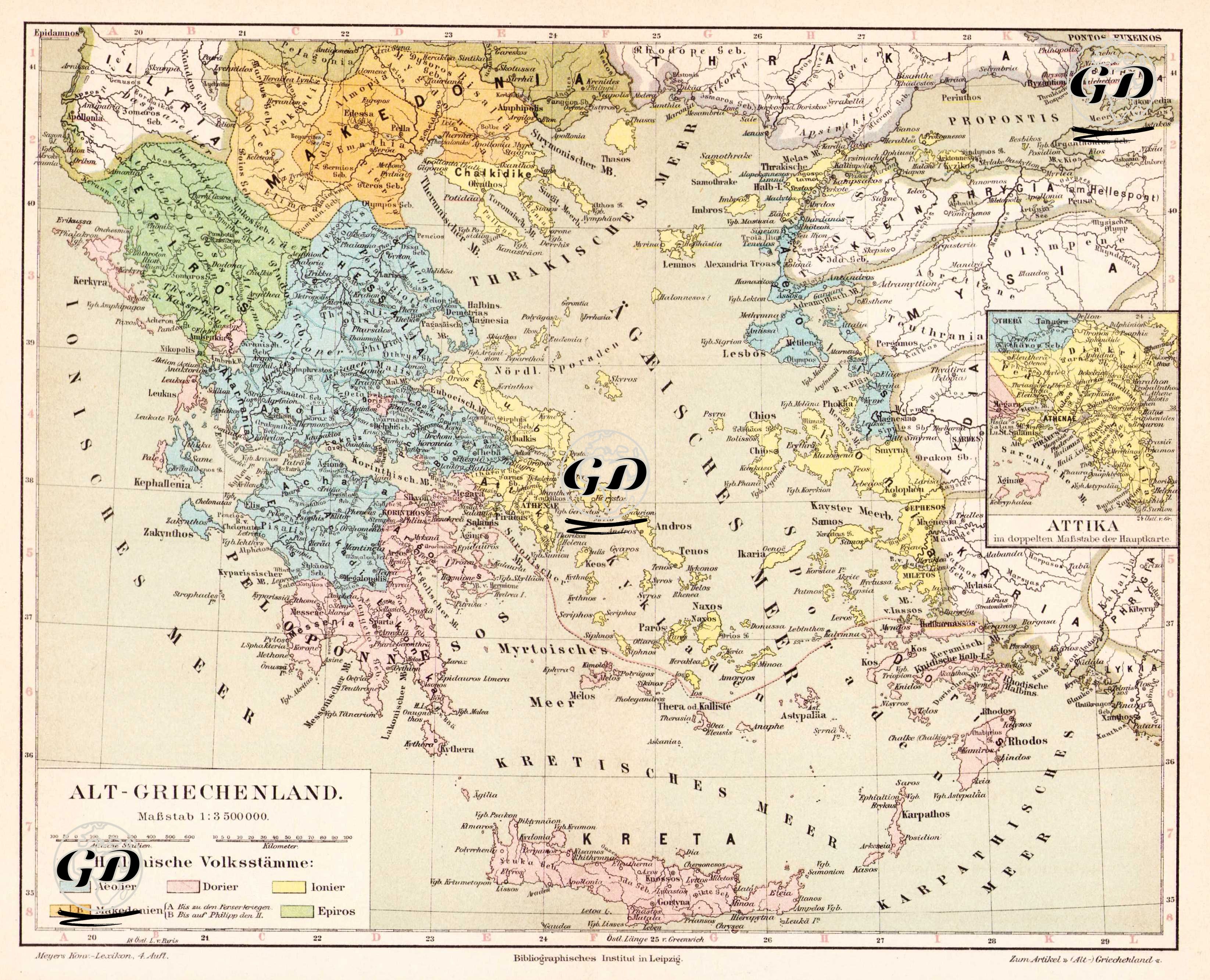
This map, titled "Alt-Griechenland" (Ancient Aegean Coast and Ancient Greece), is a highly detailed and scientific cartographic visual depicting the geographic, ethnic, and cultural distribution of the Hellenistic Greek world and the Ancient Greek Aegean Coast. It was prepared by the Bibliographisches Institut in Leipzig, one of Germany's leading publishing houses, in the 19th century and published in the sixth edition of Meyers Konversations-Lexikon. The legend in the lower left corner of the map identifies Hellenistic peoples (Hellenische Volksstämme) in different colors: Ionians in yellow, Dorians in blue, Aolians in green, Makedonians in orange, and the peoples of Epirus in light green. This color coding delineates not only cities but also the tribal or linguistic-ethnic groups that populated the region. The map is not limited to present-day Greece; it encompasses Thrace, Western Anatolia (Ionia), the Aegean Islands, Crete (Creta), Rhodes, and all of Western Anatolia. To the east, it also includes ancient Anatolian regions such as the Troad, Mysia, Lydia, Caria, and Pamphylia, visualizing the eastward spread of Greek colonization. Furthermore, an enlarged, detailed map of Attica is included in the upper right corner, highlighting the density of ancient settlements in and around Athens. The map is unique in depicting the geographic distribution of ethnolinguistic divisions in the ancient Greek world. The three main tribal families of the Greek world—Aiolians, Ionians, and Dorians—are presented not merely as philological or mythological classifications but as concrete geographical areas. The map shows Ephesus, Miletus, Smyrna, and Phocaea in Ionia; Sparta (Lakedaimon), Corinth, and Argos in the Peloponnese; Athens (Athenai) and the important ancient demes (Phyle and Dekeleia) in Attica; Ancient settlements such as Pella, Edessa, Amphipolis in Macedonia and Delos, Naxos, Paros, Chios, Lesbos in the Aegean islands are clearly marked. This map is not only a geographical document but also an example reflecting the 19th-century scholarly perspective on ancient ethnogeography. It is significant for its depiction of how ethnic identities were geographically situated and their distribution according to ethnological (tribal) origins. Meyers Konversations-Lexikon, in which this map was published, was one of the most respected and widely used encyclopedias in Germany, published from 1839 to 1984.