GRAVÜR DÜNYASI
Digital Engraving Library
| Date | 1878 |
| Technique | Lithography-Colored |
| Category | Maps |
| Source | The Collegiate Atlas - William Collins Sons & Co. Limited, Glasgow & London |
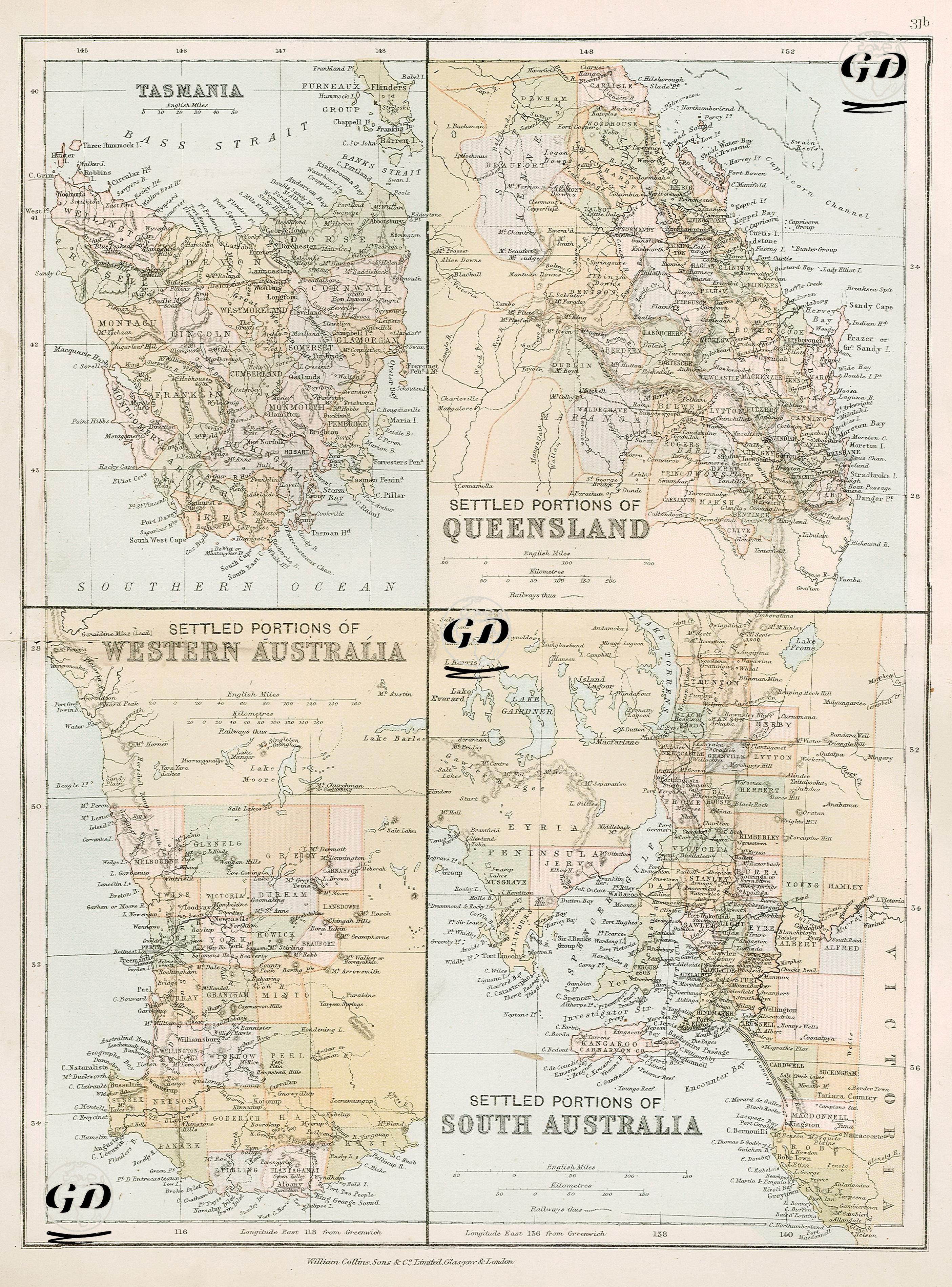
This map shows the areas where settlement was concentrated in four distinct regions of the Australian continent during the British colonial period, presenting the administrative, geographical, and colonial dynamics of the period. The page is designed into four small panels: Tasmania in the upper left, Queensland in the upper right, Western Australia in the lower left, and South Australia in the lower right. This arrangement allows for comparative analysis for the map reader and demonstrates how cartography represented British settlement and administrative policies in Australia in the second half of the 19th century. The map of Tasmania (formerly Van Diemen's Land) shows dense settlement along the island's coast. The settlement areas developed around two main centers, Hobart Town and Launceston, are prominent. Mountainous areas, forested areas, and river systems are depicted in detail. While Tasmania's southeastern and northeastern coasts appear particularly densely populated, the western part remains largely uninhabited. A map of Queensland reveals densely populated settlements along the east coast. Cities such as Brisbane, Rockhampton, and Maryborough stood out as ports and trading centers during this period, while inland pastoral areas were characterized by concentrated cattle-raising and agricultural activities. The western parts of Queensland, not yet open to European settlers, were designated as "settled areas." On the map of Western Australia, only the southwestern corner was opened to settlement. Cities such as Perth and Albany were identified as important centers of the colonial era. Inland, valleys and plains suitable for agriculture and animal husbandry were divided into administrative units. The colored areas on the map reflect how these settlements were divided into "counties" or "districts." The area surrounding the Swan River Colony has been mapped in particular detail. The map of South Australia centers on the colonial settlement centered around the city of Adelaide. It carefully depicts areas where economic activity was concentrated, such as railways, postal routes, ports, and agricultural lands. Geographical features such as the Yorke and Eyre peninsulas and Kangaroo Island are meticulously illustrated. Colored areas represent administrative divisions, while transportation lines provide economic access to these areas. The entire map is detailed in both geographic and administrative aspects, and settlements played a significant role in shaping modern Australia. All panels are in English miles, with the equivalent kilometers on the scale. Reflecting the colonial mindset of the period, the map bears the hallmarks of a typical 19th-century colonial map, depicting the interior, where Indigenous peoples lived, as "empty" or "unsettled."