GRAVÜR DÜNYASI
Digital Engraving Library
| Date | 1878 |
| Technique | Lithography-Colored |
| Category | Maps |
| Source | The Collegiate Atlas - William Collins Sons & Co. Limited, Glasgow & London |
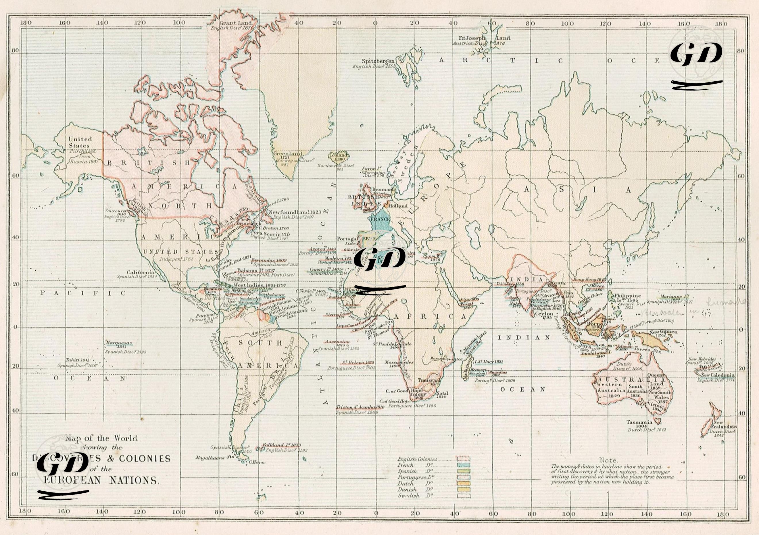
This map depicts the discoveries and colonies of European nations around the world. The map color-codes the regions where British, French, Dutch, Spanish, Portuguese, Danish, and Swedish explorers were influential, along with the dates and nations that discovered and controlled these regions. The legend in the lower right corner displays a different color code (e.g., red for the British, blue for the French, and green for the Portuguese) and descriptive symbols for each colonial power. The designations on the map not only identify the geographical regions but also indicate the year of discovery and the nation colonizing the region. For example, in the Americas, locations such as Newfoundland (1623, British), Florida (1512, Spanish), Guyana (1595, British), Brazil (1500, Portuguese), and the Bahamas (Lucayans) are labeled with both the date and the colonial power. On the African coast, points such as Ivory Coast, Gold Coast, and Sierra Leone are marked as Portuguese, British, or French colonies. In Asia, much of India was under British influence and designated "British India," while French and Portuguese settlements were shown as small regional areas. Colonization dates for places like Ceylon (Sri Lanka), Malacca, and Sumatra are also provided. Australia is designated "New Holland" and "New South Wales," while Tasmania's labeling as "Dutch 1642" marks the first Dutch explorations. This map documents not only geographical discoveries but also the geopolitical traces of imperial rivalry. From the 15th century onward, Europe's great powers not only explored the world but also translated these discoveries into economic exploitation and political domination, establishing a vast colonial network. The map also illustrates this expansion process and the interchange of colonized territories over time. For example, some regions may have been first discovered by one nation and later colonized by another; this is reflected in the dates and designations on the map. Additionally, the "Note" section on the map indicates that place names in lighter colors represent the first European discovery of the region, while those in bold indicate the nation that last held colonial rule. This transforms the map from a mere geographical tool to a narrative of colonial history.