GRAVÜR DÜNYASI
Digital Engraving Library
| Date | 1878 |
| Technique | Lithography-Colored |
| Category | Maps |
| Source | The Collegiate Atlas - William Collins Sons & Co. Limited, Glasgow & London |
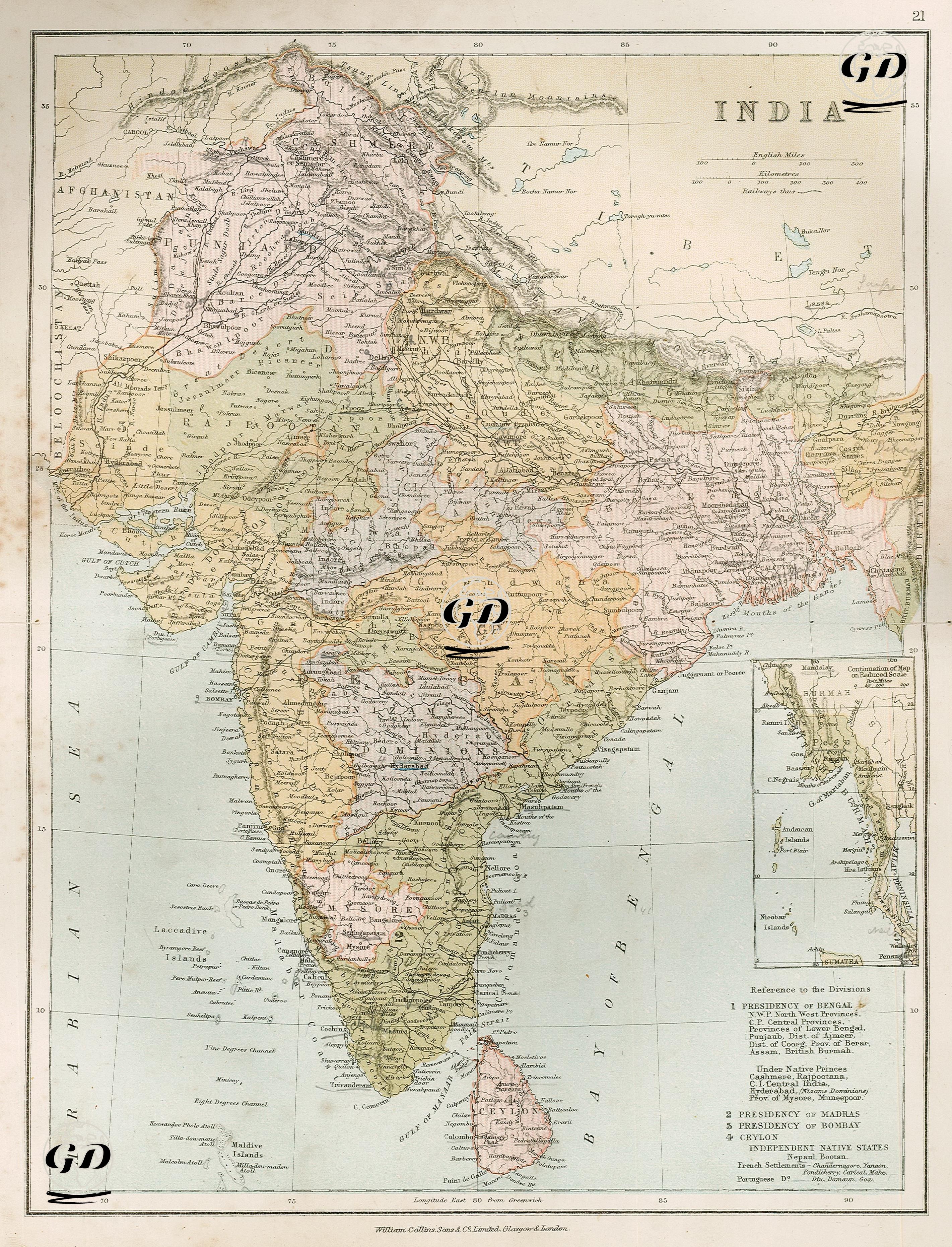
This 1878 map shows the administrative structure and colonial order of the British Empire in the Indian subcontinent. The legend in the lower right corner of the map shows the main regions into which this political geography was divided. Accordingly, there were four main classifications under British rule: 1) Bengal Presidency, 2) Madras Presidency, 3) Bombay Presidency, and 4) Ceylon. These presidencies represent the main territories under direct British rule and are clearly colored separately on the map. The Bengal Presidency encompassed a vast area including the Northwestern Provinces, the Central Provinces, the Lower Bengal Provinces, Punjab (Punjab), Ajmeer, Coorg, Berar, Assam, and parts of British Burmah (modern-day Myanmar). This vast region encompassed both northern and eastern India and also included the strategically important Burmah (modern-day Myanmar). The Bombay Presidency was located on the western coast, while the Madras Presidency in the southeast encompassed Tamil Nadu and its surrounding areas. The areas governed under local Principalities are also detailed. Regions such as Cashmere (Kashmir), Rajpootana (present-day Rajasthan), Central India, Hyderabad (the lands ruled by the Nizams), Mysore State, and Munneepoor (Manipur) were governed by semi-independent monarchical structures, declaring allegiance to Britain but enjoying internal autonomy. This structure was typical of the indirect rule system in India. Ceylon, encompassing modern-day Sri Lanka, was administered directly as a British colony. Additionally, some regions, such as Nepal and Bhutan, are designated as "Independent Native States" on the map; although these countries were not under British rule, they maintained a semi-independent status subject to British foreign policy. However, French and Portuguese settlements are also noted at the bottom of the map. French colonies include Chandernagore, Yanaon, Pondicherry, Carical, and Mahé, while Portuguese settlements are listed as Diu, Damaun, and Goa. This information demonstrates that, despite British rule, other European powers maintained a limited presence in India.