GRAVÜR DÜNYASI
Digital Engraving Library
| Date | 1878 |
| Technique | Lithography-Colored |
| Category | Maps |
| Source | The Collegiate Atlas - William Collins Sons & Co. Limited, Glasgow & London |
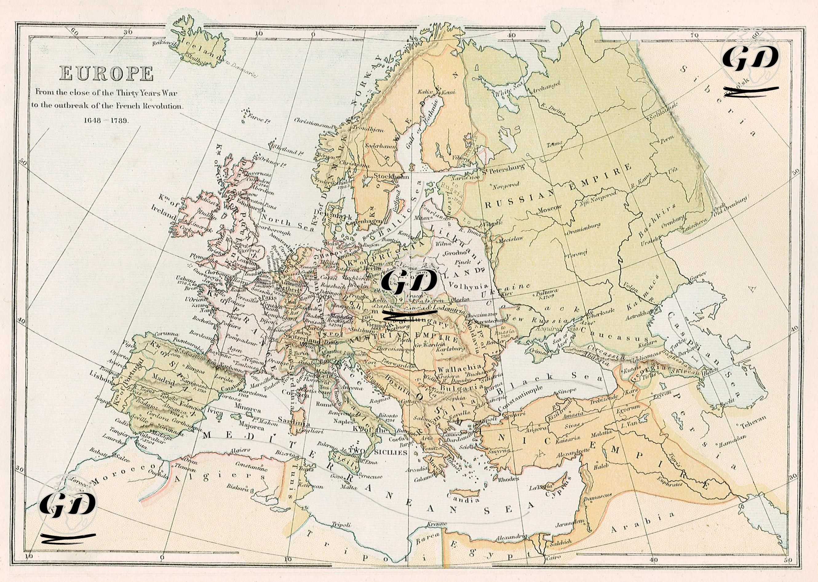
This map depicts Europe between 1648 and 1789, from the end of the Thirty Years' War to the beginning of the French Revolution. It reflects both the early modern European state system's emergence and the continental expansion and borders of major powers such as the Ottoman Empire, the Habsburgs, Russia, and France. At the center of the map, encompassing modern-day Germany and its surroundings, are numerous independent or semi-independent political units, reflecting the fragmented and confederative structure of the Holy Roman Empire of the period. While the term "Holy Roman Empire" is not directly included on the map, the numerous small states designated by names such as Saxony, Bavaria, Bohemia, Austria, Württemberg, Hesse, and the Palatinate represent the de facto structure of this vast and fragmented imperial structure. During this period, the Habsburg dynasty established its dominance over parts of this empire, as well as over the Archduchy of Austria, the Kingdom of Hungary, and Bohemia, laying the foundation for a vast empire known as the Austrian Monarchy. The Kingdom of France became one of the most powerful and centralized monarchies in Europe, particularly from the reign of Louis XIV onward. During these centuries, France was in constant competition with both England and the Habsburgs. The map also documents the years of the Bourbon dynasty's power, nearing the end of this period. Spain, at the beginning of the 17th century, still appeared to be a powerful empire but was beginning to decline. Britain was undergoing the process of unification between England and Scotland (which would unite as Great Britain in 1707). Furthermore, during this period, England was becoming a maritime empire, gaining influence both through its colonies and along Europe's coasts. Ireland, while seemingly independent on the map, remained under British control. In Central Europe, the federative structures of Poland and Lithuania are shown separately as "Poland" and "Lithuania," illustrating the complex political unions of the period. In the east, the Russian Empire was now rising as a superpower. On the map, the “Russian Empire” spread over a wide area and extended to the eastern edge of the map. Cities such as St. Petersburg, Moscow, and Novgorod are depicted in detail, and territories won against Sweden on the Baltic coast are also included. This period saw reformist rulers such as Tsars Peter the Great and Catherine II expand Russia's reach to the West. The Ottoman Empire, however, maintained its influence over a vast area; Ottoman territories in the Balkans, Anatolia, the Middle East, and the North African coasts are clearly outlined with colored lines and designated as the "Osmanic Empire." Furthermore, regions subject to or semi-independent of the Ottoman Empire, such as Wallachia, Moldavia, and Transylvania, are designated by their respective names. The Crimean Khanate, while still part of the Ottoman Empire, is depicted on the map as a buffer zone between the Caucasus and Russia; however, it would be annexed by Russia later in the century (1783). Ultimately, this map visualizes how the religious and political order established in Europe by the 1648 Treaty of Westphalia persisted into the 18th century, the still-powerful but slowing expansion of the Ottomans, the rise of Russia, and the spheres of influence of European dynasties. At the same time, the map is important because it shows the borders and centers of power of classical monarchical Europe before the French Revolution.