GRAVÜR DÜNYASI
Digital Engraving Library
| Date | 1878 |
| Technique | Lithography-Colored |
| Category | Maps |
| Source | The Collegiate Atlas - William Collins Sons & Co. Limited, Glasgow & London |
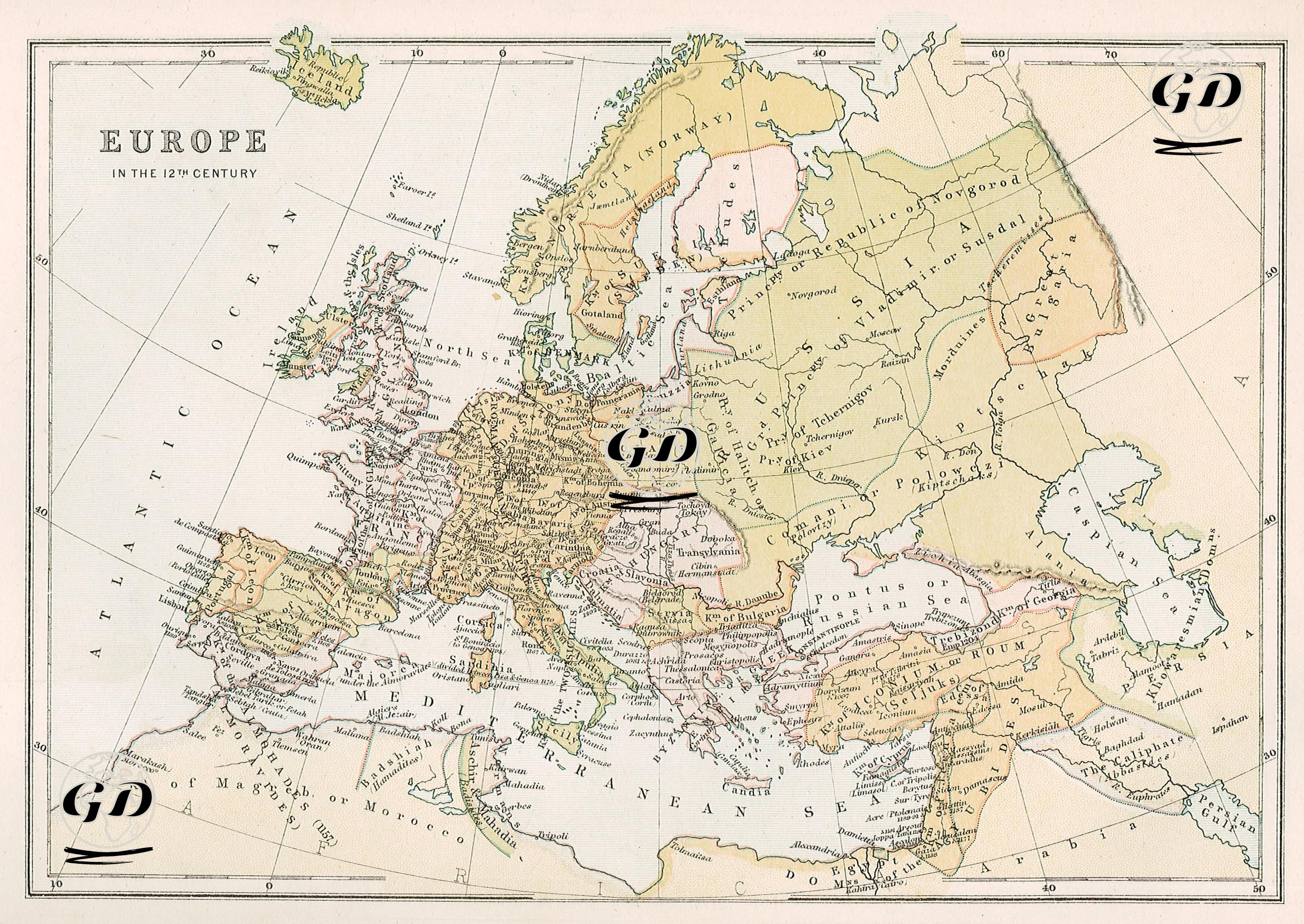
This map depicts the political and geographical structure of 12th-century Europe, and particularly medieval Europe as it was shaped after the Crusades, across a broad spectrum, from Byzantium to the Caliphate, from Normans to Catholic kingdoms. The map reflects not only political borders but also the vast religious, cultural, and diplomatic landscape of the period. At the center of the map, the Holy Roman Empire, encompassing most of Europe, stands out with its vast, dark expanse. This structure defines the empire's borders, encompassing all of Germany, present-day Austria, Switzerland, and northern Italy. However, rather than being a political unit, it was a fragmented structure ruled by feudal lords. Among the newly formed states in the east of the empire, the Kingdom of Poland, the Kingdom of Hungary, and various Slavic principalities stand out. On the Iberian Peninsula, the borders of Muslim and Christian powers are clearly visible on the map. As of 1157, the Almohad Empire, which ruled North Africa and the Iberian Peninsula, controlled the southern regions, while Christian kingdoms such as Castile, León, Navarre, and Aragon dominated the north and west. This corresponds to the middle stage of the Reconquista. Portugal was just beginning to take shape as an independent kingdom during this period. The conflicts between England and France can be seen on the map as territories united by Norman influence. Some parts of England were vassals of France, particularly Anjou, Normandy, and Aquitaine. This foreshadowed the long-term political and military tensions between the Plantagenet Dynasty and the Capetian Kingdom. Italy, meanwhile, was divided between the Imperial influence in the north and the Byzantine remnants and the Norman-founded Kingdom of Sicily in the south. The Norman influence, particularly in Sicily and southern Italy, is clearly illustrated on the map. During this period, the Kingdom of Sicily had a management model in which different cultures (Latin, Greek, Arab) were intertwined and it attracted attention with its multilingual and multi-religious structure. In the Balkans, the Byzantine Empire remains a powerful player, controlling Thrace, the Aegean Islands, Western Anatolia, Cyprus, and some coastal areas. However, the presence of various Slavic and semi-independent communities such as Serbs, Bulgarians, and Bosnians on the map indicates that Byzantine sovereignty in the region was constantly threatened. Moving east, the map reveals the influence of the Seljuk Turks and the Abbasid Caliphate. Mesopotamia and its surroundings are marked by the phrase "The Caliphate-Abbasides." Much of Anatolia is now under the control of the Seljuks and the Anatolian Principalities. This reflects the period after the Battle of Manzikert (1071), when the Turks began to establish themselves in Anatolia. While the name Turkey is not yet mentioned on the map, the established Turkish presence in Eastern and Central Anatolia is visually encoded. The map clearly illustrates the distinction between the Christian East and the West. The geographical and ideological boundaries between the European kingdoms of the Latin Church and the Orthodox Byzantine and Islamic worlds are marked by bold lines. During this period, under the influence of the Crusades, Latin kingdoms (e.g., the Kingdom of Jerusalem and the Principality of Antioch) were established in the Eastern Mediterranean; although the map does not specify these details, their contextual implications are perceptible. A striking feature of the map in Eastern Europe is the prominent depiction of the Novgorod Republic and the Russian Principalities (Suzdal, Kiev, Ryazan, and Tchernigov). This demonstrates the strengthening of the political autonomy of the Eastern Slavs and represents the period in which the seeds of the future Moscow-centered Russia were sown. This map is not only a geographical record; it is also a spatial projection of historical events such as the Crusades, the Norman expansion, the Reconquista, the decline of Byzantium, and the rise of the Turkish-Islamic world.