GRAVÜR DÜNYASI
Digital Engraving Library
| Date | 1878 |
| Technique | Lithography-Colored |
| Category | Maps |
| Source | The Collegiate Atlas - William Collins Sons & Co. Limited, Glasgow & London |
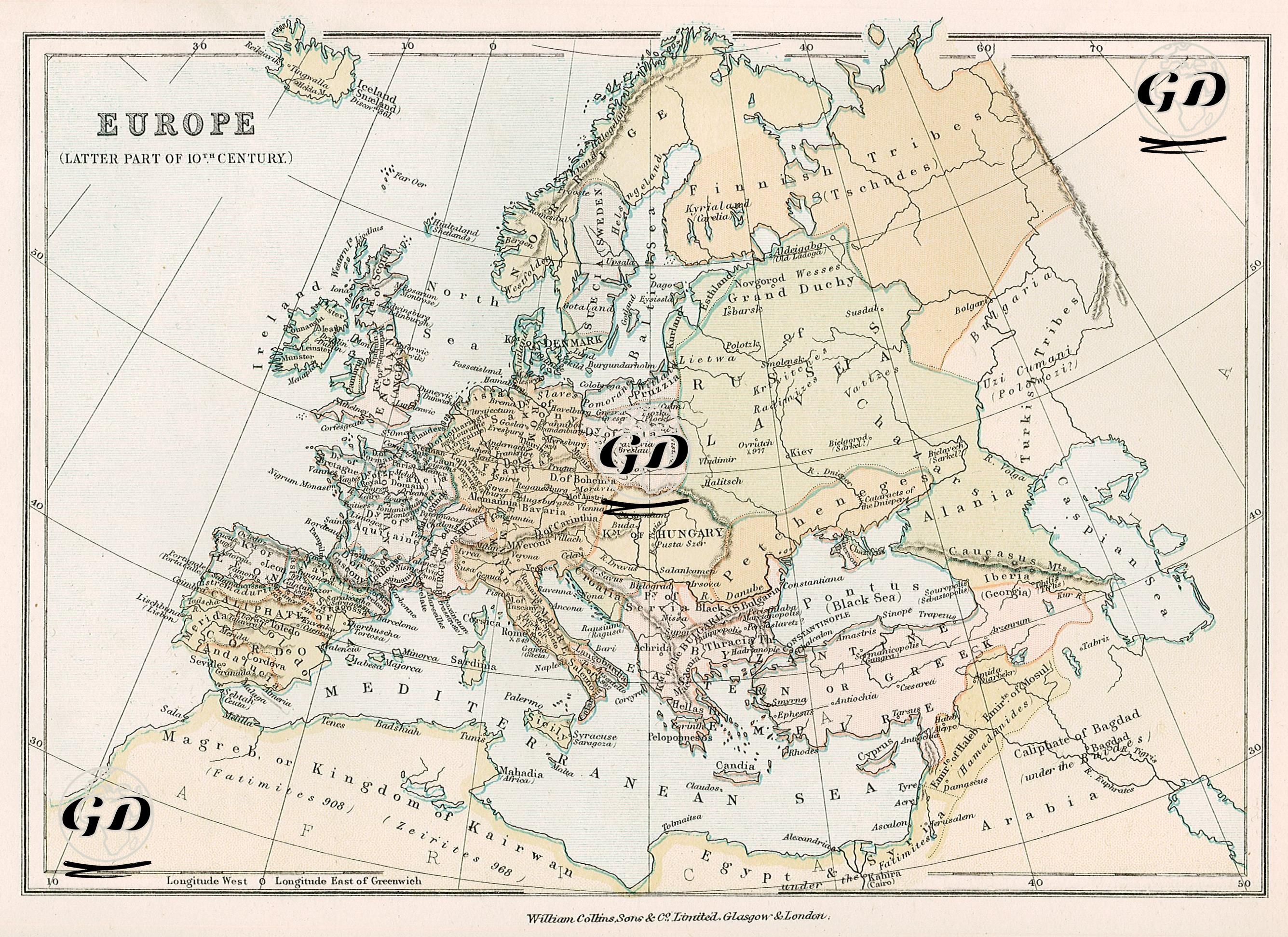
This map reflects the political and cultural landscape of Europe in the late 10th century, detailing the political structures, kingdoms, tribal communities, and major centers of power. During this period, the Carolingian Empire fragmented, giving way to numerous independent or semi-independent kingdoms. The most striking structure in Central Europe is the Holy Roman Empire. This empire, clearly marked on the map as encompassing present-day Germany, Switzerland, Austria, and northern Italy, is positioned as one of the most powerful political entities in Europe. Conversely, the Byzantine Empire and Muslim conquerors continue to influence the south. Sicily appears to be under Muslim rule. In Western Europe, France (Kingdom of the Franks) is clearly distinct, while England is undergoing a period of unification following the Anglo-Saxon kingdoms. Ireland and Scotland are represented as independent and fragmented kingdoms. The Hungarian Kingdom lies in the east, controlling a large area along the Danube River. The map shows nomadic steppe peoples such as the "Turkish Tribes" and "Petchenegs" east of this region, indicating a still-dense nomadic Turkic and proto-Turkic presence north of the Black Sea. It also reflects a periodic perception that these tribes posed a potential threat to Byzantium and the Eastern European kingdoms. The Balkans were still largely under the control of the Byzantine Empire. Constantinople (Istanbul) is centrally located on the map. Bulgaria and its surrounding area are populated by local Slavic kingdoms in constant conflict with Byzantium. Greece and the Aegean Islands are still shown as Byzantine territory. The Muslim region on the Iberian Peninsula, ruled by the Andalusian Umayyads, is marked as the "Caliphate of Cordova." This represents the westernmost representation of Muslim political presence in Europe. Christian kingdoms such as Leon, Navarre and Castile were shown in the north of the peninsula, representing the early stages of the Reconquista (Re-Conquest) process. Along the African coast, in the region known as the Maghreb, the term "Maghreb or Kingdom of the Fatimids" appears, indicating the Shiite Fatimid dominance in Egypt and North Africa. The "Caliphate of Baghdad" is located in the southeast of the map, symbolizing the Abbasid presence in the Middle East. The shaping of these areas by Islamic civilization is clearly emphasized. Overall, the map reveals the great civilizational differences, both geographically and politically, between the feudal kingdoms of Western Europe, the tribal structure of Eastern Europe, the resistance of Byzantium, and the rise of the Islamic world.