GRAVÜR DÜNYASI
Digital Engraving Library
| Date | 1878 |
| Technique | Lithography-Colored |
| Category | Maps |
| Source | The Collegiate Atlas - William Collins Sons & Co. Limited, Glasgow & London |
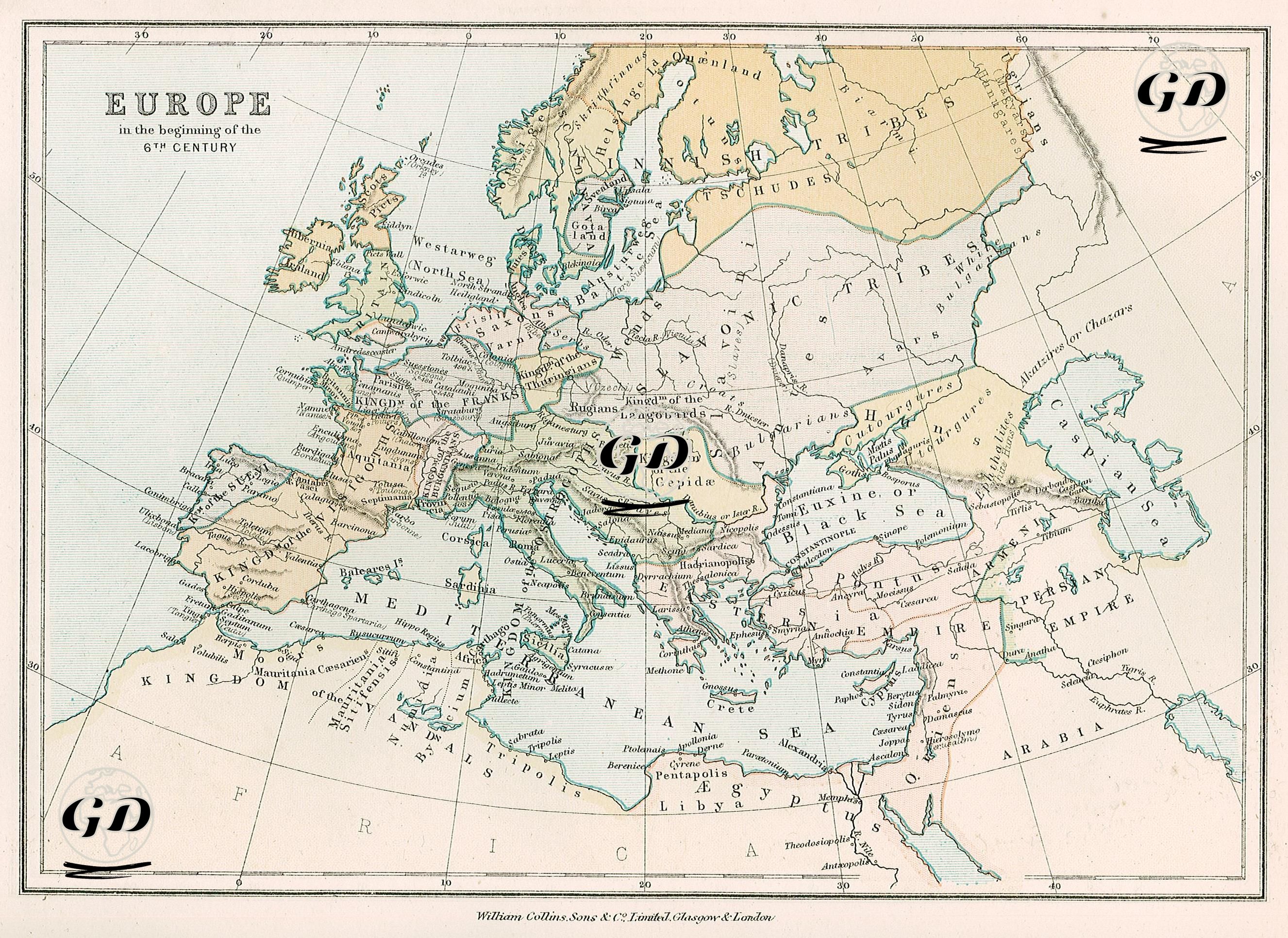
This map shows the political and ethnographic situation of Europe in the early 6th century. It visualizes the new balance of power that emerged in Europe after the collapse of the Western Roman Empire, the rise of barbarian kingdoms, the settlements of nomadic peoples, and the still-influential structure of the Eastern Roman (Byzantine) Empire. Following the fall of Western Rome in 476, Roman rule over the continent was replaced by various ethnic and political groups, including Germans, Alans, Huns, Gepids, Vandals, Visigoths, and Ostrogoths, each of which is detailed in this map with different color shadings. The Ostrogothic Kingdom ruled Italy, while the Frankish Kingdom largely controlled the territory of present-day France. Visigoths ruled much of the Iberian Peninsula, and the Vandal Kingdom occupied the North African coast. Gepids are prominently located in the Balkans, and proto-Slavic communities such as Bulgurs, Hunnic remnants, Avars, and Sclaveni are prominently located north of the Black Sea. The British Isles began to take shape under the influence of Germanic communities such as the Angles, Saxons, and Jutes, and the influence of Roman rule on the island had largely faded. The map also clearly demonstrates that the Byzantine Empire still held a strong presence in Anatolia, Greece, Thrace, Syria, Palestine, and Egypt; Constantinople, near the map's center, remained the political center of the Eastern Roman Empire. On the eastern border, the Sassanid Empire (Persian Empire) covered a vast area, emphasizing its border relationship with Byzantium. Large geographical areas in the northeast and east of the map were divided into ethnic groups with names such as "Scythian Tribes," "Huns," "Chazars," and "Slavonic Tribes," demonstrating the fragmentation of Europe along tribal lines that were not yet fully politically unified. The map visually demonstrates both regional differences and the political fragmentation caused by tribal migrations, as well as the historical and social structure of the period. This is reflected through accurate use of color and border drawings.