GRAVÜR DÜNYASI
Digital Engraving Library
| Date | 1878 |
| Technique | Lithography-Colored |
| Category | Maps |
| Source | The Collegiate Atlas - William Collins Sons & Co. Limited, Glasgow & London |
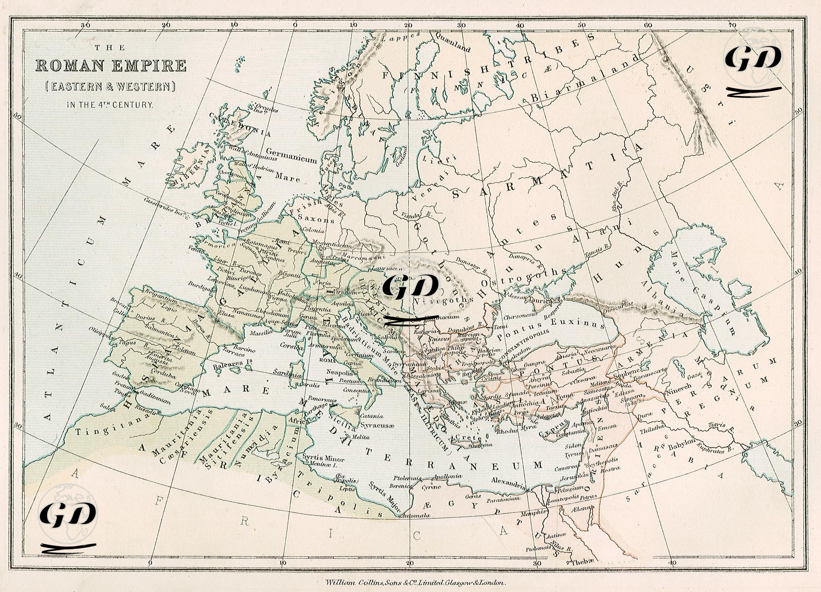
This map dated 1878 shows the geographical boundaries of the Roman Empire, which was divided into Eastern and Western in the 4th century. The map is rendered using the Latin forms of ancient place names and the geographical distribution of Roman-era tribes. The 4th century AD was a period of administrative rupture for the Roman Empire. The administrative division that began with the "Tetrarchy" system instituted during the reign of Diocletian (284–305) became permanent with the death of Theodosius I (379–395). In 395, the Empire was divided into two distinct political centers: Occidens (Western Rome), with its capital in Rome, and Oriens (Eastern Rome/Byzantine), with its capital in Constantinople. The map visually demonstrates this division very clearly. The Western Roman Empire is shown on the map as the green shaded area encompassing Gaul, Hispania, Britannia, North Africa and Italy, with important cities such as Rome, Londinium (London), Lutetia (Paris), Carthago, Mediolanum (Milan) and Massilia (Marseille) being notable. The Eastern Roman (Byzantine) territories encompassed the Balkans, Greece, Anatolia, Syria, Palestine, Egypt, and Mesopotamia; prominent cities in this region included Constantinople, Antiochia, Alexandria, Ephesus, and Jerusalem. Just beyond Rome's outer borders, the names of barbarian tribes such as the Ostrogoths, Visigoths, Alans, Sarmatians, Vandals, and Huns are inscribed, demonstrating the geographic origins of the dynamics associated with the 5th-century migration and the collapse of Western Rome. Other notable ancient features on the map include natural features that served as borders, such as the Pontus Euxinus (Black Sea), Mare Internum (Mediterranean Sea), Danubius (Danube), Rhenus (Rhine), Tigris, and Euphrates (Tigris and Euphrates). Several late-antique Roman provinces, such as Provincia Arabia, are also shown in detail. The map's visual design combined the aesthetics of classical ancient Roman cartography with modern 19th-century map-drawing techniques; colour gradation created a distinctive contrast between Roman territory and external areas, with tribes outside the borders placed against a light background.