GRAVÜR DÜNYASI
Digital Engraving Library
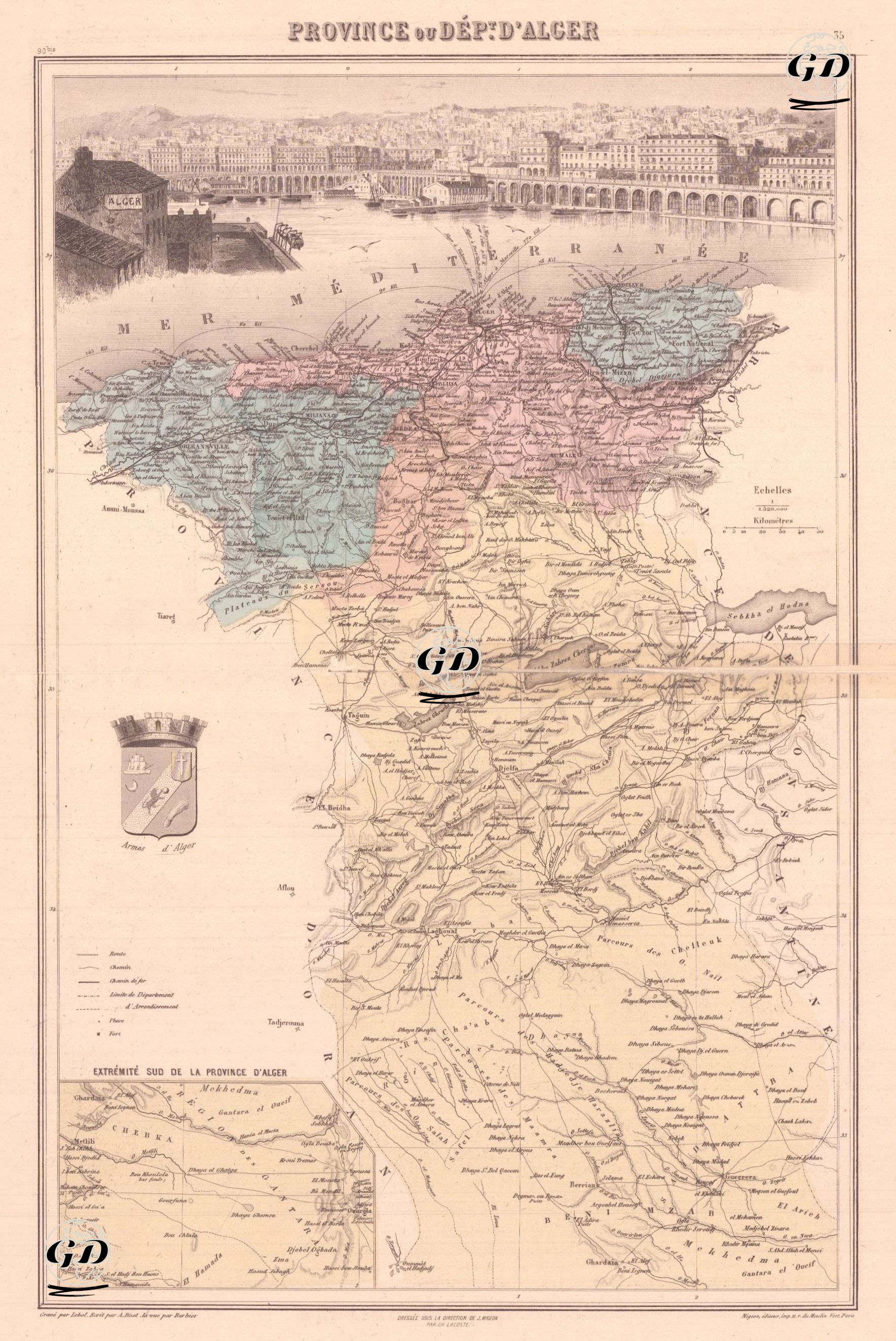
| Artist | A.Bizet-Barbier |
| Engraver | Lecocq |
| Date | 1889 |
| Technique | Steel Engraving-Original Hand Colored |
| Category | Maps |
| Source | Atlas France and its Colonies, published by J. Migeon - Dresse Sous La Direction De J.Migeon Par Ch.Lacoste - Migeon Editeur imp. 11 r. du Moulin Vert, Paris |
This detailed map, dating from the French colonial period, depicts the administratively defined Province of Alger (Algeria), reflecting both geographical and topographical distinctions and political divisions. Algeria became a military colony of France from 1834. According to the 1848 French Constitution, it became an integral part of French territory and was divided into three French departments (Algiers, Oran, and Constantine). The map's level of detail is quite high, containing a wealth of information, from tribal settlements to mountain passes, trade routes to military outposts. One of the map's most striking features is its detailed geographical information and panoramic visual element. The upper portion of the map features a highly detailed panorama of the port and city of Algiers, the capital city; this panorama serves as a descriptive visual of the city's geographic layout and architecture during that period. The lower portion of the map also includes an inset map detailing the sprawling interior and the southern desert borders. The entire map represents the administrative structure and geographical diversity of the province of Algiers under French rule, represented by three main color zones: Blue Zone (Northwest and West Coast); This zone encompasses the settlements directly established by France and integrated into maritime trade through ports. Important coastal cities such as Tenes, Cherchell, and Kolea are located within this color block. The coastal plains and maritime connections are decisive for both the military and economic importance of this region. Pink Zone (Central and Mountainous Transitional Zones); This zone extends along the Tell Atlas Mountains (the northern part of the Atlas Mountains system in North Africa, close to the Mediterranean coast) and includes important cities such as Blida, Medea, and Miliana. It is the mountainous transition zone where French garrisons are concentrated and tribal control is being broken. Both agricultural activities and local resistance are intertwined here. Geographically, it exhibits a complex topography divided by mountain ranges and valleys. Yellow Zone (Southern Desert Belt and Rural Areas): Occupying a large portion of the map, this region represents the vast semi-desert and nomadic tribal landscape bordering the Sahara. Settlements such as Bou Saada, Djelfa, and Laghouat, as well as areas inhabited by the Touareg and Sharifi tribes, are located within this vast region. It is a difficult area for the French administration to access and limited in its administration. The inset at the bottom left of the map, titled "Extrémité Sud de la Province d'Alger," contains a detailed representation of the southern borders of the province of Algiers. This inset provides information, in particular, on the routes of nomadic tribes, temporary water sources, and strategic outposts. The coat of arms on the left side of the map refers to the symbolic representation of Algiers during the French period. The legend at the bottom left of the map explains the symbols used on the map.