GRAVÜR DÜNYASI
Digital Engraving Library
| Artist | A.Bizet-Barbier |
| Engraver | Lecocq |
| Date | 1889 |
| Technique | Steel Engraving-Original Hand Colored |
| Category | Maps |
| Source | Atlas France and its Colonies, published by J. Migeon - Dresse Sous La Direction De J.Migeon Par Ch.Lacoste - Migeon Editeur imp. 11 r. du Moulin Vert, Paris |
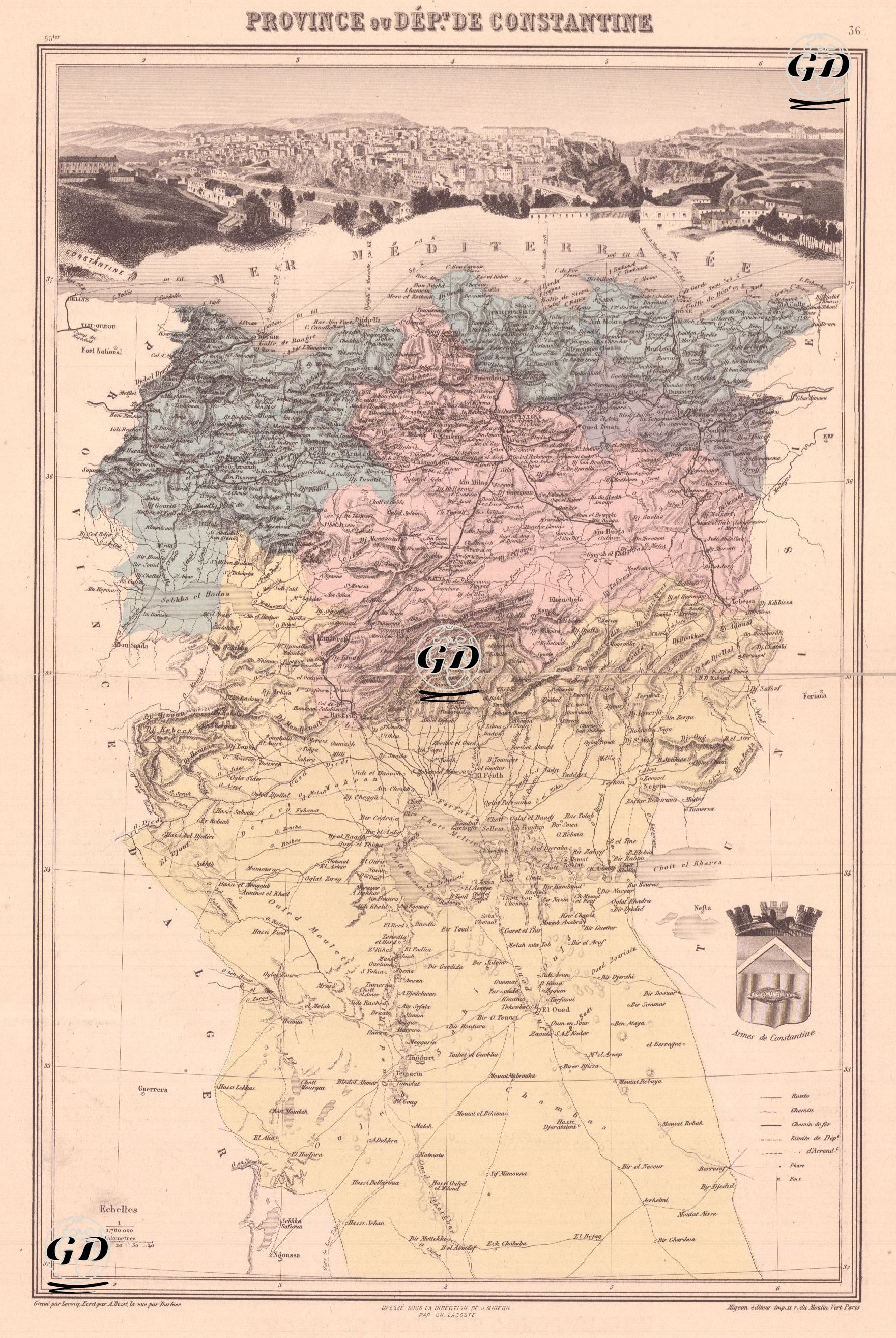
This map, dating from the French colonial period, shows in detail the administrative unit known as the "Province of Constantine or Department of Constantine," located in eastern Algeria. Algeria became a military colony of France from 1834. According to the 1848 French Constitution, it became an integral part of French territory and was divided into three French departments (Algiers, Oran, and Constantine). The map's level of detail is quite high, containing a wealth of information, from tribal settlements to mountain passes, trade routes to military outposts. One of the map's most striking features is its detailed geographical information and panoramic visual element. At the top of the map is a detailed panorama of the city of Constantine, serving as a visual representation of the city's geography and architecture during that period. The map is divided into three distinctly colored zones: Blue Zone (Northern Coastline); This area borders the Mediterranean and contains port cities of strategic importance to France. Port cities such as Philippeville (Skikda), Bone (Annaba), and Collo are located within this color block. Pink Zone (Inland-Atlas Transitional Zone): This color block forms a transition zone between the northern coastline and the semi-desert areas in the south. Constantine, the capital of the province, is located within this zone. Cities such as Setif, Mila, Guelma, and Batna are also included. Yellow Zone (Southern Semi-Desert and Rural Areas): This zone constitutes the largest part of the map and includes settlements such as Biskra, Ouled Djellal, El Kantara, and El Oued, as well as rural and semi-desert areas close to the Sahara. The prefecture's coat of arms is located in the lower right corner. This coat of arms, adorned with a three-towered crown, reflects the official symbolic approach of the French administration. The legend in the lower right corner of the map explains the symbols used on the map.