GRAVÜR DÜNYASI
Digital Engraving Library
| Artist | Claude Joseph Drioux (1820-1898)-Charles Leroy |
| Engraver | Lamblin-L.Smith |
| Date | 1872 |
| Technique | Steel Engraving-Original Hand Colored |
| Category | Maps |
| Source | Atlas Universel et Classique de Geographie - Librairie Classique Eugene Belin a Paris |
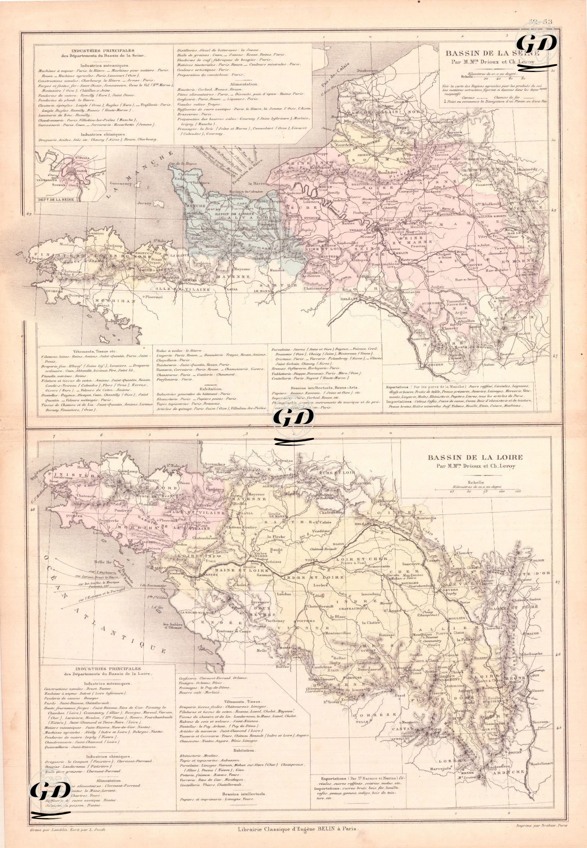
This map dated 1872 details the economic, industrial, and geographical structures surrounding the Seine and Loire rivers, two major river basins of 19th-century France. The "Bassin de la Seine" in the upper section of the map depicts the industrialized regions of northern France, particularly centered around Paris, while the "Bassin de la Loire" map in the lower section presents production networks and regional specializations in western and central France. Both sections are not limited to geographical data but also provide detailed city-by-city descriptions of major industries, production centers, raw materials, and trade routes through text blocks. The Seine Basin represents the industrial activity that developed around important cities such as Paris, Rouen, Le Havre, Amiens, Reims, Troyes, Orleans, Saint-Étienne, and Caen. Mechanical industries prominently include steam engines, agricultural machinery, foundry products, nails, and armor production, while chemical industries, particularly those focused on dyes, soap, pharmaceuticals, and salt production, are concentrated in areas such as paint, soap, pharmacy, and salt production. The food sector is notable for its flour mills, sugar refineries, biscuit, canned goods, chocolate, and pastry production. Local food processing activities such as wine production, salt mills, and cheesemaking also shape the economic identity of the Seine Basin. The clothing and textile industry focuses on high-quality clothing and wool and linen fabric production in and around Paris, while printing, publishing, and fine arts production are concentrated in centers such as Paris and Corbeil. In terms of trade, the Seine Basin exports sugar, grain, vegetables, meat, leather, fur, fashion goods, books, wine, and various industrial products through the ports of La Manche (the English Channel). Imports include cotton, coffee, cocoa, endigo, coal, iron, machinery, and chemical dyes. The Loire Basin, on the other hand, has a regional industry based mostly on raw materials, shaped around cities such as Nantes, Tours, Clermont-Ferrand, Le Mans, Angers and Limoges in the western and central regions of France. While armaments production, agricultural machinery, foundries, and steam engines played a dominant role in the mechanical industry, the chemical industry was concentrated around Clermont-Ferrand. The food industry strengthened the economic fabric of the Loire Basin with its salted butter, vinegar, jam, preserves, flour mills, and renowned cheese varieties. The textile industry, particularly in cities such as Châteauroux, Roanne, Laval, Cholet, and Angers, developed through cotton, wool, linen, shoes, and tailoring. The construction and housing sector was supported by furniture, tiles, ceramics, and china production in centers such as Limoges, Montluçon, and Aubusson. Production for intellectual needs was represented by printing, papermaking, and educational materials. Exports through the ports of Saint-Nazaire and Nantes included refined sugar, textiles, glass, fur, leather, spirits, and books, while imports focused on industrial raw materials such as cotton, coffee, cocoa, paint, iron, copper, and machinery. These detailed classifications on the map reveal not only economic geography but also the regional division of labor, industrial specialization, and transportation-trade relations of 19th-century France. Both rivers formed the backbone of these production models, providing both transportation and energy, and also enabled integration into global trade networks through ports. Therefore, this map should be considered not only a geographical document, but also a historical, economic, and industrial document.