GRAVÜR DÜNYASI
Digital Engraving Library
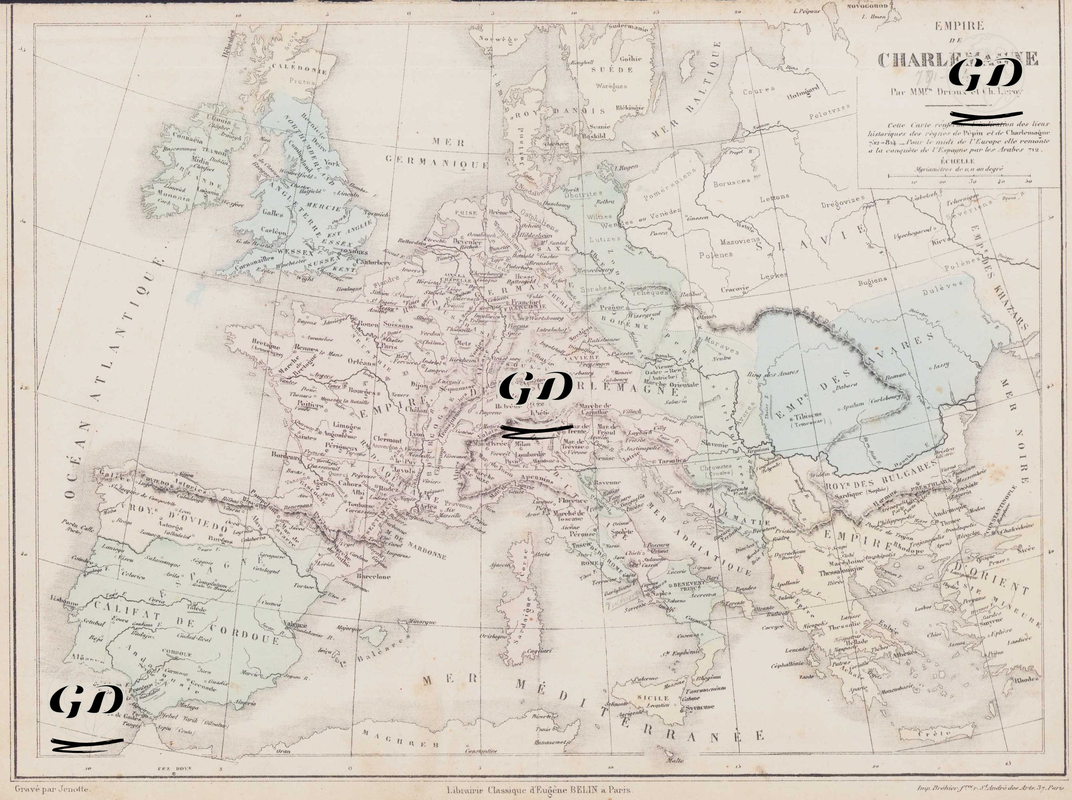
| Artist | Claude Joseph Drioux (1820-1898)-Charles Leroy |
| Engraver | Jenotte |
| Date | 1872 |
| Technique | Steel Engraving-Original Hand Colored |
| Category | Maps |
| Source | Atlas Universel et Classique de Geographie - Librairie Classique Eugene Belin a Paris |
This map shows the Frankish Empire at its greatest extent and its neighboring states during the reign of Charlemagne, who reigned from 768 to 814 AD. The map detailed the geographical scope and political environment of the vast empire Charlemagne established in Europe. The central area, labeled "CHARLEMAGNE" in the center of the map, encompassed a significant portion of Central Europe, including present-day France, Germany, Belgium, the Netherlands, Luxembourg, Switzerland, most of Austria, and Northern Italy. The map also included various regional designations reflecting the kingdom's administrative structure: the Frankish provinces of Neustrie, Austrasie, Bourgogne, Aquitaine, Septimanie, Provence, and Lombardy were clearly demarcated. To the east of the empire, the lands of the Slavic tribes (the Pays des Slaves) were shown extending to the Baltic Sea and positioned as hostile powers to the east. In the southeast of the map, the border lines with the Byzantine Empire (Empire d'Orient) and the "Royaume des Bulgares" (Bulgarian Kingdom) in the Balkans are evident. This suggests that political structures threatening Charlemagne's eastern borders were also considered. The area marked "Caliphate of Cordoue" (Cordoba Caliphate) on the western side of the map, on the Iberian Peninsula, defines Muslim-controlled Andalusia and highlights the border between the Franks and Muslims. Christian kingdoms of northern Spain, such as the Kingdom of Asturias, are also indicated on the map. In the British Isles, the map shows the Anglo-Saxon kingdoms of the Angles, Saxons, Scots, and Picts, and the regional Anglo-Saxon kingdoms of Mercie, Northumbria, Wessex, and Kent. On the Germanic side, areas populated by Germanic tribes such as the Thuringians, Saxons, Bavarois, and Allemands represent the communities conquered and converted to Christianity by Charlemagne. Important rivers such as the Rhine, Main, and Elbe define transportation and strategic lines within the empire. This map presents not only the lands under Charlemagne's rule, but also the neighboring states to which his political influence extended, the peoples who posed a threat, and the vast cultural-political geography of Europe at the time.