GRAVÜR DÜNYASI
Digital Engraving Library
| Artist | Claude Joseph Drioux (1820-1898)-Charles Leroy |
| Engraver | Jenotte |
| Date | 1872 |
| Technique | Steel Engraving-Original Hand Colored |
| Category | Maps |
| Source | Atlas Universel et Classique de Geographie - Librairie Classique Eugene Belin a Paris |
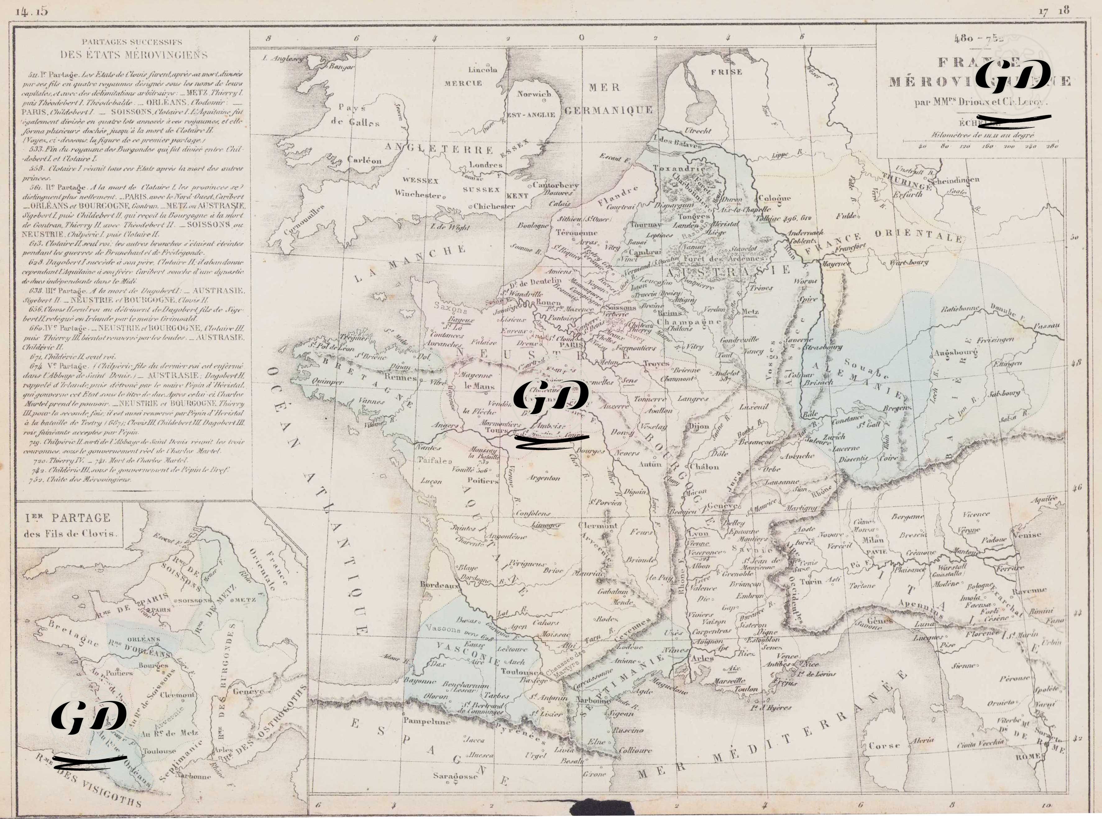
This 1872 map, titled "France Merovingienne," details the political geography of France during the reign of the Merovingian dynasty, which ruled from 480 to 752 AD, and reflects the various divisions and territorial arrangements within the dynasty. The text boxes in the upper left and the inset map in the lower corner also document the political fragmentation following the initial division among Clovis's sons. The map dates from the Merovingian period, the first royal dynasty founded by the Franks. Under the leadership of Clovis I, the Merovingians overthrew Roman authority in Gaul and established the Frankish Kingdom. The map illustrates the kingdom's gradual fragmentation around centers such as Soissons, Metz, Reims, Orleans, and Paris, and the emergence of regional centers of power. It is noteworthy that the Frankish lands, crossing the Rhine River in the east, extended into the interior of Germany and reached Provence and Septimania in the south. The map details important kingdoms and regions, particularly Austrasie (modern-day western Germany and eastern France), Neustrie (western Frankish territory), Bourgogne (Kingdom of Burgundy), Aquitaine (southwestern Gaul), Provence, and Septimania. The borderlands of non-Frankish Germanic tribes such as the Territoires des Alamans, Thuringians, Bavarois, and Lombards are also indicated. The legend in the upper left corner of the map details the territorial divisions among Clovis's sons during the Merovingian Dynasty. 1. Partage (511): After Clovis's death, the Frankish Kingdom was divided among his sons into four kingdoms: Soissons, Paris, Orleans, and Metz. Partage 2 (561): After the death of Chlothar I, the kingdom was divided again between Gontran (Burgundy), Sigebert (Austrasie), Chilpéric (Neustrie), and Charibert (Paris). The account summarizes the chronology of these divisions, the fragmented nature of Merovingian rule, and the struggles for the throne. The inset in the lower left corner of the map shows the initial division of power among Clovis's four sons after his death. Each established his own capital: Thierry I as Metz (Austrasie), Clodomir as Orleans, Childebert I as Paris, and Chlothar I as Soissons. The Merovingian Kingdom was shaped by the rise of the Franks after the end of Roman power in Gaul, laying the foundations for medieval France. However, the dynasty was weakened by divisions and struggles for the throne, ultimately giving way to the Carolingian Dynasty with the accession of Pepin II in 751.