GRAVÜR DÜNYASI
Digital Engraving Library
| Engraver | Josiah Neele (1804-1876) |
| Date | 1832 |
| Technique | Copper Engraving |
| Category | Maps |
| Source | Maps and Plans Illustrative of Thucydides - Engraved For & Published By J.Vincent, Oxford |
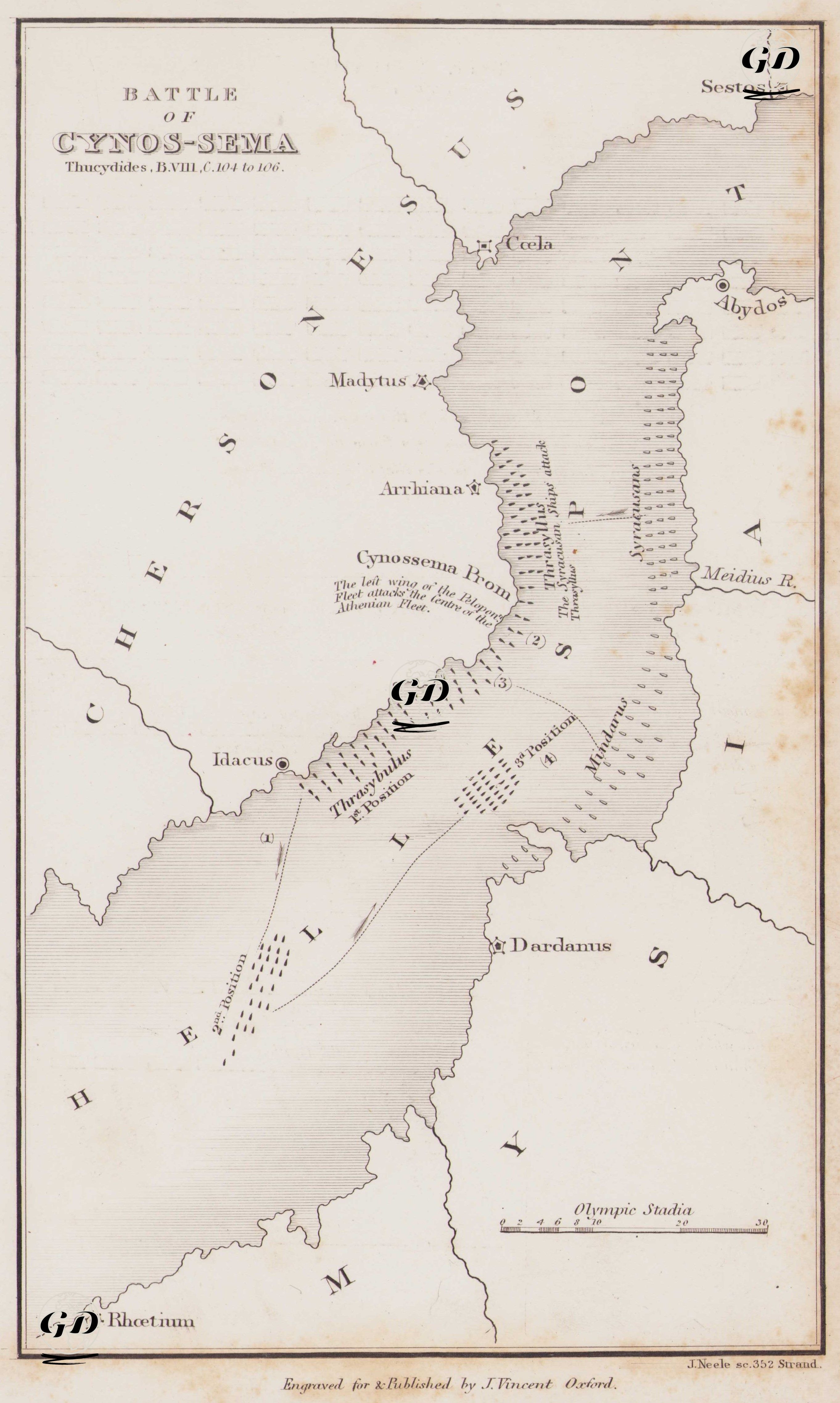
Thucydides (c. 460-400 BC) is considered one of the greatest historians of the ancient Greek world. His most important work, "The Peloponnesian War," covers the great war between Athens and Sparta that took place between 431 and 404 BC. An Athenian general himself, Thucydides personally participated in the war. Later, after being exiled, he traveled extensively, observing the war's development firsthand, and wrote a systematic, unbiased account based on eyewitness accounts. He is considered the first analytical historian to examine the cause-and-effect relationships of events. He emphasized the relevance of wars not only to heroism but also to strategy, politics, human nature, and the balance of power. In this respect, he is a pioneer of modern historiography. This map depicts the Battle of Cynossema (411 BC), which took place during the Peloponnesian War and was detailed by Thucydides in his book The Peloponnesian War. The battle took place between the Peloponnesian coalition led by Athens and Sparta, off the shores of Cynossema Cape, on the Dardanelles Strait (Hellespont), connecting the Aegean and Marmara Seas. Cape Cynossema is located on the inner side of the Gallipoli Peninsula, facing the Sea of Marmara, between Sestos (modern-day Eceabat) and Madytos (slightly south of modern-day Eceabat). The map depicts this naval battle in both topographic and tactical detail. The lower left corner of the map shows the Athenian fleet, under the command of Thrasybulus and Thrasyllus, sailing from Idacus (approximately near modern-day Kilitbahir) on the western shore of the strait. As the Athena fleet moves eastward across the sea, it encounters the Peloponnesian fleet commanded by the Spartan commander Mindarus. Positions 1, 2, and 3 shown on the map represent the turning points of this battle: 1. The first point of contact was the Peloponnesian fleet's attack north of Dardanus. 2. The Athenian right wing then retreated north along the strait, along the coastline, and launched a counterattack around Cape Cynossema. 3. The phrase "The left wing of the Peloponnesian fleet drove the center of the Athenian fleet" on the map indicates the critical moment of the engagement. However, the Athenians, with the inclusion of their center and left wings, switched from defense to attack, gaining maneuverability at sea and achieving an unexpected victory. The psychological impact of this battle was immense, as the Athenian navy gained morale for the first time since the earlier Sicilian disaster. As a result, this map presents Thucydides’ narrative in a concrete map form, detailing not only geographical locations but also naval battle tactics, fleet formations, and the stages of the war’s development. At the same time, the topography of the strait where the battle took place, coastal cities (such as Sestos, Abydos, Dardanos, Madytus) and the directions of naval maneuvers have been made visually understandable.