GRAVÜR DÜNYASI
Digital Engraving Library
| Engraver | Josiah Neele (1804-1876) |
| Date | 1832 |
| Technique | Copper Engraving |
| Category | Maps |
| Source | Maps and Plans Illustrative of Thucydides - Engraved For & Published By J.Vincent, Oxford |
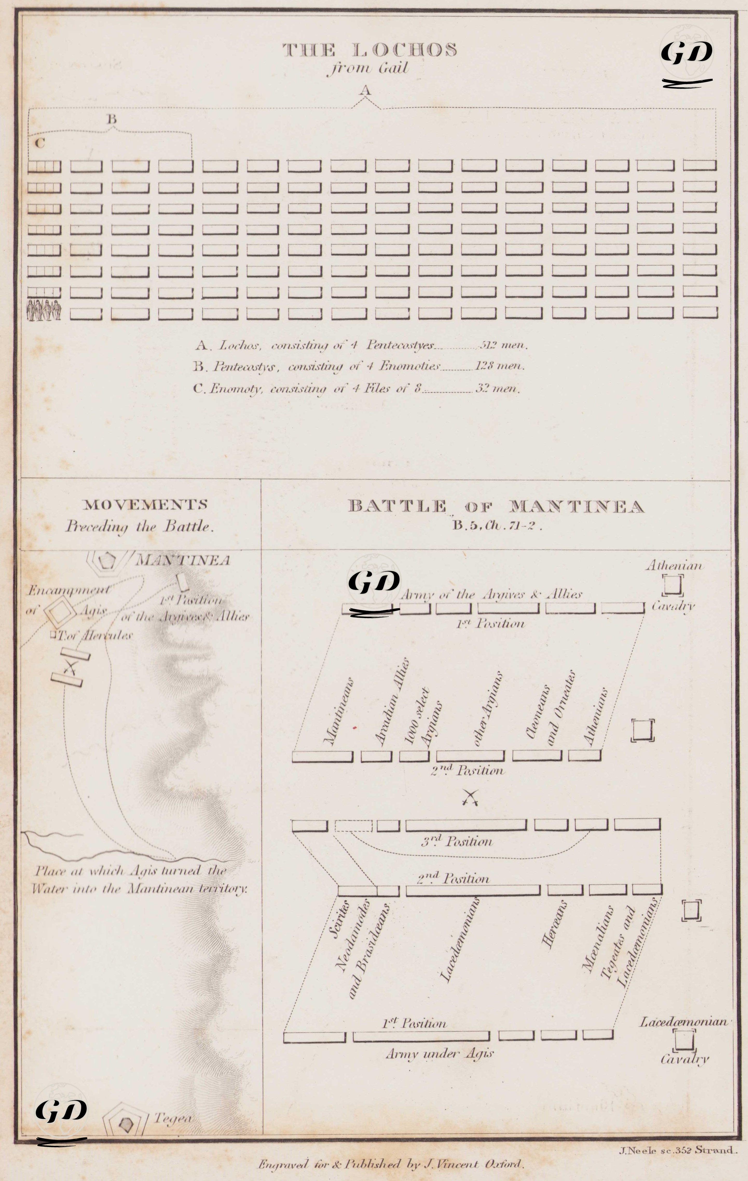
Thucydides (circa 460 BC-circa 400 BC) is regarded as one of the greatest historians of the ancient Greek world. His most important work, The Peloponnesian War, focuses on the great conflict between Athens and Sparta, which took place between 431 and 404 BC. Thucydides, himself an Athenian general, actively participated in the war. After being exiled, he traveled extensively to observe the progress of the war firsthand, and composed a systematic and impartial narrative based on eyewitness accounts. He is considered the first analytical historian to explore the causes and consequences of events. Rather than merely emphasizing heroism, he underscored the relevance of war to strategy, politics, human nature, and the balance of power. In this respect, he is a pioneer of modern historical writing. This engraved map illustrates one of the most important battles in ancient Greek military history—the Battle of Mantinea (418 BC)—depicting the formation of the armies and tactical maneuvers involved in the conflict. At the top of the map, under the heading “The Lochos from Call”, a classical lochos (Greek infantry unit) is shown schematically. According to the accompanying explanation, a lochos consists of 4 pentekostyes (totaling 512 soldiers); each pentekostys comprises 4 enomotiai (128 soldiers), and each enomotia is made up of 32 soldiers arranged in 8 ranks of 4 men. This layout is highly instructive in understanding how the hoplite phalanx was organized. At the bottom, the map visualizes the Battle of Mantinea in three phases, based on Thucydides’ account in The Peloponnesian War: 1. Movements Preceding the Battle: Spartan commander Agis attempted to divert the watercourse flowing through the valley (shown on the left of the map) to flood the territory of Mantinea. This was a strategic move designed to provoke the enemy and draw them into the open battlefield. 2. First & Second Positions: In the central part of the map, the initial formations of both armies are displayed. On one side stood the Aigospotamians, Mantineans, Arcadians, Argives, and Athenians; on the other were the Lacedaemonians (Spartans), Thebans, and their allies. These sequential positions illustrate how both sides kept maneuvering to gain a tactical edge. 3. Third Position: The final stage, where the actual clash occurred, shows both armies once again repositioned. The Spartans concentrated their experienced troops in the center to determine the outcome of the battle. The Athenian cavalry is shown stationed on the right flank. In this decisive phase, Spartan king Agis took bold initiatives, deviating from traditional discipline, and made sudden tactical decisions, redeploying units—moves that ultimately secured a Spartan victory. This triumph reaffirmed Sparta’s political and military dominance during the Peloponnesian War. In conclusion, this engraved map presents both the structure of ancient Greek military organization (Lochos formation) and the evolving tactical phases of a battle with vivid visual detail. It concretizes Thucydides’ narrative in both cartographic and schematic form, offering a unique window into classical warfare and the strategic logic of one of history’s most pivotal conflicts.