GRAVÜR DÜNYASI
Digital Engraving Library
| Engraver | Josiah Neele (1804-1876) - James Neele (active 1828-1832) |
| Date | 1832 |
| Technique | Copper Engraving |
| Category | Maps |
| Source | Maps and Plans Illustrative of Thucydides-Engraved For & Published By J.Vincent, Oxford |
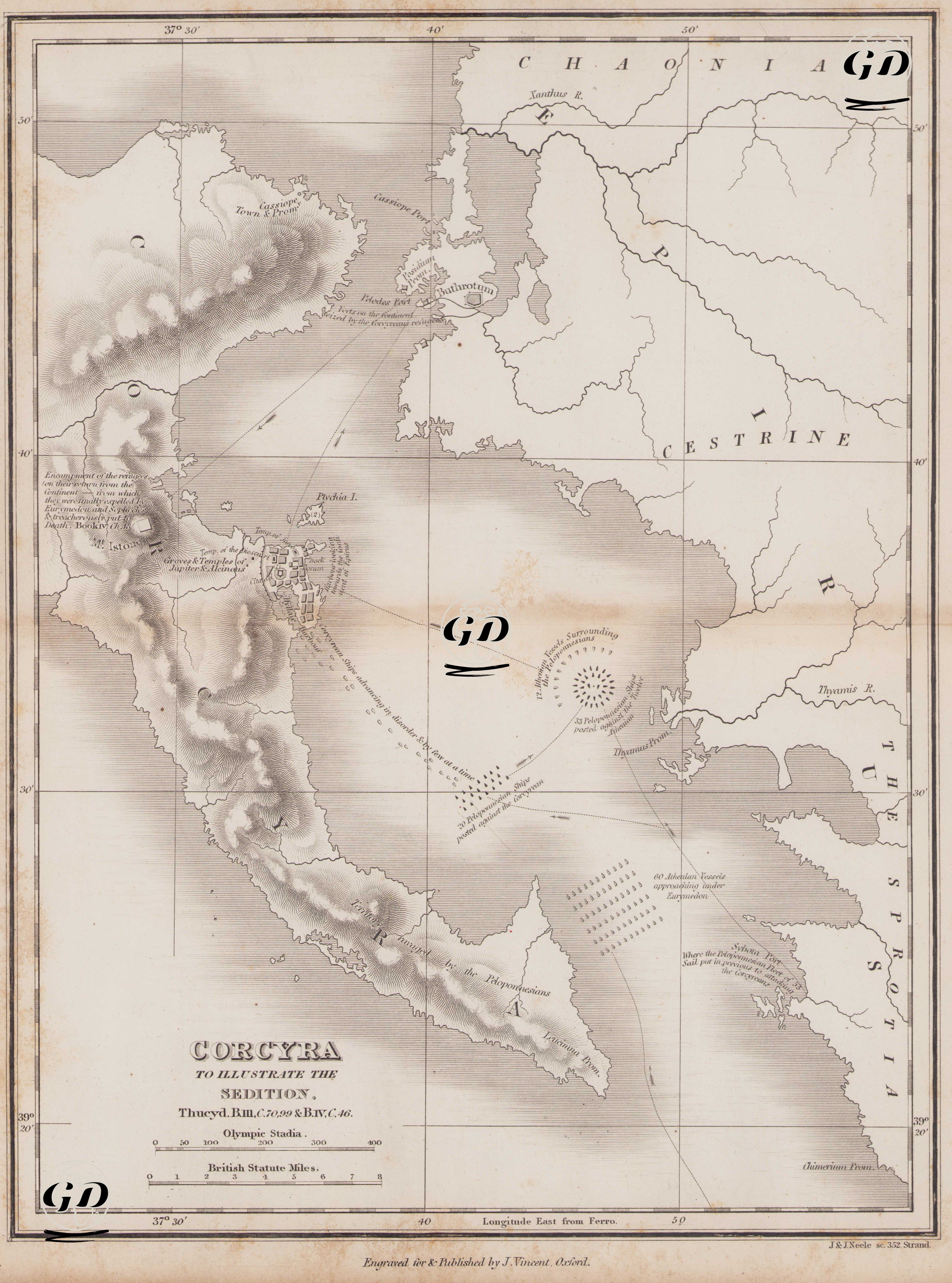
Thucydides (circa 460 BC-circa 400 BC) is regarded as one of the greatest historians of the ancient Greek world. His most important work, The Peloponnesian War, focuses on the great war between Athens and Sparta that took place between 431 and 404 BC. Thucydides, himself an Athenian general, actively served in the war. After being exiled, he traveled extensively to observe the progression of the conflict on-site and composed a systematic and impartial account based on firsthand testimonies. He is considered the first analytical historian to examine events through a cause-and-effect lens. He emphasized that war involves not only heroism but also strategy, politics, human nature, and the balance of power. In this respect, he is a pioneer of modern historiography. This engraved map was prepared to illustrate the civil war and naval battles in Corcyra (modern-day Corfu), events described in detail in Thucydides’ The Peloponnesian War. At the center of the map lies the island of Corfu (ancient Corcyra), part of modern Greece, while across the strait, the Epirus region is shown, including geographic elements such as Thesprotia, Chaonia, Cestrine, and the Thyamis River. The map reflects both the military and political dimensions of the tragic civil war that took place on Corfu in 427 BC. In this conflict, two major political factions within the city—the democrats (pro-Athenian commoners) and the oligarchs (pro-Spartan aristocrats)—engaged in a brutal struggle against each other. Thucydides referred to this conflict as seditio, a term that indicates not merely a physical battle, but also a collapse of values, loyalties, and the moral fabric of human nature. The map presents the positions of the Peloponnesian fleet, the locations of the Athenian navy, and the tactical maneuvers employed during the battle in detail. A circular depiction of the enemy fleet, surrounded by the Athenians, allows for a visual understanding of naval siege strategies. Similarly, the area of Istion, located near the northern part of the island, is marked as the site of the Athenian fleet’s encampment. On the eastern coast, Panormus and the Thyamis River are identified as positions held by Peloponnesian forces. Additionally, ports, fleet movement paths, naval attack directions, and coastal defenses are all illustrated. The civil war on Corfu stands out as one of the darkest and most striking events of the Peloponnesian War. The region shown on the map encompasses the areas directly affected by this conflict and clarifies its geographical context. The urban layout along the coast of Corfu, its internal harbors, and points of attack are all arranged in a manner consistent with Thucydides’ descriptions. In conclusion, this map concretizes Thucydides’ historical narrative in cartographic form, combining the dramatic and symbolic dimensions of civil war with strategic naval data. It also reveals how Greek city-states, as extensions of the larger Athenian-Spartan conflict, descended into internal collapse; how geography influenced the dynamics of conflict; and how it all reflects the political structure of the classical era.