GRAVÜR DÜNYASI
Digital Engraving Library
| Engraver | Josiah Neele (1804-1876) - James Neele (active 1828-1832) |
| Date | 1832 |
| Technique | Copper Engraving |
| Category | Maps |
| Source | Maps and Plans Illustrative of Thucydides-Engraved For & Published By J.Vincent, Near Brazen Nose College, Oxford |
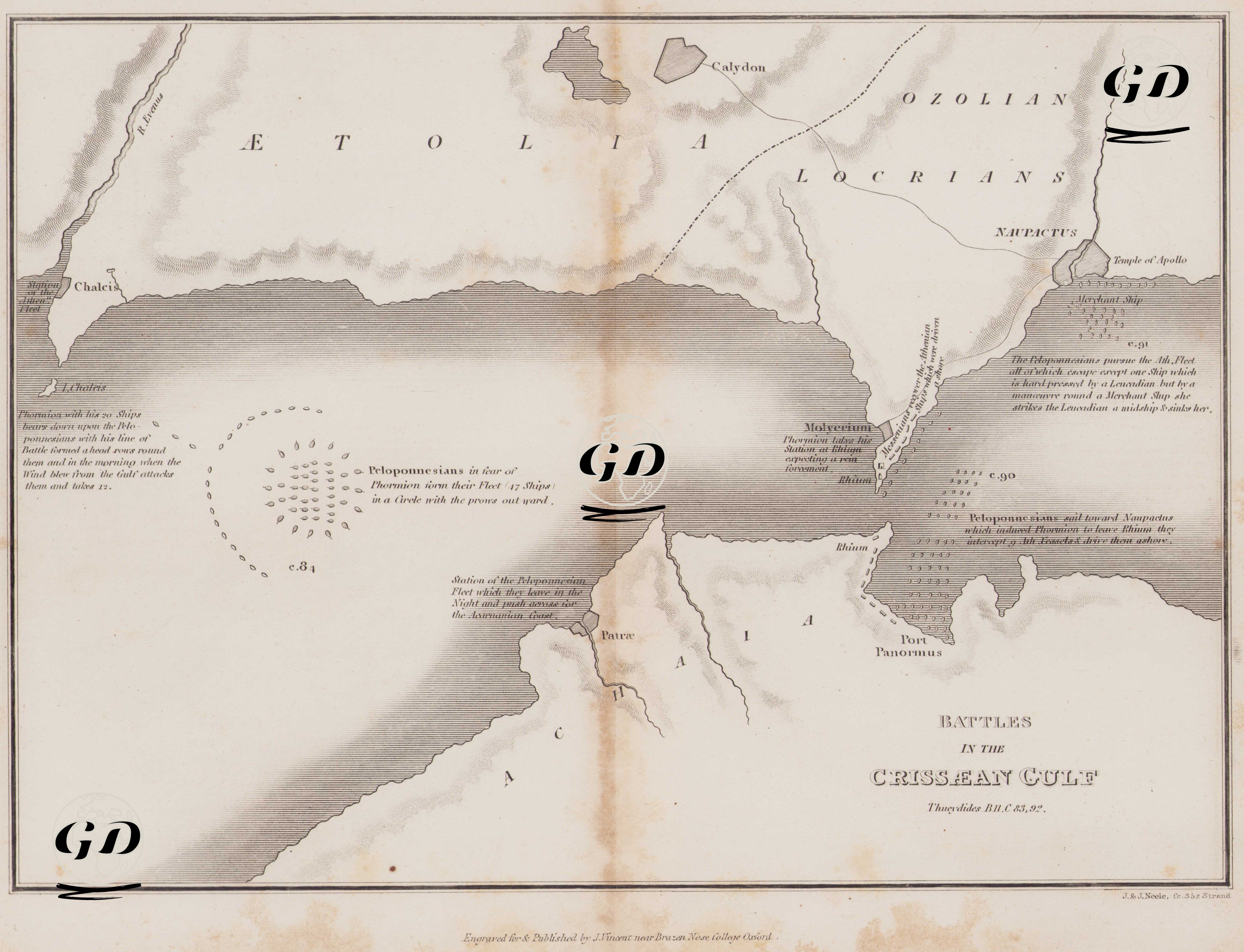
Thucydides (circa 460 BC – circa 400 BC) is regarded as one of the greatest historians of the ancient Greek world. His most important work, The Peloponnesian War, recounts the great war between Athens and Sparta that took place between 431 and 404 BC. Thucydides, himself an Athenian general, personally took part in the war. After being exiled, he traveled across a wide geography, observing the developments of the conflict on-site, and wrote a systematic and impartial narrative based on firsthand accounts. He is considered the first analytical historian to examine events through cause-and-effect relationships. He emphasized that wars are not only about heroism but also about strategy, politics, human nature, and balances of power. In this way, he is a pioneer of modern historiography. This map illustrates one of the most significant naval battles in ancient Greek history—the Naval Battles of the Crissaean Gulf—and is based on Thucydides’ The Peloponnesian War. The engraving presents, in topographical and naval detail, the region known today as the Gulf of Corinth and the tactical maneuvers that occurred there. The map clearly depicts the formation of the Peloponnesian fleet, the positions of the Athenian-aligned naval forces, the directions of attack, and the retreat maneuvers. In the lower-left portion of the map, the Peloponnesian fleet of 47 ships is shown arranged in a circular defensive formation. This classical formation aimed to create a more agile defensive perimeter against enemy attacks, with oarsmen positioned on the outer ring and command centers toward the middle. In accordance with Thucydides’ detailed descriptions, directional arrows are added to illustrate the maneuver by the Athenian commander Phormion, who launched a circular attack around the enemy fleet by exploiting the direction of the wind. When the wind suddenly shifted, the Athenian fleet turned inward and routed the Peloponnesian ships. In the upper-right section of the map, the final maneuver is shown in which Athenian ships fled to the port of Naupactus (modern Nafpaktos), established a defensive line there, and were nearly surrounded by the Peloponnesian fleet. However, one Athenian ship executed a masterful turn, sinking an enemy vessel, which restored the Athenians’ morale and dramatically changed the course of the battle. This engraving visually represents the strategic reasoning emphasized in Thucydides’ narrative, the influence of geography on warfare, and the technical aspects of naval combat. It also strikingly demonstrates that ancient warfare was not limited to land battles; maritime knowledge, wind, and currents played a vital role in tactical planning and outcomes.