GRAVÜR DÜNYASI
Digital Engraving Library
| Engraver | Josiah Neele (1804-1876) |
| Date | 1832 |
| Technique | Copper Engraving |
| Category | Maps |
| Source | Maps and Plans Illustrative of Thucydides - Engraved For & Published By J.Vincent, Oxford |
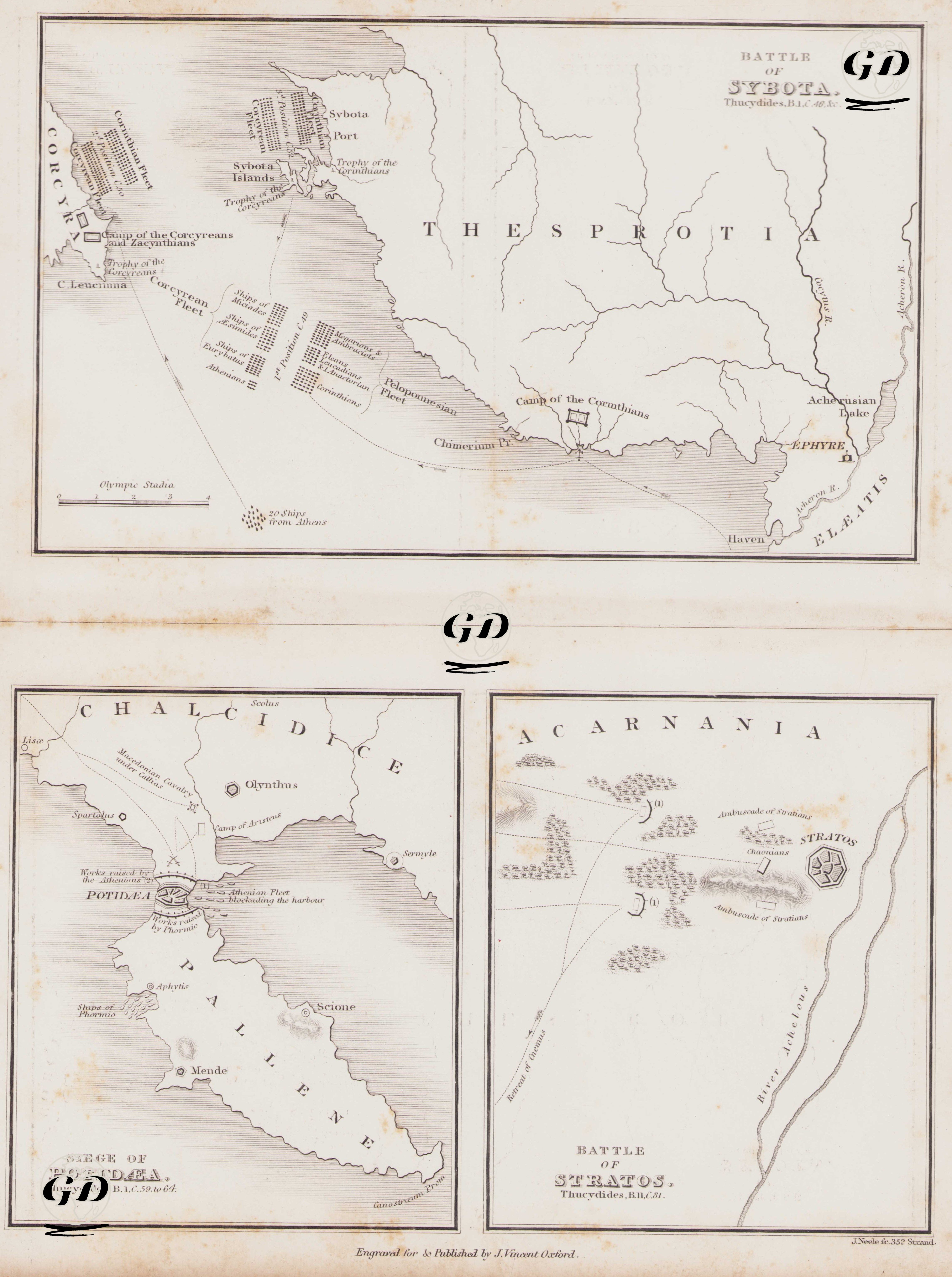
Thucydides (circa 460 BC-circa 400 BC) is regarded as one of the greatest historians of the ancient Greek world. His most important work, The Peloponnesian War, recounts the great conflict between Athens and Sparta that took place between 431 and 404 BC. Thucydides, himself an Athenian general, personally participated in the war. After being exiled, he traveled across a wide geography, investigating the course of the war on-site and writing a systematic and impartial account based on firsthand testimonies. He is considered the first analytical historian to examine events through a cause-and-effect lens. Rather than focusing solely on heroism, he emphasized the relevance of war to strategy, politics, human nature, and the balance of power. In this respect, he is a pioneer of modern historiography. This engraved map, based on Thucydides’ accounts, serves as a topographical reference to ancient Greek military history, visualizing three distinct battles: the Battle of Sybota, the Siege of Potidaea, and the Battle of Stratos. These maps illustrate the locations of ancient cities, troop deployments, naval maneuvers, and strategic encampments in detail. The large map at the top represents the Battle of Sybota, which took place in 433 BC. This naval engagement occurred between the fleets of Corcyra (Corfu) and Corinth near the Sybota Islands, located off the northwestern coast of present-day Greece. The engraving depicts the formation of the Corcyraean and Corinthian fleets, the arrival of a 20-ship Athenian reinforcement squadron, the Epirote coastline, the region of Thesprotia, and the Acheloos River. It shows both the pre-battle and battle-phase positions of the two sides and illustrates the resulting markers of victory—namely, the “Trophy of the Corinthians” and the “Trophy of the Corcyraeans.” Thucydides considered this battle a turning point on the road to the Peloponnesian War. The lower left map depicts the Siege of Potidaea, another critical front where tensions between Athens and Sparta escalated. The map details the geography of the Chalcidice Peninsula, including cities such as Olynthus, Spartolus, Acanthus, and Mende. It illustrates the Athenian encampment during the siege, the blockade of the harbor, and the naval strategy to seal off the port. In alignment with Thucydides’ narrative, it emphasizes Athens’ pressure on its colonies and the resistance from cities aligned with Sparta. The lower right map shows the Battle of Stratos in the region of Acarnania, which occurred in 429 BC. In this conflict, the Ambracian forces joined the Spartans in an attempt to attack Stratos but were repelled by the Acarnanians. The engraving carefully depicts the troop positions, the western bank of the river, ambush points, wooded areas, and the fortress of Stratos. The battle is presented in topographical form with close adherence to Thucydides’ detailed accounts of military formations and tactics. These three maps are invaluable not only for understanding military history but also for grasping the geographic foundations of ancient geopolitical conflicts. This engraving brings together academic depth and artistic detail, offering a compelling visual synthesis of ancient Greek war history as narrated by Thucydides.