GRAVÜR DÜNYASI
Digital Engraving Library
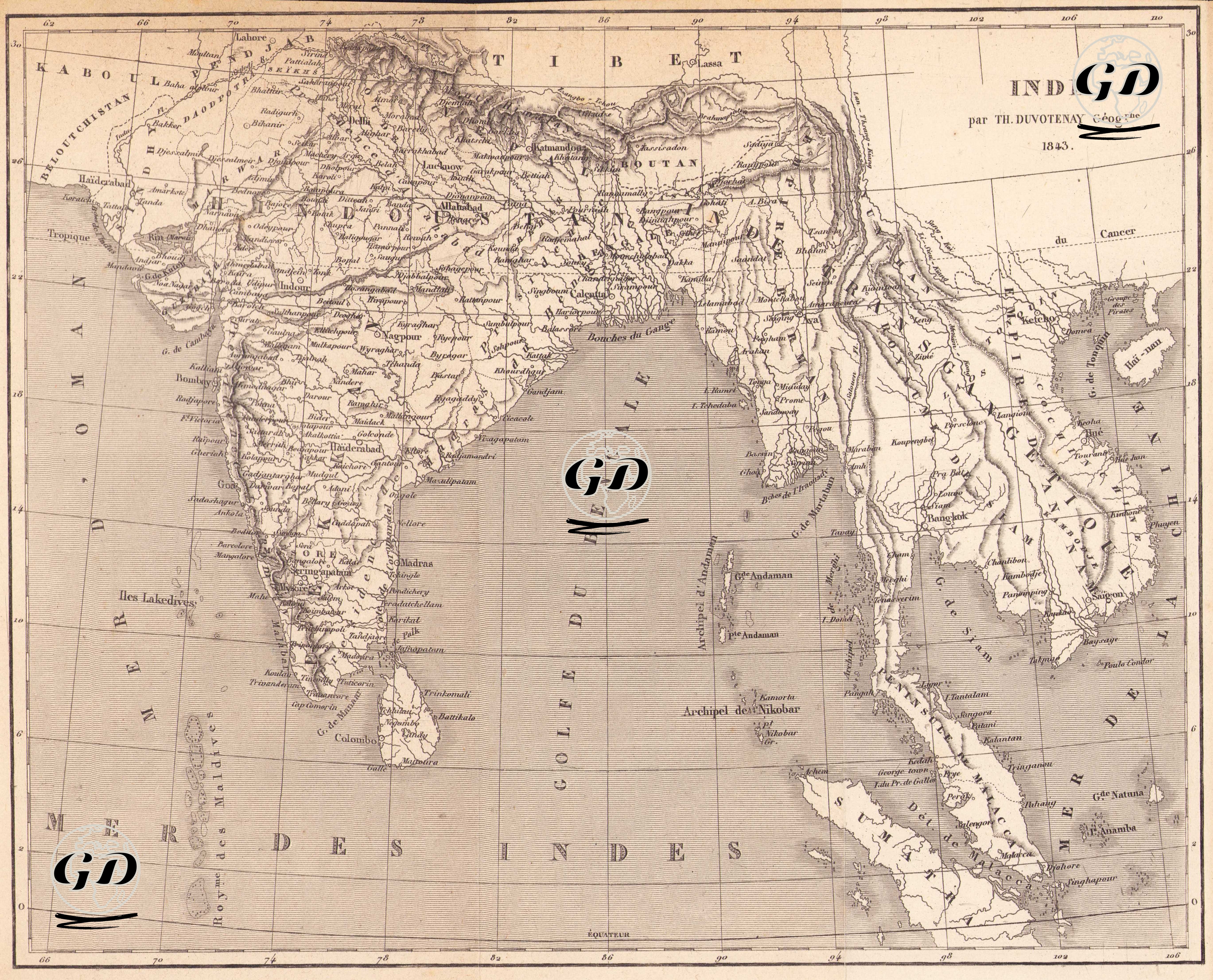
| Artist | Thunot Duvotenay (1796-1875) |
| Date | 1843 |
| Technique | Steel Engraving |
| Category | Maps |
This map, created by French geographer Thunot Duvotenay and published in 1843, is a detailed depiction of South Asia. Cartographically, it is drawn with both scientific precision and visual sophistication, documenting the geopolitical landscape of British India and the surrounding kingdoms, sultanates, and colonies in the mid-19th century. The map covers a broad region, including the Indian subcontinent, present-day Pakistan, Bangladesh, Nepal, Bhutan, Sri Lanka, Burma (Myanmar), and extending to the western coastline of the Southeast Asian peninsula. In the upper left corner, northwestern frontier areas such as "KABOUL" (Kabul) and "BELUTCHISTAN" (Baluchistan) are prominently shown, while the eastern edge clearly marks Southeast Asian territories like Siam (Thailand), Laos, and Cochin China (southern Vietnam). At the center of the Indian peninsula, the term "Hindoustan" is indicated, with regions such as "Inde Transgangetique" (Indian territories east of the Ganges River), the Bay of Bengal ("Golfe du Bengale"), the Indian Ocean ("Mer des Indes"), and the Malay Peninsula also depicted in detail. City names on the map reflect the transliteration conventions of that era; for example: "Calcutta" (Kolkata), "Bombay" (Mumbai), "Madras" (Chennai), "Hyderabad," "Lahore," "Delhi," "Benares" (Varanasi), and "Colombo" (in Sri Lanka) are among the major urban centers prominently displayed. Additionally, islands such as the "Isles Lakedives" (Laccadive Islands), "Archipel des Andaman" (Andaman Islands), and "Archipel des Nicobar" (Nicobar Islands) are clearly illustrated. Political boundaries are indicated by linear demarcations rather than colors, reflecting the colonial power dynamics of the period. The year 1843 was a period during which British control over India was intensifying, and the map vividly portrays the geographic extent of that influence. Moreover, critical geographical features such as the Tibetan Plateau, the Himalayas, the Ganges River basin, and the Deccan Plateau are accurately placed and detailed.