GRAVÜR DÜNYASI
Digital Engraving Library
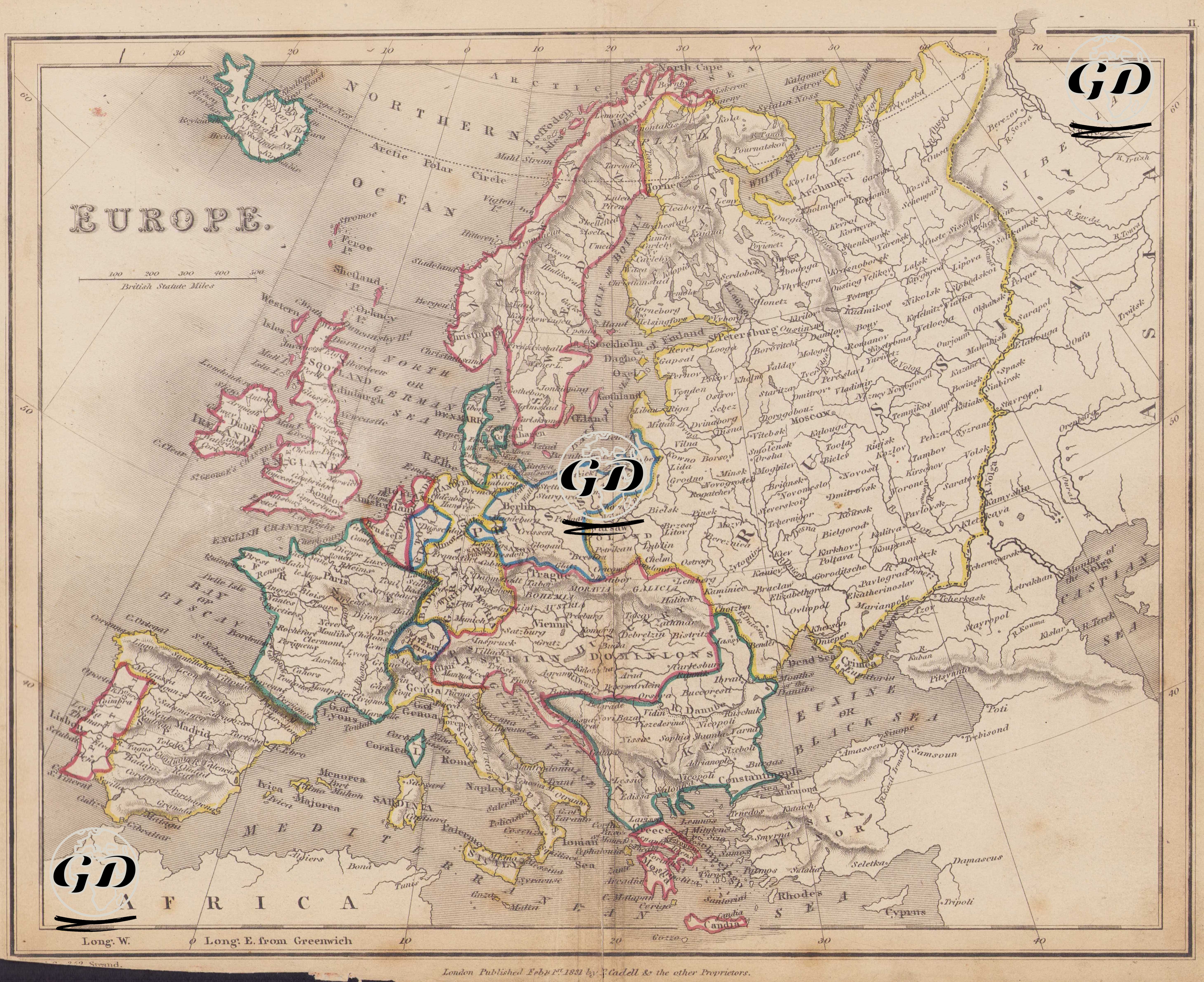
| Engraver | Josiah Neele (1804-1876) - James Neele (active 1828-1832) |
| Date | 1831 |
| Technique | Copper Engraving-Original Hand Colored |
| Category | Maps |
| Source | London Published Feb 1 1831 by T.Cadell & the other Proprietors |
This map of Europe dated 1831 reflects the political geography of a period when the post-Napoleonic balance was established, the borders established by the 1815 Congress of Vienna dominated Europe, dynasties were being re-established, and nationalist movements were still in their early stages. At this time, Europe was still ruled by major dynasties and empires, and the rise of nation-states had not yet begun. By highlighting the borders and geographical expansion of these great powers with colored contours and major urban centers, the map reflects the political map of the period in both diplomatic and geographic dimensions. Prominent Political Structures on the Map: 1. Austrian Empire: The Habsburg territories included regions such as Austria, Bohemia, Hungary, Transylvania, Lombardy-Venetia, and Galicia. As the central power of Central Europe, Austria bordered numerous countries on its eastern, western, and southern borders. Vienna (Vienna) is also highlighted on this map as a political and cultural center. 2. France: France, which entered the Louis-Philippe era after the July Revolution of 1830, is shown on the map with its 1815 borders. The Rhine River is clearly drawn on France's eastern border, and cities such as Paris, Lyon, and Bordeaux are shown. 3. United Kingdom: England, Scotland, Ireland, and Wales are shown together on the map, and the British Isles are marked collectively. Central cities such as London, Edinburgh, and Dublin are selected. Although the British Empire was outside direct borders on the European continent during this period, it held a central place on the map with its maritime and colonial power. 4. Spain and Portugal: The political borders of the reigns of Ferdinand I and Fernando VII are clearly visible on the map. The coastal and inland areas of both countries are detailed, but their internal administrative divisions are not depicted. 5. Russian Empire: "Russia," bordered in yellow on the east of the map, encompasses a vast geography stretching from the Baltic coast to the Black Sea, and from Poland to the Urals. Centers such as Moscow, St. Petersburg, Odessa, Kiev, and Kazan are shown. Although the word "Poland" appears on the map, Poland was not an independent state during this period. It was abolished in the third partition in 1795 and appears on the map as being shared between Russia, Prussia, and Austria. 6. Ottoman Empire: Marked in the southeast of the map is the phrase "TURKEY IN EUROPE." The Rumelian provinces (Bosnia, Bulgaria, Macedonia, Greece, and Thrace), encompassing the present-day Balkans, are included in this region. Constantinople (Istanbul) is shown as the strategic center connecting both Europe and Asia. 7. Italian Peninsula: Italy, not yet unified, is shown on the map as separate administrative areas such as the States of Church (Papal States), Naples (Kingdom of Naples - Two Sicilies), and the Kingdom of Sardinia. 8. Scandinavia: Sweden and Norway are shown as a single kingdom after the union in 1814. Finland has been a part of Russia since 1809 and is also located within Russian borders on the map. Denmark is shown with the Jutland Peninsula and surrounding islands; Iceland is also depicted in the upper left corner. 9. Prussia and Germany: The large area marked "Prussia" and "Germany" on the map is the forerunner of the German states that would unite in the mid-19th century. 10. Greece: It declared independence in 1830 and is identified as "Greece" on the map. The map is prepared in British Statute Miles, and longitude lines are shown according to the "Longitude E. & W. from Greenwich" system. Borders are marked with different colors; mountains are shown using the shading method (hachure), and rivers are shown with detailed flow charts. The external borders of the countries are clearly defined, while internal administrative structures are kept simple.