GRAVÜR DÜNYASI
Digital Engraving Library
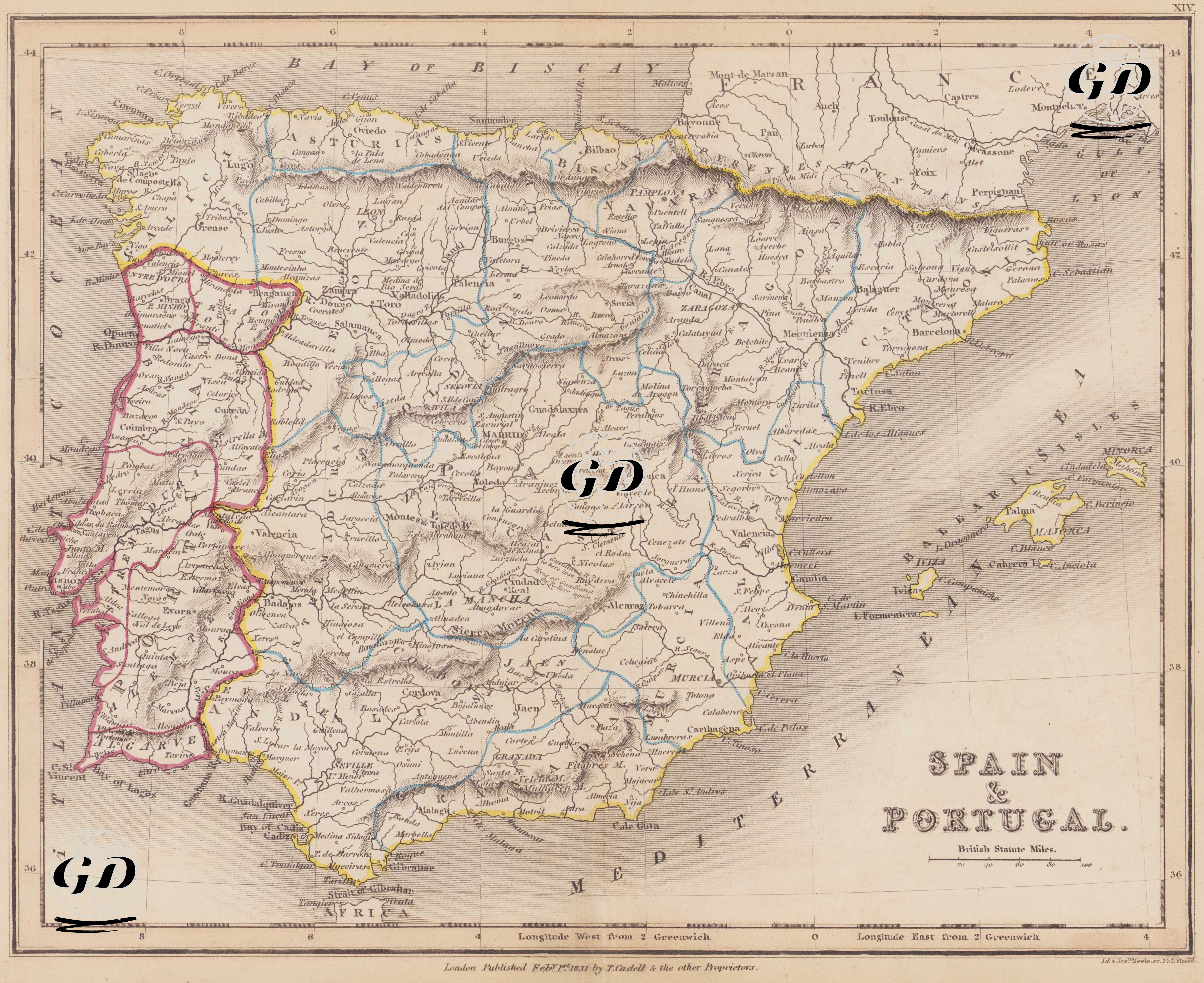
| Engraver | Josiah Neele (1804-1876) - James Neele (active 1828-1832) |
| Date | 1831 |
| Technique | Copper Engraving-Original Hand Colored |
| Category | Maps |
| Source | London Published Feb 1 1831 by T.Cadell & the other Proprietors |
This map dated 1831 depicts the political and geographic structure of the Iberian Peninsula in detail. It shows the internal divisions, principal cities, and mountain and river systems of both the Kingdoms of Spain and Portugal in detail, while also revealing their geographical connections to each other and the rest of Europe. The map depicts each country bordered in different colors, with its interior regions marked by border lines. Portugal is outlined in reddish purple, Spain in yellow, and its administrative divisions in the interior are marked in blue. To the east of the map, the land borders with France are clearly shown, particularly through Catalonia (Barcelona), Aragon (Zaragoza), Navarre (Pamplona), and the Basque Country (Bilbao, San Sebastian). To the northwest, the Bay of Biscay, and to the east, the Mediterranean coast and the Balearic Islands (Majorca, Minorca, and Ivica) are depicted in detail. To the south, just across the Strait of Gibraltar, is the silhouette of the North African coast with the word "Africa" written on it. The administrative divisions within Spain during this period are shown based on the "provincia" system, which was reorganized after the Napoleonic era. The region of Castile, centered in Madrid, is positioned at the heart of the Iberian Peninsula. Major cities such as Barcelona, Valencia, Seville, Cordoba, Granada, Malaga, Toledo, Salamanca, Burgos, León, and Zaragoza are marked as both administrative centers and strategic transportation hubs. Major rivers such as the Ebro, Tajo, Guadiana, and Guadalquivir are drawn, occasionally following settlements, and are highlighted as important routes for agricultural production and inland transportation. The Kingdom of Portugal is located in the west of the map. The capital, Lisbon (Lisboa), is indicated as a central coastal city. Among Portugal's major cities, centers such as Oporto, Coimbra, Évora, Braga, Setúbal, and Faro are clearly shown. Portuguese territories are marked according to their internal administrative divisions, reflecting not only the country's independent political structure but also its internal administrative organization. Cartographically, the map was drawn with the British Statute Mile scale and longitudes were given east and west from Greenwich. The map shows topographic elevations using the shading method (hachure), in accordance with classical 19th-century cartography, so that important elevations such as the Pyrenees Mountains, Sierra Nevada, Sierra de Guadarrama, and Montes de Toledo can be distinguished.