GRAVÜR DÜNYASI
Digital Engraving Library
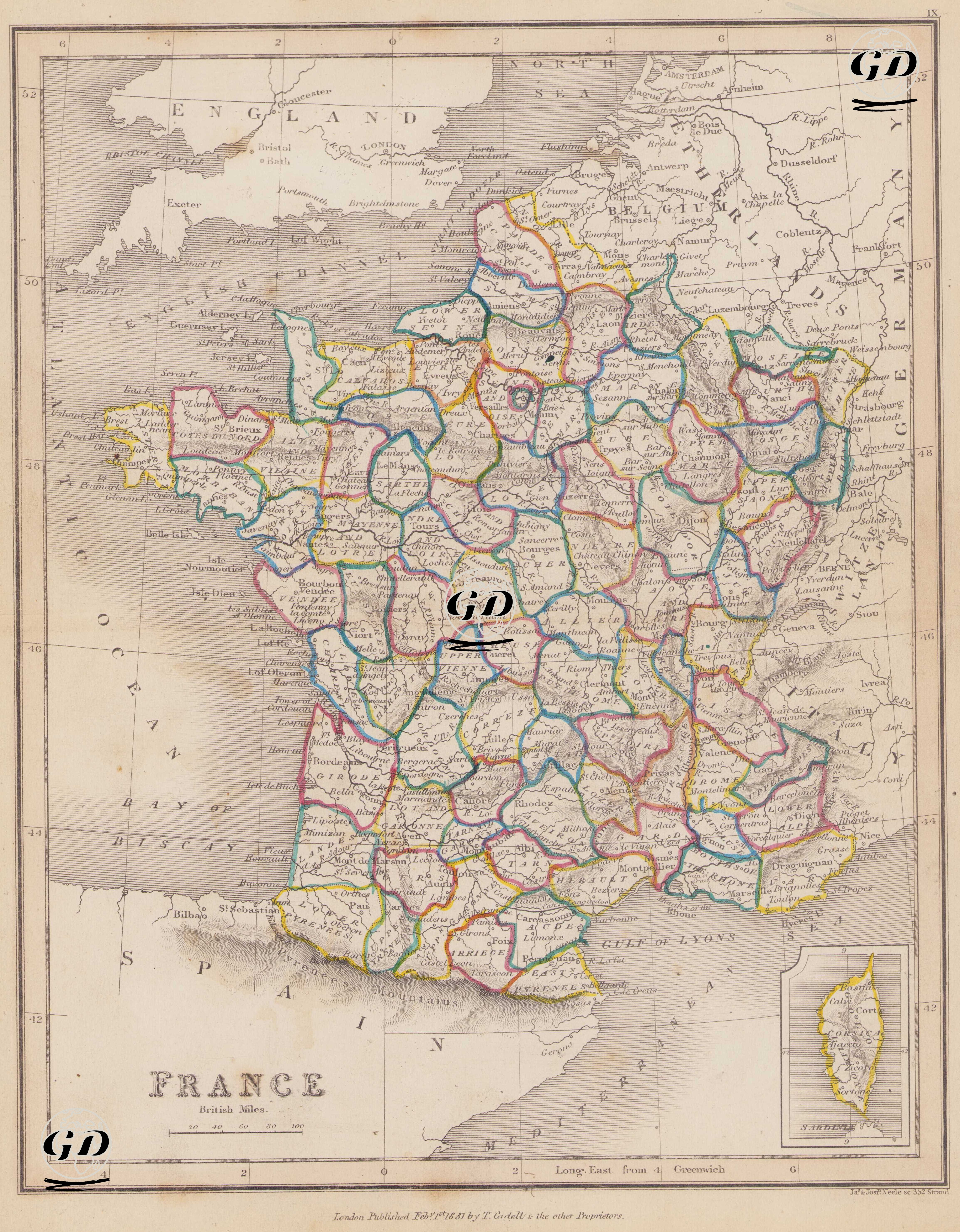
| Engraver | Josiah Neele (1804-1876) - James Neele (active 1828-1832) |
| Date | 1831 |
| Technique | Copper Engraving-Original Hand Colored |
| Category | Maps |
| Source | London Published Feb 1 1831 by T.Cadell & the other Proprietors |
This map dated 1831 shows in detail France's administrative structure, geographical boundaries, and territorial integrity in the early 19th century. The map not only depicts the internal borders of Europe as it was reorganized after the Napoleonic Wars, but also reflects the modern "département" system established after the French Revolution in detail across the entire country. The map presents France as divided into départements, each defined by a central city, separated by colored borders. This system was the product of the reforms following the 1789 Revolution that abolished feudal provincial structures and divided the country into equal-sized administrative units. Paris is marked in a circular shape, highlighting it as the national capital and positioning it at the very center of the Île-de-France region. The map also clearly displays major cities of the period, such as Lyon, Marseille, Bordeaux, Toulouse, Nantes, Lille, Rouen, Strasbourg, Dijon, and Orléans. The western and northwestern parts of the map encompass the provinces along the Atlantic Ocean and the English Channel, while the Brittany region is shown divided into departments that retain their traditional cultural identity. Normandy is similarly represented by departments such as Calvados, Manche, and Seine-Inférieure. In the south, the Pyrénées region, where Basque influence is felt, and the departments within the Occitan cultural region are detailed. The map reveals that historical regions such as Provence, Dauphiné, Languedoc, Gascogne, and Auvergne are no longer formal administrative structures but rather culturally definable areas, replaced by the modern departmental system. In the east of the map, the borderlands with Germany and Switzerland are more densely illustrated, particularly in strategically important areas such as Alsace and Lorraine. These regions would later become the scene of conflict with Germany after the Franco-Prussian War (1870–71), but are still represented as part of France during this period. The Nord department, located on the Belgian border in the north, was on its way to becoming one of the major centers of France's industrial revolution. In the lower right corner of the map, the French island of Corsica (Île de Corse) is also shown as an inset. Corsica was fully integrated into France during this period and, as the birthplace of Napoleon Bonaparte, holds both strategic and symbolic value. Cartographically, the map is measured using the British Statute Mile scale, with longitudes shown using the Longitude East from Greenwich system. Rivers, mountain ranges, gulfs, and coastlines are detailed using the hachure (shading) technique characteristic of the period. Important rivers include the Seine, Loire, Rhone, Garonne, and Meuse, highlighted on the map for their use in transportation, agriculture, and trade.