GRAVÜR DÜNYASI
Digital Engraving Library
| Engraver | Josiah Neele (1804-1876) - James Neele (active 1828-1832) |
| Date | 1831 |
| Technique | Copper Engraving-Original Hand Colored |
| Category | Maps |
| Source | London Published Feb 1 1831 by T.Cadell & the other Proprietors |
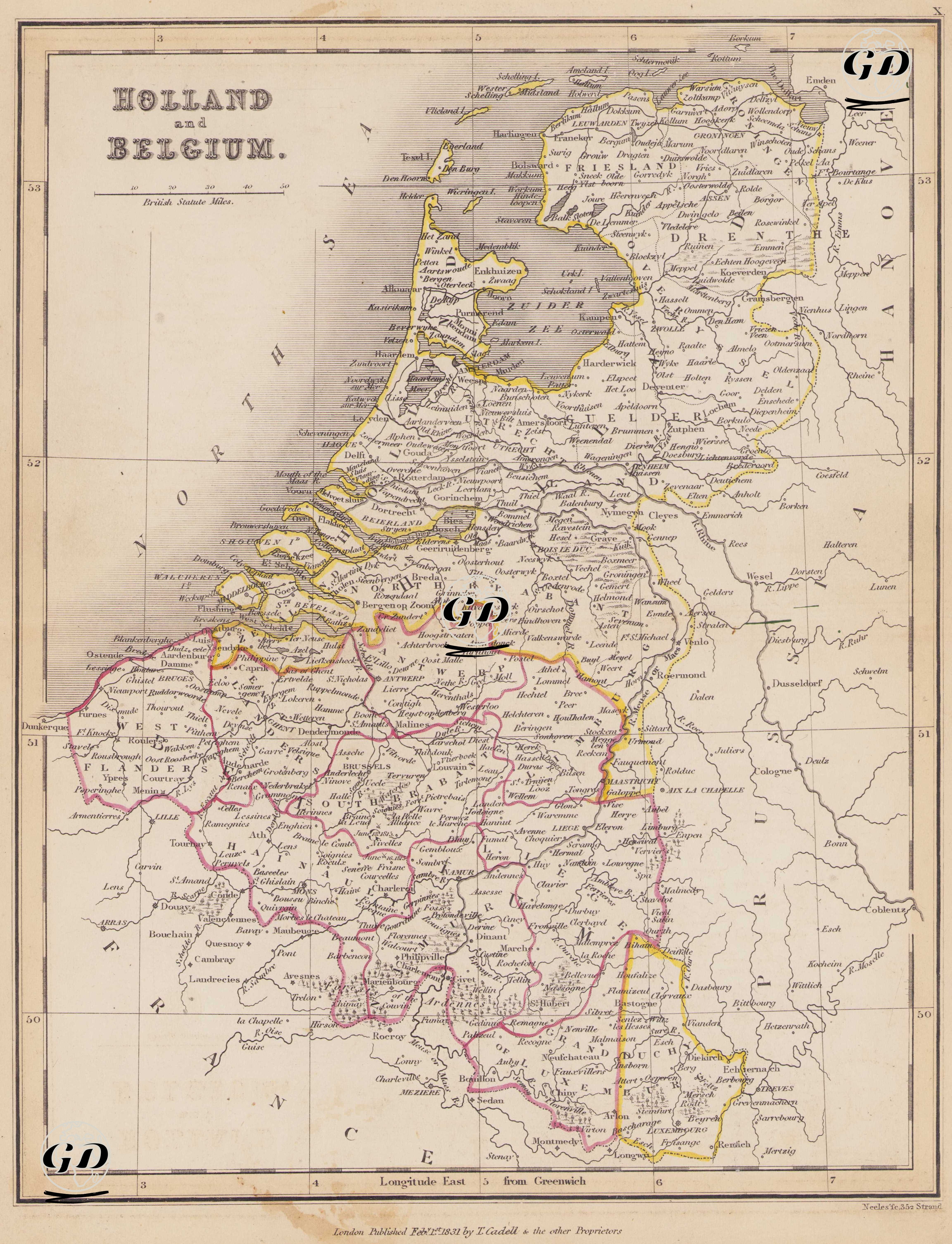
This map dated 1831 provides a detailed depiction of the political and geographical situation of the Netherlands and Belgium during the reshaping of Europe after the Napoleonic Wars. It also captures the turbulent period immediately following the Belgian Revolution of 1830, and the first traces of the Kingdom of Belgium, which had not yet gained full international recognition. The date of 1831 is crucial, as it marks the immediate aftermath of Belgium's declaration of independence but the beginning of the process in which the London Conference (1831) established definitive borders. The map provides a primary source documenting Belgium's borders with the Netherlands to the north, Prussia to the east, and France to the south. The borders with Prussia (Rhine Province) and France (Nord and Ardennes regions) are clearly marked on the map. The southern part of the map includes Belgium, which seceded from the Kingdom of the Netherlands and declared its independence following the 1830 revolution. In this historical context, the map is one of the first cartographic examples to depict Belgium's newly formed borders and administrative centers. Cities such as Brussels, Antwerp, Liège, Namur, Ghent, Bruges, Tournai, Louvain, Mons, Charleroi, and Arlon are clearly visible on the map. The map also reflects the classical regions that constituted Belgium: Flanders, Wallonie, and Brabant are highlighted with internal lines, and their administrative centers are indicated. In the northern part of the map, the cities and provinces that make up the present-day Netherlands are clearly visible. Major cities such as Amsterdam, Rotterdam, The Hague, Utrecht, Leeuwarden, Zwolle, and Groningen are clearly marked. Regions corresponding to the classical provincial structure of the Netherlands are drawn with internal borders and shown with their administrative centers. Inland seas and deltas like the "Zuyder Zee" (today's IJsselmeer) in this part of the map demonstrate the geographical importance of water management. Regional structures such as Frisia, Drenthe, Gelderland, and Brabant reflect the administrative architecture of the Netherlands in the early 19th century. Cartographically, the map is drawn to the "British Statute Mile" scale and marked with east longitudes relative to Greenwich. Landforms are indicated using the hachure (shading) technique, and city names, rivers, canals, borders, and administrative divisions are clearly depicted. Rivers such as the Maas (Meuse), Scheldt (Escaut), and Lys, with their strategic importance for transportation and industry, are also visible.