GRAVÜR DÜNYASI
Digital Engraving Library
| Engraver | Josiah Neele (1804-1876) - James Neele (active 1828-1832) |
| Date | 1831 |
| Technique | Copper Engraving-Original Hand Colored |
| Category | Maps |
| Source | London Published Feb 1 1831 by T.Cadell & the other Proprietors |
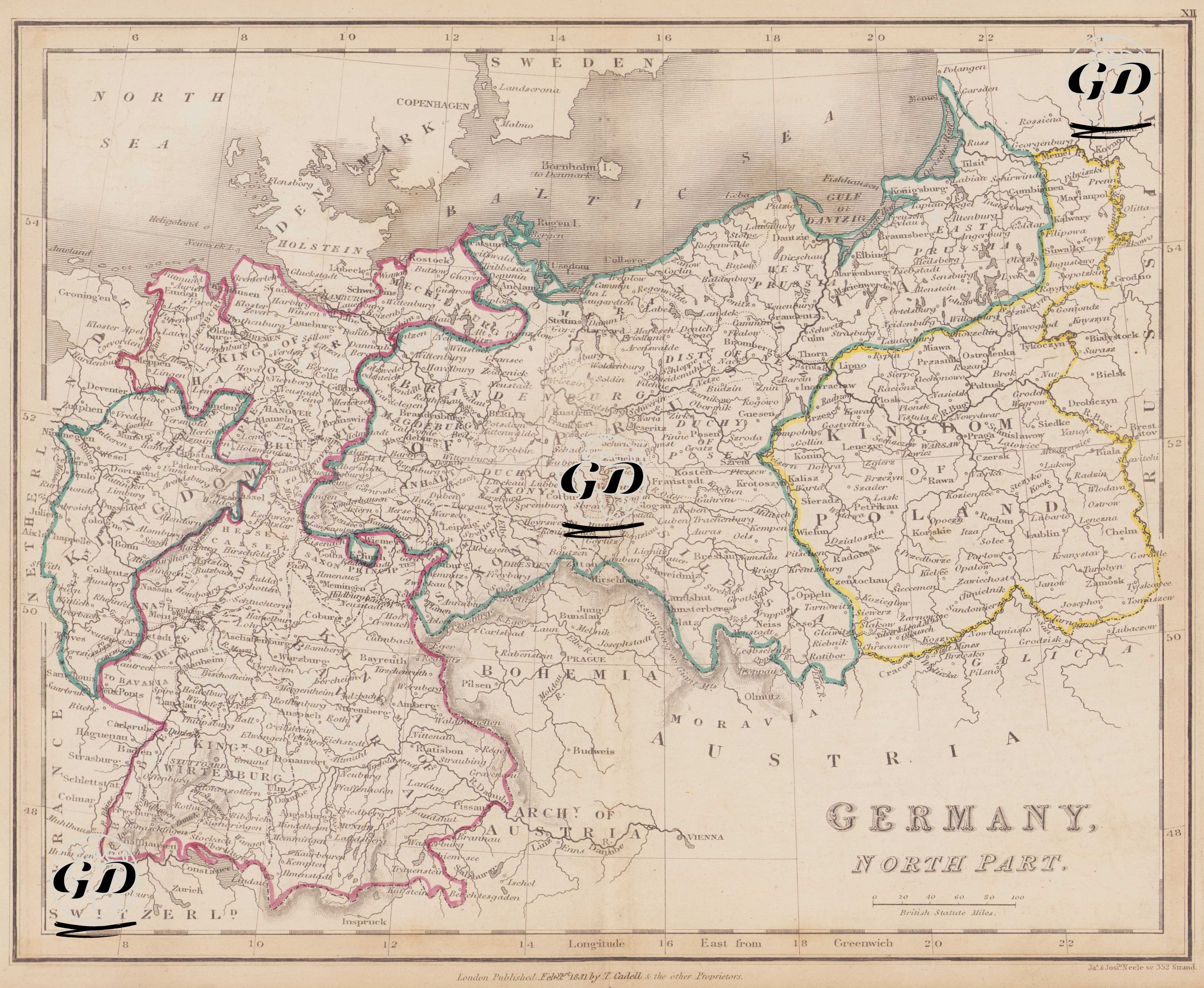
This map dated 1831 depicts a period when a modern unified Germany had not yet been established, and when German political geography possessed a polycentric, fragmented, and confederative structure. This map presents in detail the German Confederation (Deutscher Bund) system, established by the decisions of the 1815 Congress of Vienna after the dissolution of the Holy Roman Empire in 1806, and the political border network in the northern half of this system. The names of the political units written directly on the map are particularly significant in reflecting the political and administrative reality of the period. These designations are not merely labels; they also demonstrate the feudal and monarchical mosaic of the confederative German structure. In this respect, the map is not only a geographical document but also a geopolitical cartographic source depicting the political organization of the period. 1. The Kingdom of Prussia and its Dependencies: The most striking power on the map is the political entity directly designated by the phrase "Kingdom of Prussia," encompassing a vast area. During this period, Prussia stands out as one of the dominant actors within the German Confederation, with both military and bureaucratic power. It is divided into two separate geographical regions on the map, named “West Prussia” and “East Prussia”. West Prussia is located west of the Vistula River, while East Prussia (East Prussia) is located on the Baltic Sea coast, centered in Königsberg (present-day Kaliningrad) to the east. Other administrative structures affiliated with Prussia are also indicated on the map: “Duchy of Posen”: The region centered in Poznan with a large Polish population. “District of Netz” (Netze District): One of the special administrative units located between Posen and West Prussia. “Silesia”: This industrially developed region was taken from Austria in 1742 and incorporated into Prussia; it is centered in Breslau (Wrocław). 2. Other Kingdoms, Duchies and Micro-States; Kingdom of Hanover: Located in the northwest of the map; The English king also holds the title of King of Hanover. Kingdom of Saxony: A powerful monarchy centered in Dresden in East Germany. Duchy of Saxony: The general name for the small duchies that emerged from the fragmentation of historic Saxony; it includes regions such as Braunschweig (Brunswick), Saxe-Gotha, and Saxe-Weimar. Kingdom of Wirtemburg (Württemberg): Located in the southwest, its capital is Stuttgart. Kingdom of Bavaria: Located in the southeast, partially visible on the map; its capital is Munich and notable for its Catholic identity. Besides these entities, numerous smaller states such as Pomerania (a maritime region of Prussia on the Baltic coast), Mecklenburg (divided into the duchies of Mecklenburg-Schwerin and Mecklenburg-Strelitz), Hesse, Anhalt, Oldenburg, Brunswick, Lippe, Schaumburg, Waldeck, Saxe-Altenburg, Saxe-Coburg-Gotha, and Saxe-Meiningen are also clearly visible on the map. The term "Kingdom of Poland," located in the eastern part of the map, technically refers to the Kingdom of Congress Poland, established as a vassal of Russia in 1815. Although a symbolic kingdom, this region was governed by constitutional autonomy under the influence of the Russian Empire. In the north of the map, the duchies of Holstein and Schleswig were part of the Kingdom of Denmark and intertwined with the German Confederation. Bu, ileride 1864 Danimarka-Prusya Savaşı’na zemin hazırlayacaktır. Batıda haritada “Kingdom of the Netherlands” bulunmaktadır. Haritanın güneydoğusunda Archy of Austria (Avusturya Arşidüklüğü) ve Bohemia (Prag merkezli Çek toprakları) yer alır. Doğuda, Polonya’nın doğusunda Rusya İmparatorluğu bulunmaktadır. Harita, British Statute Miles ölçeğine göre hazırlanmıştır. Longitude West from Greenwich sistemine göre boylamlar işlenmiştir. Fiziksel coğrafya, dağlar ve kıyı çizgileri klasik hachure (gölgeleme) tekniğiyle gösterilmiştir.