GRAVÜR DÜNYASI
Digital Engraving Library
| Engraver | Josiah Neele (1804-1876) - James Neele (active 1828-1832) |
| Date | 1831 |
| Technique | Copper Engraving-Original Hand Colored |
| Category | Maps |
| Source | London Published Feb 1 1831 by T.Cadell & the other Proprietors |
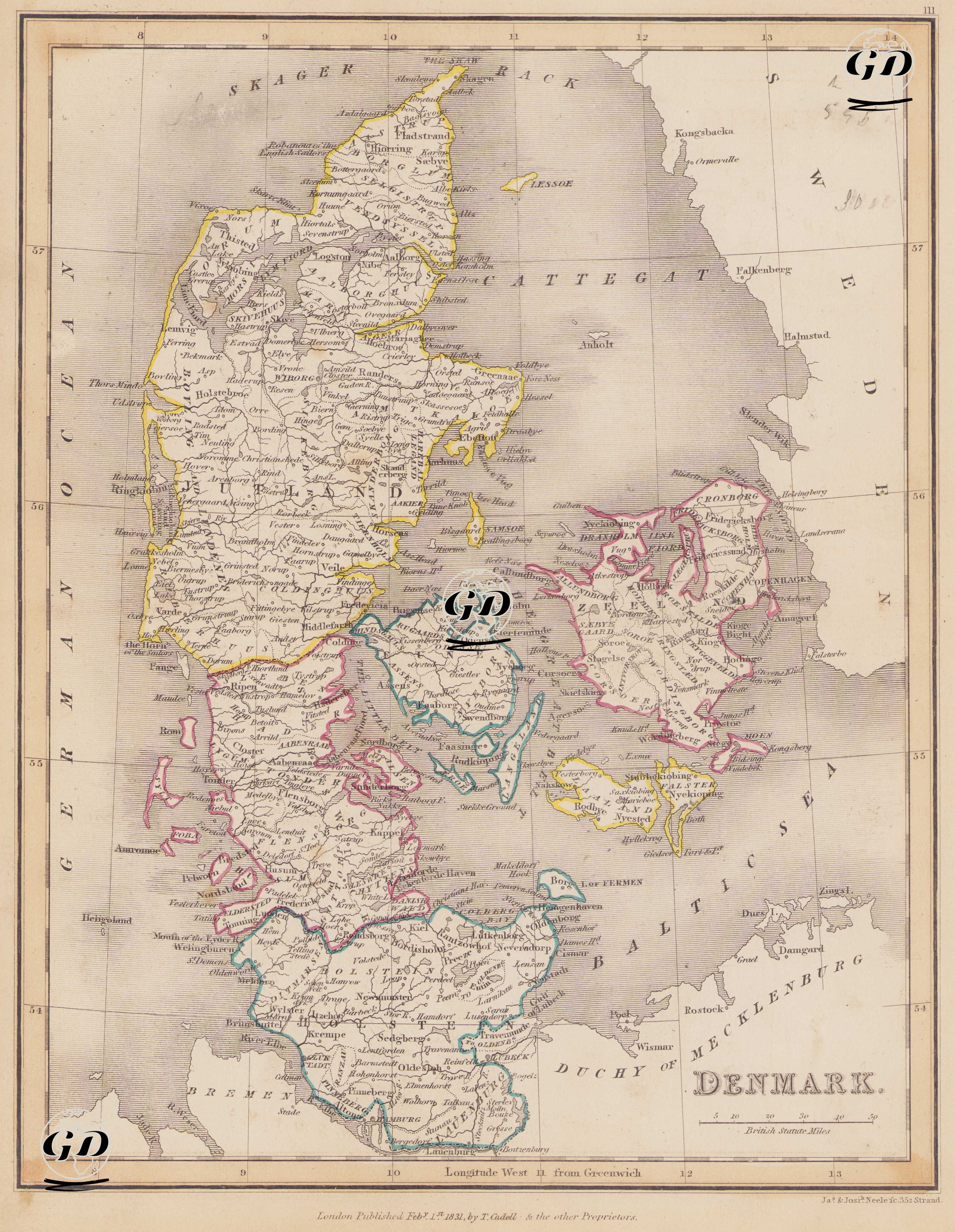
This map dated 1831 reveals not only Denmark's present-day territory but also its complex dynastic structure, its fractious borders within the German Confederation, and its strategic location between the Baltic and North Seas. The map documents Denmark's political transition as both a Scandinavian kingdom and a multinational monarchy. By 1831, the Kingdom of Denmark was a multinational monarchy, with Danes, German-speaking Holsteiners, Slavic Schleswigians, and German communities on some islands living together. The Danish king also held the titles of Duke of Schleswig, Holstein, and Lauenburg, a position that, combined with nationalist movements in the mid-19th century, would lead to major problems. The map documents this fragile political structure while it was still unresolved and reveals the geography where the seeds of the Prussian-Danish Wars were sown. The Jutland Peninsula lies in the western and northern parts of the map, comprising most of the present-day Danish mainland. From north to south, important cities such as Hjorring, Aalborg, Viborg, Ringkobing, Aarhus, Vejle, Haderslev, and Schleswig are shown. The southernmost part of Jutland contains the regions of Schleswig and Holstein, which are particularly important because they were disputed territories that caused political conflict between the German Confederation and the Kingdom of Denmark. Copenhagen, the capital of the Kingdom of Denmark, is located on the island of Zeeland. Funen (Fyn) is in the middle and also features major cities such as Odense. These two islands are the political, administrative, and economic center of Denmark. Numerous smaller islands surrounding these islands are also detailed on the map. In the south of the map, near the German border, lie the Duchies of Schleswig and Holstein. These two duchies are bordered by different colors. Schleswig, while a part of the Kingdom of Denmark, has historical and cultural ties to Holstein, a German-speaking region. Holstein is officially part of the German Confederation, but the Danish king is also duke of this region. This dual affiliation would later become one of the primary causes of the Danish-Prussian wars (1848 and 1864). These regions are highlighted on the map with separate lines (red and blue) and separated from the mainland by borders. Baltic islands such as Lolland, Falster, Møn, and Bornholm are also marked on the map. The Baltic Sea is shown in detail to the east, the North Sea to the west, and the Skagerrak and Kattegat straits to the north. Sovereignty over these waters is one of the elements that determines Denmark's historical trade power. Furthermore, Sweden is located to the east of the map, with coastal cities such as Gothenburg and Helsingborg. The territories of the German Confederation (Duchy of Mecklenburg, Lauenburg, and Lübeck) are marked to the south. The Frisian Islands to the west and the Ems River delta to the southwest indicate access routes to the German coast. The map is prepared according to the British Statute Mile scale. Longitudes are shown according to the West from Greenwich system. Physical geography, mountains and coastlines are shown using the classical hachure (shading) technique.