GRAVÜR DÜNYASI
Digital Engraving Library
| Engraver | Josiah Neele (1804-1876) - James Neele (active 1828-1832) |
| Date | 1831 |
| Technique | Copper Engraving-Original Hand Colored |
| Category | Maps |
| Source | London Published Feb 1 1831 by T.Cadell & the other Proprietors |
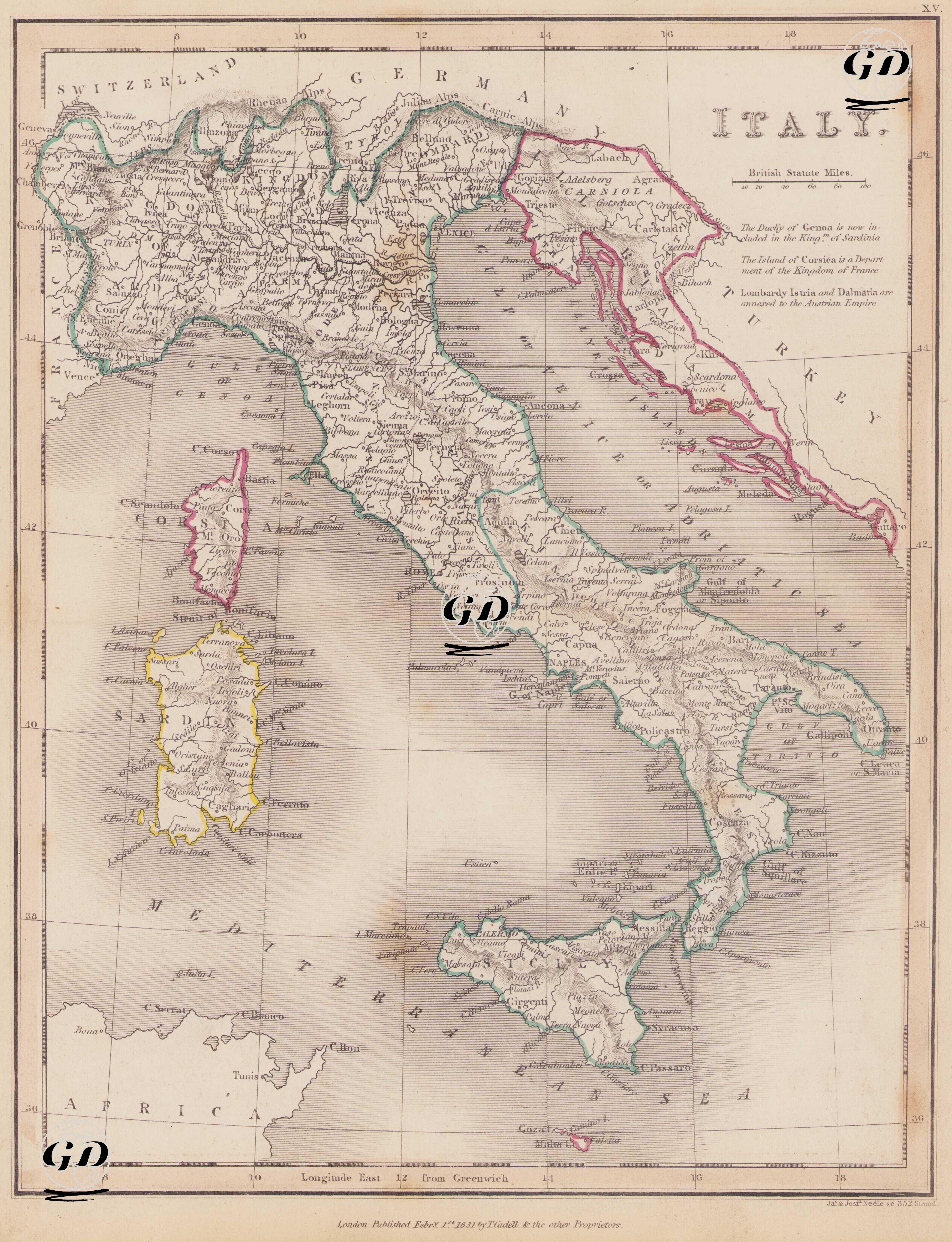
This map dated 1831 reflects the highly fragmented and polycentric political structure of the Italian peninsula, which had not yet achieved political unity. Despite the title "ITALY," the structure depicted on the map represents not a unified nation-state, but rather a multilayered political mosaic composed of various kingdoms, duchies, the papal administration, and territories controlled by foreign powers. The balance of power established in Europe after the Congress of Vienna in 1815 directly impacted Italy, and the influence of actors such as the Austrian Empire, the Kingdom of France, and the Papacy, in particular, shaped the peninsula's political identity. Three important centers of power stand out in the northern part of the map: the Kingdom of Sardinia, the Kingdom of Lombardy, and the Ecclesiastical State. The Kingdom of Sardinia encompassed both Piedmont and the island of Sardinia, with its capital in Turin. In particular, as indicated on the map by the phrase “The Duchy of Genoa is now included in the Kingdom of Sardinia”, the previously independent Duchy of Genoa was annexed to the Kingdom of Sardinia from 1815 onwards. This was a turning point in the strengthening of Sardinia, which would spearhead the Risorgimento, the Italian unification movement, in the years to come. Lombardy, located east of Sardinia, was designated the "Kingdom of Lombardy" on the map and shown as part of the Austrian Empire. This region, in fact, came under Habsburg rule as the "Lombardo-Venetian Kingdom" from 1815 onwards. The note on the map, "Lombardy, Istria, and Dalmatia are annexed to the Austrian Empire," further confirms the accuracy of this annexation. Strategic regions such as Milan, Venice, Trieste, and the Dalmatian coast symbolize Austria's Adriatic dominance and influence in Italy. Furthermore, the fact that Istria and the Dalmatian coast are shown as directly belonging to Austria in the northeast of the map provides cartographic evidence of this sovereignty. In central Italy, the Papal State, defined as the "Ecclesiastical State" and clearly marked on the map, encompassed a vast area stretching from Bologna to Rome. This region was a theocratic state governed not only spiritually but also temporally by the Pope. During the unification of Italy, particularly after 1860, the Papal State faced Italian nationalism and was ultimately abolished in 1870 when Rome was incorporated into the Kingdom of Italy. While Southern Italy appears on the map as two distinct geographical units: the Kingdom of Naples (Mainland) and the Kingdom of Sicily (Island), these regions were a single, unified kingdom ruled by the Bourbon Dynasty under the name "Kingdom of the Two Sicilies." While economically prosperous, these lands were politically absolutist and less modernized than the constitutional monarchies to the north. Sardinia, located in the west of the map, is, as mentioned above, part of the Kingdom of Sardinia and is outlined in yellow. Sicily, bordered in green and, along with Naples to the south, reflects Bourbon sovereignty. The island of Corsica, located in the northwest of the map, is described with the phrase "The Island of Corsica is a Department of the Kingdom of France" and is accordingly defined as an administrative region of France. This region was ceded from Genoa to France in 1768, and this is clearly stated on the map. The Albanian and Greek coasts of the Ottoman Empire are marked in the east of the map with the word "TURKEY," demonstrating the continued Ottoman influence on the eastern shores of the Adriatic. Similarly, coastal regions such as Istria and Dalmatia reflect the historical legacy of the Ottoman-Austrian conflict. Technically, the map uses the British Statute Miles, and longitude is plotted according to the Longitude East from Greenwich system. The physical geography is presented using hachure (linear shading), a common cartographic method of the time, and mountain ranges and coastal contours are meticulously rendered. Important cities (Turin, Milan, Rome, Naples, Florence, etc.) and historical centers are also clearly marked on the map.