GRAVÜR DÜNYASI
Digital Engraving Library
| Engraver | Josiah Neele (1804-1876) - James Neele (active 1828-1832) |
| Date | 1831 |
| Technique | Copper Engraving-Original Hand Colored |
| Category | Maps |
| Source | London Published Feb 1 1831 by T.Cadell & the other Proprietors |
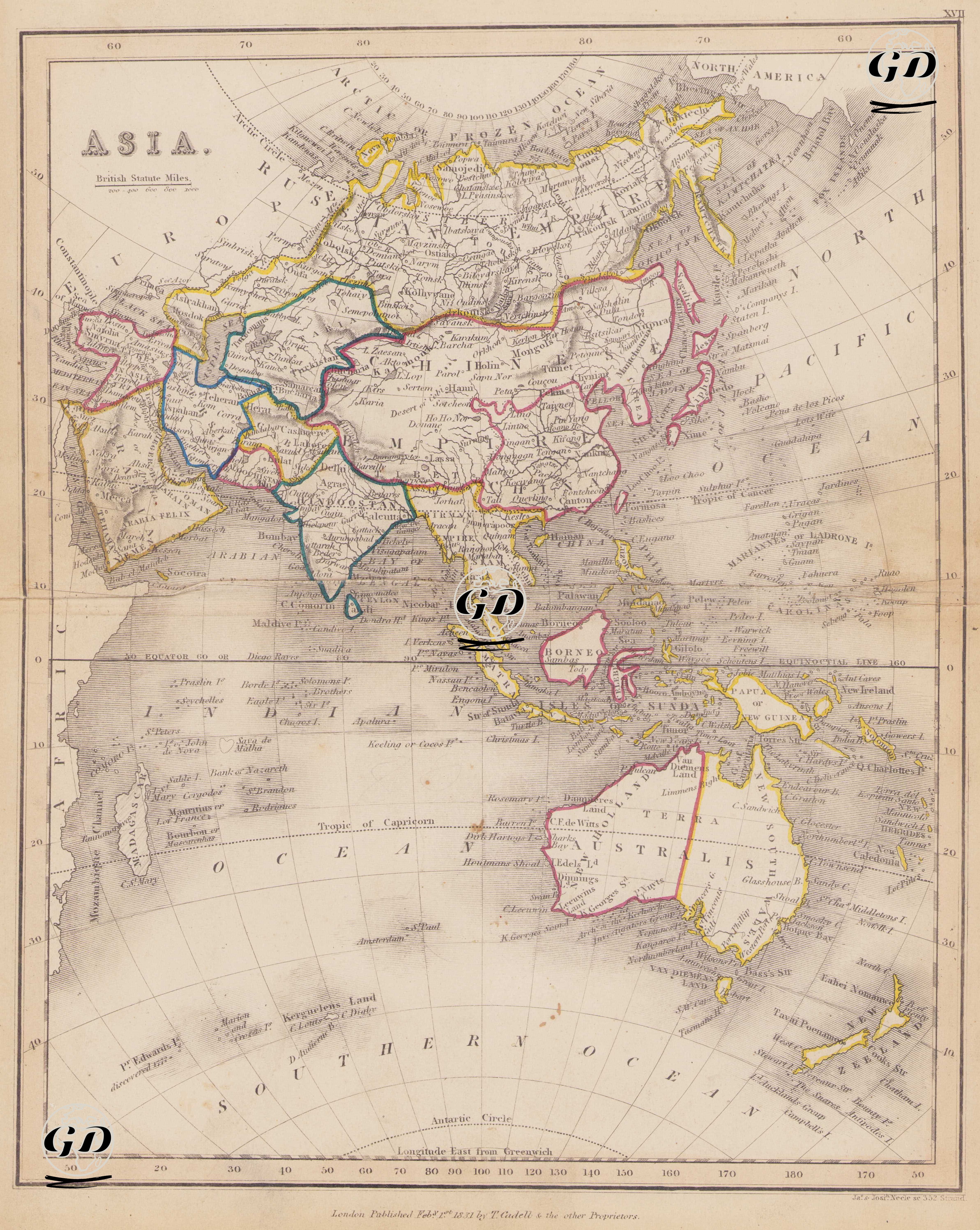
This map dated 1831 presents the entire Asian continent and its islands from a European perspective, revealing a multilayered geographic-political structure comprised of empires, sultanates, and colonies. In this historical context, the map not only provides a physical view but also clearly demonstrates the areas of sovereignty over the continent held by the great powers of the time: Tsarist Russia, the Qing Dynasty, the Ottoman Empire, the British East India Company, the Persian (Qajar) Dynasty, the Tokugawa Shogunate of Japan, and the Dutch Colonies. Britain dominated India and Southeast Asia; Russia dominated Siberia and Central Asia; China, on the other hand, sought to maintain its traditional borders; while the Ottomans and Iranians maintained defensive positions along their borders. The Chinese Empire encompasses a vast area marked by pink lines on the map. China's historical claims of sovereignty over inland regions, Manchuria, Mongolia, and Tibet are shown within these boundaries. Korea and the Loo-Choo Islands are also indicated as being under Chinese influence. Tsarist Russia (Russia in Asia) extends from the Ural Mountains in the north to the Pacific with yellow lines. Both European and Asian parts are shown combined under the heading "Russia" on the map. The Indian subcontinent and its surrounding areas, under British Influence (Hindostan), are outlined with green and blue lines. Regions such as Bengal, Madras, Bombay, and Sindh were under direct British control or protectorate. Parts of Burma and Ceylon (Sri Lanka) also belonged to Britain. The Persian Empire, or Iran, is shown with a green line. This corresponds to the Qajar Dynasty. The Ottoman Empire (Turkey in Asia) is shown with yellow lines in the west of the map, including the present-day Middle East. The northern and western regions of Anatolia, Mesopotamia, Damascus, and Arabia are shown under Ottoman rule. The Dutch East Indies and the islands of present-day Indonesia are separated by a pink border. Java, Sumatra, Celebes, Borneo, and the Moluccas are marked as Dutch colonies. The Australian continent (New Holland/New South Wales) appears to be completely unexplored, with distinct eastern and western borders. "New South Wales," under British colonization, is featured on the map, and "Unexplored" is marked in the interior. Parts of Alaska (still part of Russia) are drawn in the upper right corner of the map. Africa and Europe are shown in the upper and lower left corners, and their borders with Asia are defined. Japan is marked with a pink line. Tokugawa-era Japan, not yet fully expanded to the west, appears to have an independent and closed structure on the map. The equator and Tropic of Cancer are clearly marked on the map, and the tropical and temperate zones of Asia are marked. Geographical features such as deserts, mountains, rivers, and lakes are depicted using shading and the classic hachure (linear relief) technique. Longitude was measured according to the Longitude East from Greenwich system and “British Statute Miles” was used as the scale.