GRAVÜR DÜNYASI
Digital Engraving Library
| Engraver | Josiah Neele (1804-1876) - James Neele (active 1828-1832) |
| Date | 1831 |
| Technique | Copper Engraving-Original Hand Colored |
| Category | Maps |
| Source | London Published Feb 1 1831 by T.Cadell & the other Proprietors |
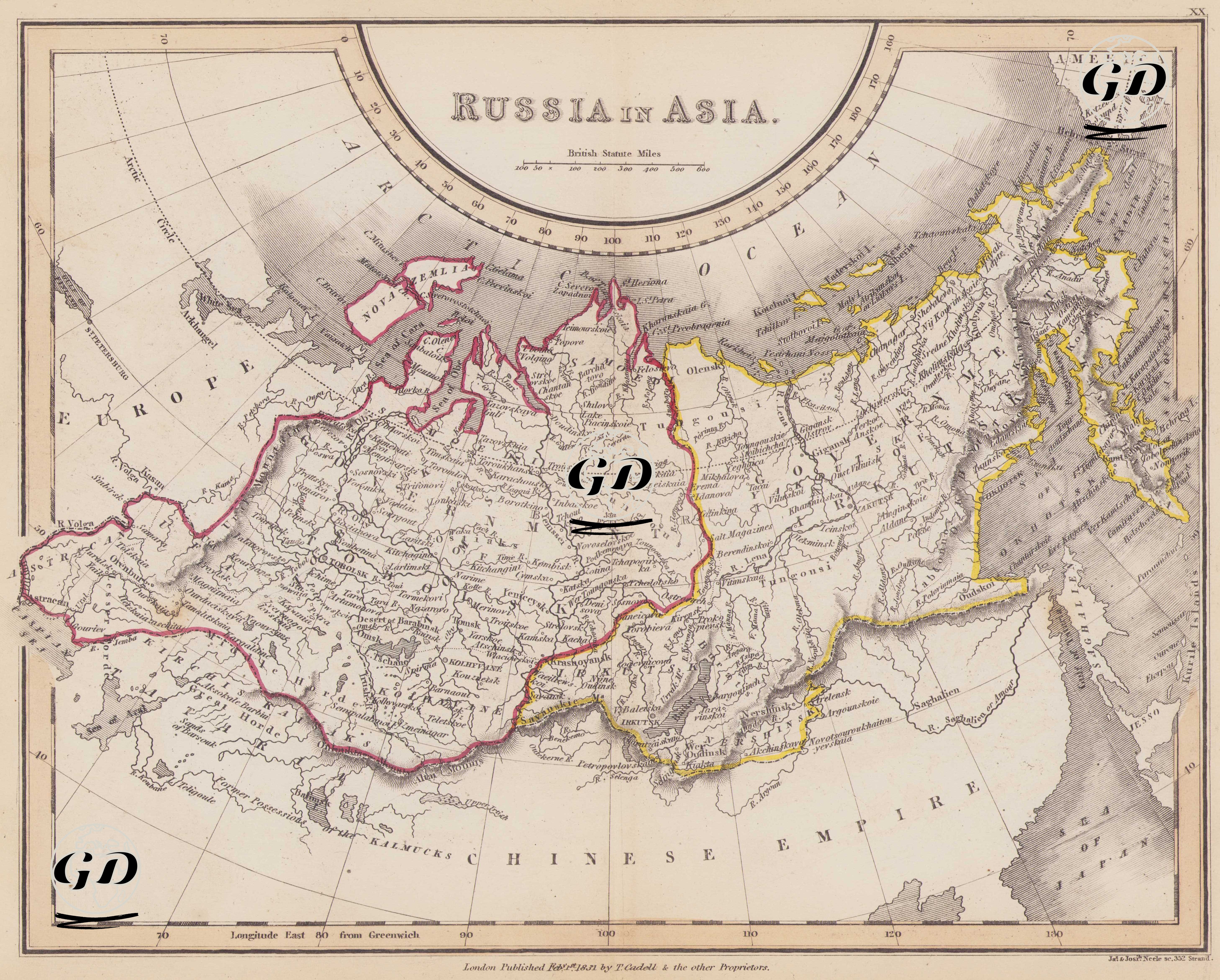
This map dated 1831 presents Tsarist Russia's dominance in Asia and the administrative structure it established across this vast region from a Western perspective. The upper part of the map extends to the Arctic Circle, while to the east lies the Pacific Ocean, and to the west lies the eastern Ural Mountains and the eastern borders of the Caucasus. In the south, the map focuses on Russia's strategic lines surrounding the Chinese Empire, India's northern borders, the Central Asian Khanates, and the Caspian Sea. The map encompasses approximately 9,000 kilometers of Russian territory. This geography reflects the first half of the 19th century, a period when the Russian Empire consolidated its geopolitical influence in Eurasia as one of the largest land empires, and the map is a visual reflection of this historical context. The colored lines on the map demarcate the empire's internal administrative structure and its external borders. Two particularly striking administrative areas are the "Government of Tobolsk" (red border) and the "Government of Irkutsk" (yellow border), clearly labeled on the map. The term "government" in these terms refers not to the central government in its modern sense, but to the "gubernia" system employed by Tsarist Russia; these regions were large regional administrative units governed by governors (gubernators) directly appointed by the tsar. Tobolsk Governorate was the western gateway to Siberia and, from the 18th century onward, the center of Russia's colonization of Asia; it served as a strategic gateway to the Kazakh steppes, the Urals, and the northern Caspian Sea. Irkutsk Governorate, on the other hand, encompassed the area around Lake Baikal and Eastern Siberia, and its proximity to the Chinese border and Mongolia made it important for trade, diplomacy, and military mobility. Numerous cities and administrative centers are shown on the map: Tobolsk, Omsk, Tomsk, Barnaoul, Krasnoyarsk, Irkutsk, Yakutsk, Okhotsk, Petropavlovsk, Verkhoyansk and other settlements are parts of the transportation, supply and control network that the Russians created in this vast geography. To the east, the map depicts the Kamchatka Peninsula on the Pacific coast; to the north, Novaya Zemlya Island and the near-polar tundra; to the south, the Caspian Sea, the eastern Caucasus, the passages to Central Asia, and the border with China. The map also includes the label Nova Archangelsk (present-day Sitka, Alaska), marking Russia's colonial presence in the Americas (Russian Alaska) in the 1830s. In terms of natural elements, the map shows in detail major rivers such as the Ob, Yenisei, Lena, and Amur, as well as physical features such as the Ural Mountains, the Altai Mountains, Lake Baikal, and the Kamchatka Volcanic Mountains, using the classic "hachure" (shading) technique. The Chinese Empire is marked on the southern border, Europe to the west, the Arctic Ocean to the north, and the Pacific Ocean and the coasts of Japan to the east. At the center of the map is Siberia, a vast landmass. Published in 1831, this map demonstrates that Tsarist Russia was not merely a land empire but also a power striving for maritime access, shaping the geopolitical balance of Asia. Russia's eastern Siberian regions bordering China, the passages to Central Asia, the Caucasus, the Caspian Sea, and the Baltic and Arctic reaches are brought together within a broad geographical framework on this map. In this respect, the "Russia in Asia" map provides a powerful visual for understanding not only geographical borders but also imperial vision, administrative structure, and expansionist strategy.