GRAVÜR DÜNYASI
Digital Engraving Library
| Engraver | Josiah Neele (1804-1876) - James Neele (active 1828-1832) |
| Date | 1831 |
| Technique | Copper Engraving-Original Hand Colored |
| Category | Maps |
| Source | London Published Feb 1 1831 by T.Cadell & the other Proprietors |
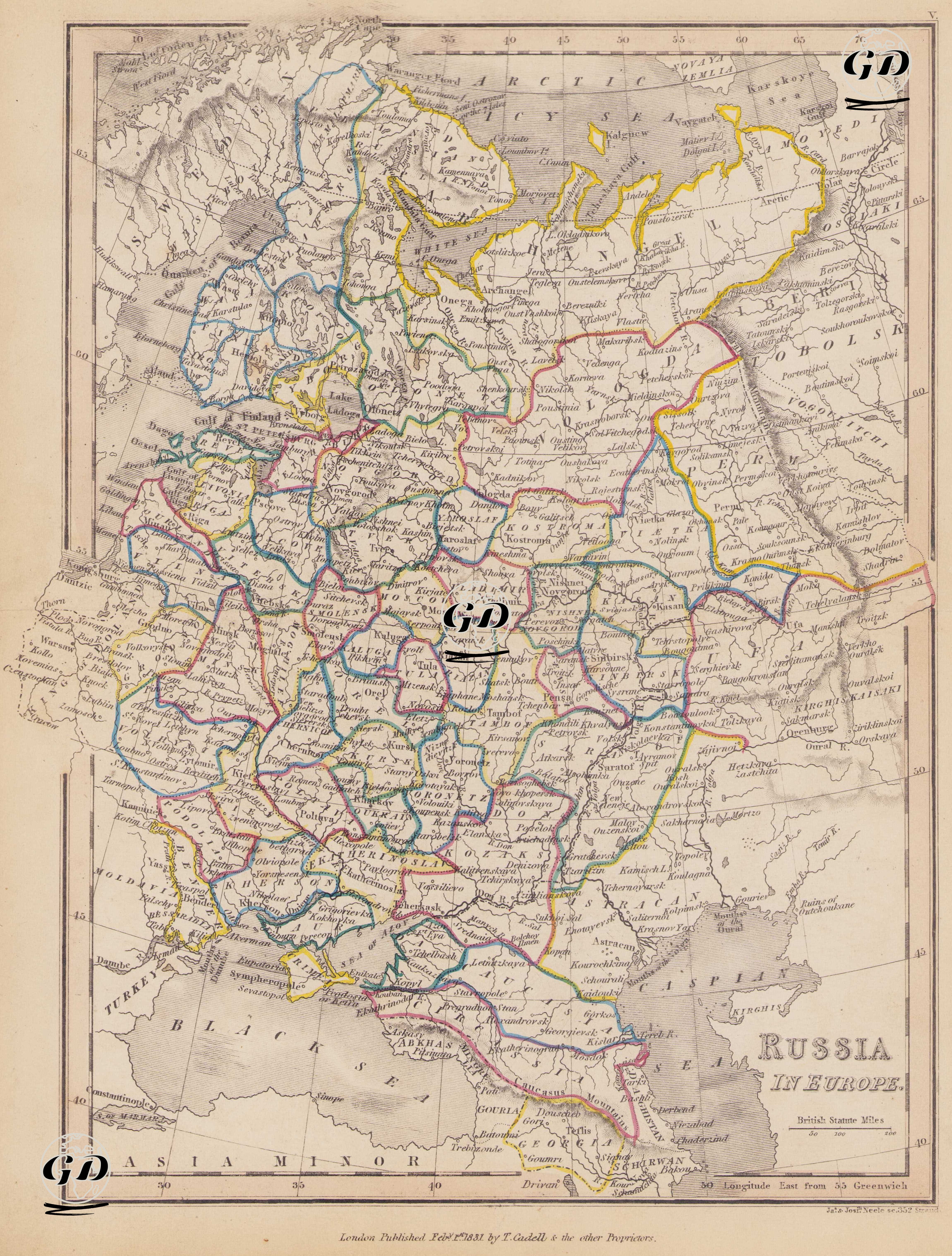
This map dated 1831 is a detailed political map reflecting Tsarist Russia's borders, administrative divisions, and neighboring relations on the European continent. The map encompasses present-day Russia, Ukraine, Belarus, Moldova, the Baltic states, eastern Poland, Finland, and parts of the Caucasus. 1831 was a period of active expansion and fortification for the Russian Empire on both its western and southern borders. Territories seized from Sweden in the Baltic Sea, territories annexed in the Black Sea during wars with the Ottoman Empire, and victories against Iran and the Ottoman Empire in the Caucasus shaped the formation of the map's borders. At the same time, the 1830-31 uprising in Poland was suppressed, a significant political event coinciding with the year the map was published. This map reflects both Tsarist Russia's administrative organization and its expansion strategies in Europe. The map shows the gubernia (province) system in the European part of the Russian Empire, with colored borders. Cities such as the capital St. Petersburg, Moscow, Kharkiv, Odessa, Tula, Smolensk, Kazan, Astrakhan, Tiflis (Tbilisi), Vilna, Riga, Minsk, and Poltava were important administrative and military centers of the period. To the west, it encompassed parts of Poland (not yet fully independent; after the Congress of Vienna in 1815, it continued its existence as the "Kingdom of Poland" under Russian auspices); to the north, Finland (acquired from Sweden in 1809 and incorporated into Russia. It is located on the Baltic coast on the map); to the south, the Black Sea coast (especially Odessa and the Crimean Peninsula, forming Russia's line of contact with the Ottoman Empire. The annexation of the Crimean Khanate in 1783 laid the foundation for this line); and the eastern border ended around the Volga. Tbilisi, Yerevan, and their surrounding areas were incorporated into Russia's southern border following the Ottoman-Iranian wars at the beginning of the 19th century. The map shows detailed major river systems, including the Dnieper, Don, Volga, Neva, and Dniester, which are important for both trade and defense. Water bodies such as the Black Sea, the Sea of Azov, the Caspian Sea, the Baltic Sea, and the Gulf of Finland are shown in detail. The map is based on the "Longitude East from Greenwich" measurement system, with the scale unit being "British Statute Miles." Mountainous areas are shown using the classic "hachure" shading method.