GRAVÜR DÜNYASI
Digital Engraving Library
| Engraver | Josiah Neele (1804-1876) - James Neele (active 1828-1832) |
| Date | 1831 |
| Technique | Copper Engraving-Original Hand Colored |
| Category | Maps |
| Source | London Published Feb 1 1831 by T.Cadell & the other Proprietors |
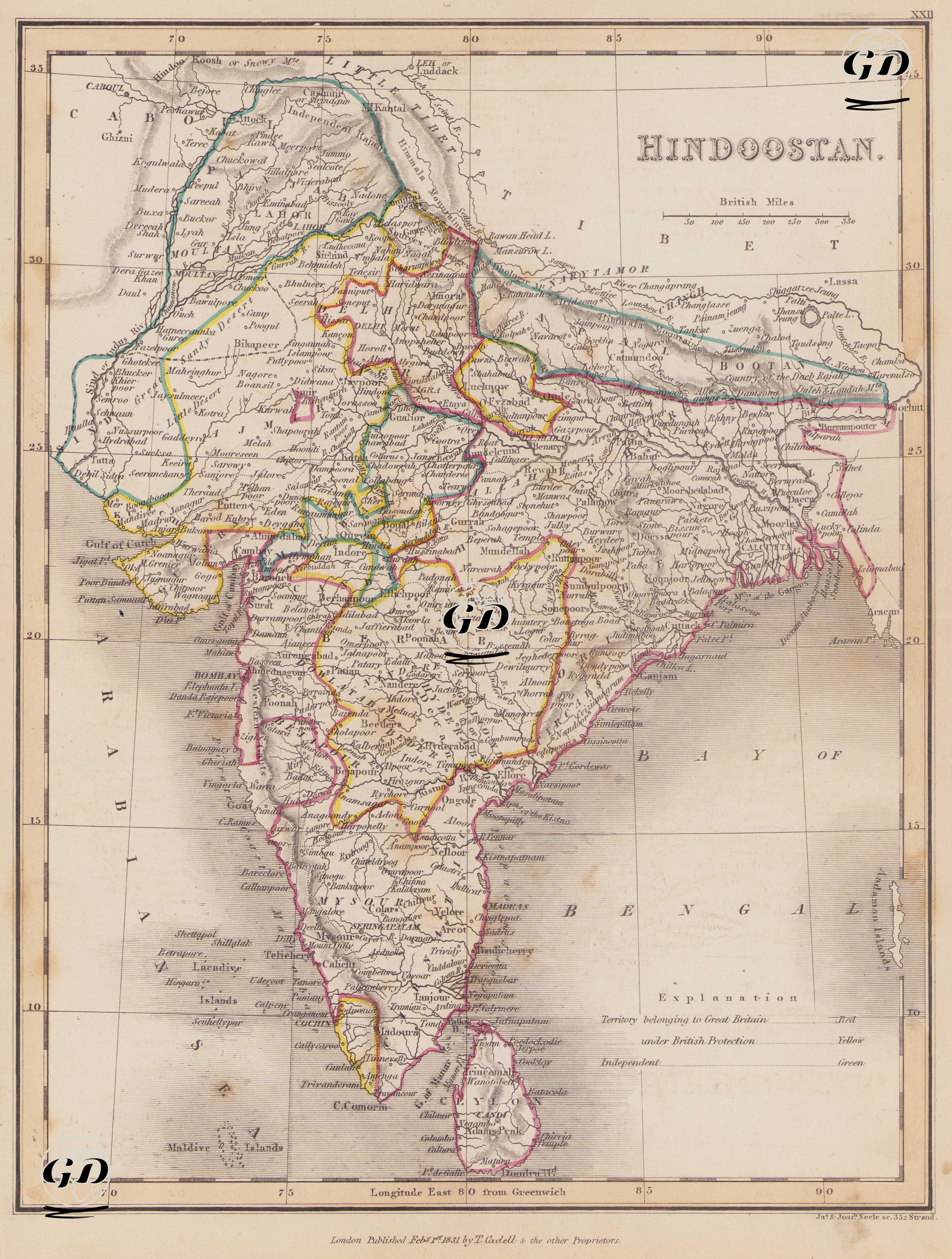
This map dated 1831 presents the political, administrative, and geographical structure of the Indian subcontinent, particularly within the context of the British Empire's colonial expansion. The map encompasses not only present-day India but also neighboring regions such as Pakistan, Bangladesh, Nepal, Bhutan, Sri Lanka, and the eastern part of Afghanistan. 1831 was a transitional period during which Britain increasingly centralized its control over India. While the East India Company remained influential in the administration, the political control of the British crown was strengthening. With the dissolution of the Maratha Confederacy between 1818 and 1830, many northwestern principalities became either direct British territory or became protectorates. This map can be considered the most comprehensive map of colonial development prior to the Sepoy Mutiny of 1857. According to the legend in the lower right corner: 1. Red Bordered Areas (Territory belonging to Great Britain - Territories directly belonging to the British Empire); Bombay Presidency (West India coast, parts of present-day Maharashtra and Gujarat), Madras Presidency (South India - Tamil Nadu, Andhra coast), Bengal Presidency (centered on Calcutta; Bengal, Bihar, Orissa) and Sri Lanka (Ceylon) 2. Yellow Bordered Areas (Under British Protection - Principalities, allied or protectorate native dynasties); These areas were geographies where autonomous native administrations (mostly ruled by radjas and nizams) pledged allegiance to Britain and maintained an independent existence in their internal affairs but under British guidance in foreign policy. (Hyderabad, Mysore, Travancore, Gwalior, Jaipur, Jodhpur, Bhopal, Baroda, many small principalities in the Rajputana region) 3. Green Bordered Regions (Independent - Regions considered independent); Nepal, Bhutan, the Tibetan plateau and Ladakh region, parts of which are marked as "Independent", eastern Afghanistan (Kabul, around Ghazni). The Himalayas, the Tibetan Plateau, and the Karakoram passes are clearly shown on the map using mountain shading. River systems such as the Indus, Ganges, Godavari, Krishna, and Cauvery are detailed, and important port cities such as Bombay (Mumbai), Madras (Chennai), and Calcutta (Calcutta) are shown. Neighboring islands such as the Maldives, Ceylon (Sri Lanka), and the Andaman Islands are systematically plotted. The map is scaled in British Miles, and lines of longitude are given according to the "Longitude East from Greenwich" system.