GRAVÜR DÜNYASI
Digital Engraving Library
| Engraver | Josiah Neele (1804-1876) - James Neele (active 1828-1832) |
| Date | 1831 |
| Technique | Copper Engraving-Original Hand Colored |
| Category | Maps |
| Source | London Published Feb 1 1831 by T.Cadell & the other Proprietors |
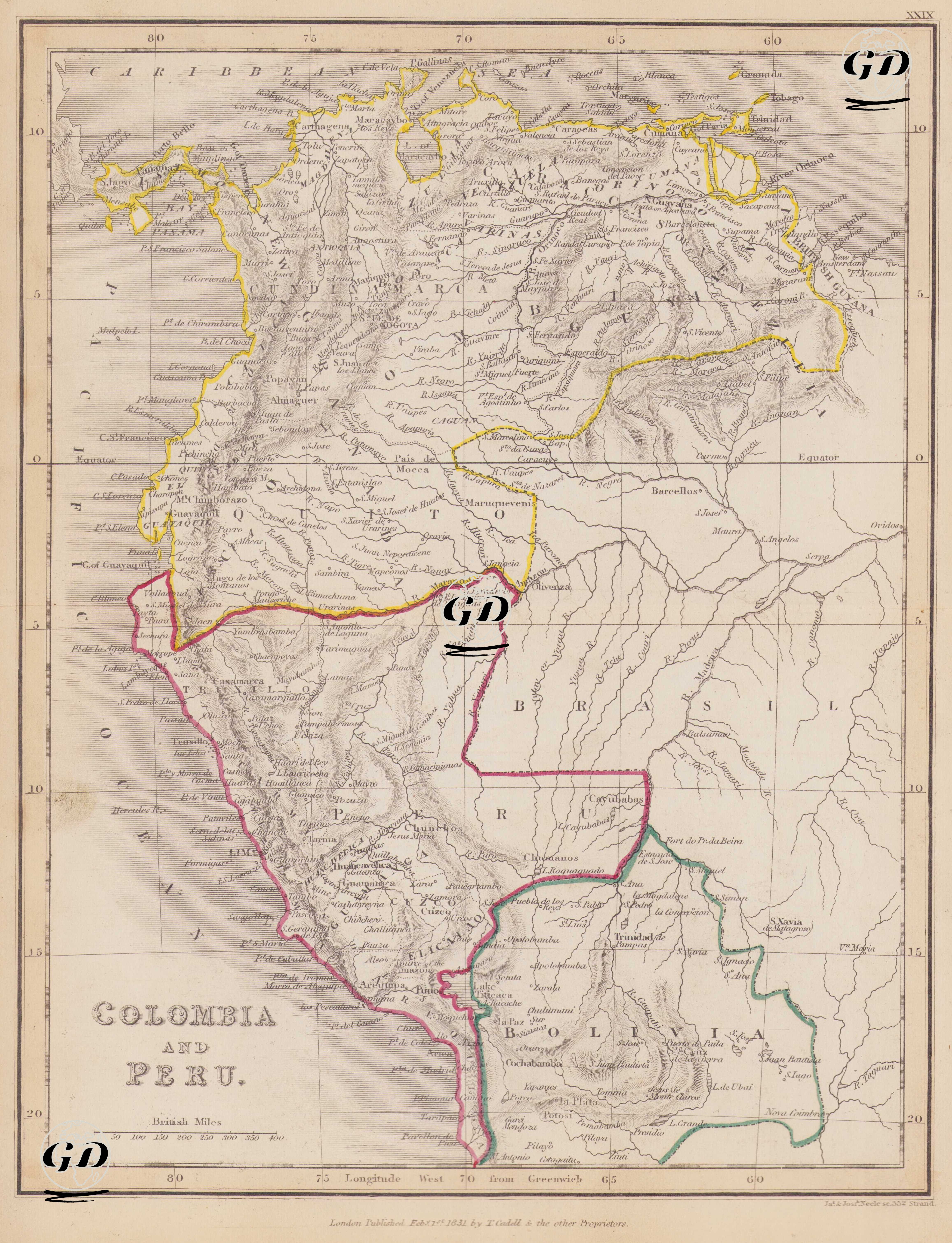
This map dates from 1831 and is identified by the phrase "Colombia and Peru." It depicts the northwestern region of South America, encompassing a large portion of the region, primarily Colombia, Peru, Ecuador, Venezuela, Bolivia, and Brazil. It is an important cartographic source documenting how the post-independence political landscape of Latin America was perceived through Western European eyes in the first half of the 19th century. The colored borders on the map represent different independent or administrative entities. The designations are in accordance with the prevailing usage of the time; Colombia (Colombia/Nueva Granada) is shown with the yellow border. It encompassed most of present-day Colombia, northern Ecuador, and western Venezuela. Its capital was Santa Fé de Bogotá (present-day Bogotá), and its major cities included Cartagena, Medellín, Popayan, and Quito. Before 1830, it was a unified federation called Gran Colombia, but it effectively disintegrated in 1831. This map was produced shortly after the dissolution process. Peru, shown with a red-and-pink border, represents the Republic of Peru, which declared independence in 1821 and gained complete liberation from the Spanish in 1824. The map highlights the first decade of the independent Republic of Peru. Lima is the capital of the region encompassing the western coast and interior of present-day Peru, and cities such as Cuzco, Arequipa, Trujillo, and Puno are prominent. Bolivia, bordered in green, is a young republic founded in 1825 with the support of Bolivar and encompasses most of its modern borders. Cities such as La Paz, Cochabamba, and Trinidad are prominent. Brazil, marked with pink borders on the map, expanded into the Amazon basin and declared independence from Portugal in 1822, which was recognized in 1825. The country's name is written as "BRASIL" on the map, and its territory is shown extending eastward. The map shows in detail not only political boundaries but also major river systems such as the Amazon, Magdalena, and Orinoco, mountain ranges (especially the Andes), and lake systems (such as Lake Titicaca); topographical elements are rendered using classical volumetric shading. Most place names retain their Spanish forms, while the British Mile is used as the measurement system, and longitude is based on Greenwich.