GRAVÜR DÜNYASI
Digital Engraving Library
| Engraver | Josiah Neele (1804-1876) - James Neele (active 1828-1832) |
| Date | 1831 |
| Technique | Copper Engraving-Original Hand Colored |
| Category | Maps |
| Source | London Published Feb 1 1831 by T.Cadell & the other Proprietors |
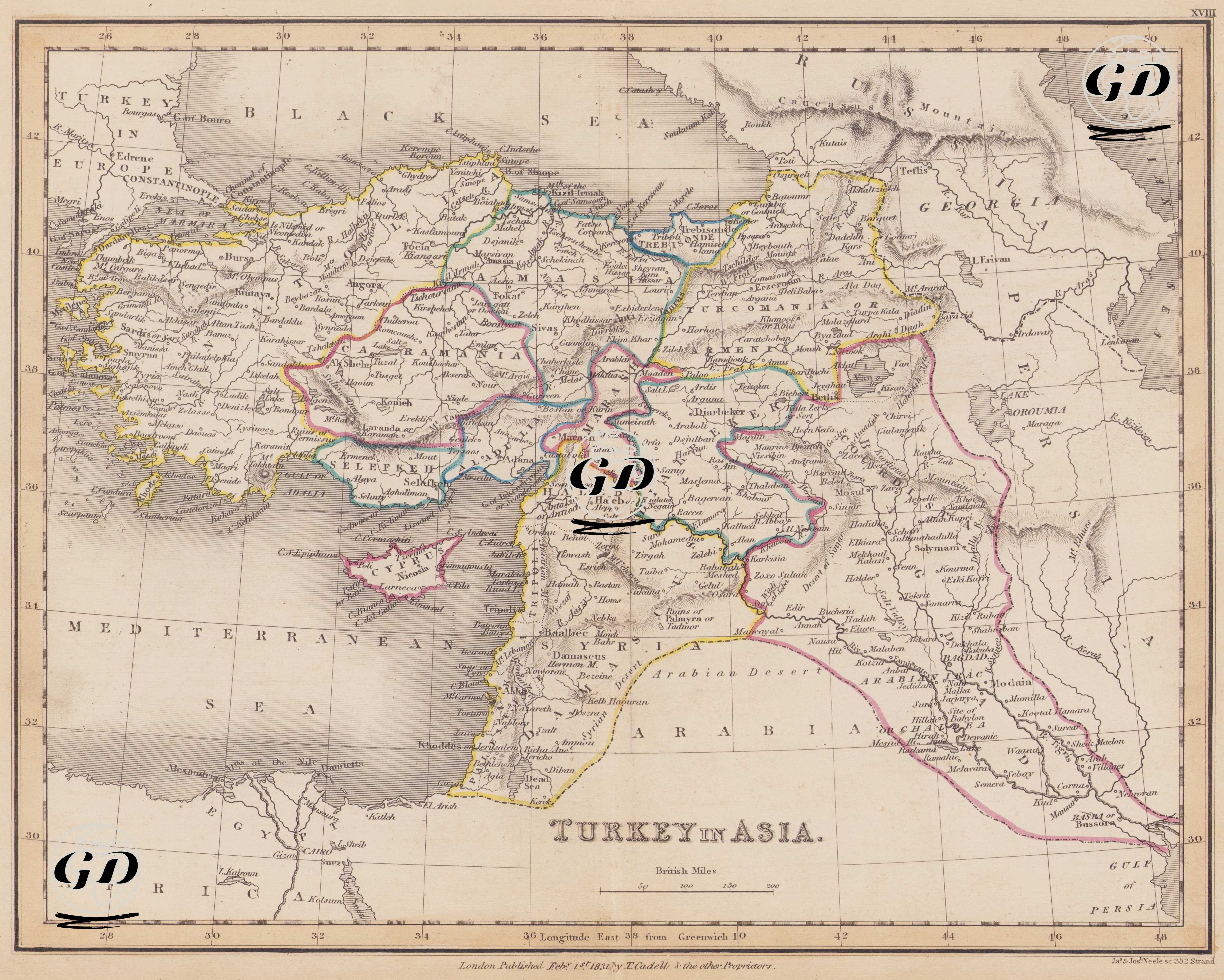
This map, dated 1831 and titled "Turkey in Asia," is a political map encompassing the Ottoman Empire's territories in Asia. The term "Turkey in Asia" was a common term used by European cartographers of the period to distinguish the Ottoman Empire's territories in Asia from those in Europe. Within this framework, the map includes Anatolia (Asia Minor), the Levant (the Syrian-Palestinian coasts), Mesopotamia, Northern Arabia, Eastern Anatolia, and the regions extending to the Iranian border. The map shows the provincial (vilayet/sanjak) borders of the Ottoman Empire at that time, using different color schemes. Some of these provinces, according to the map, include Anatolia, Caramania, Amasia, Marash, Selefkeh, Aladulia, Aleppo, Diarbeker, and Baghdad. These divisions reveal the internal administrative structure of the empire at the beginning of the 19th century. At the same time, most of the place names on the map are written in English transcription (e.g. Smyrna - Izmir, Erzeroum - Erzurum, Scandaroon - Iskenderun, Aleppo - Aleppo, Baghdad - Baghdad). The date 1831 also coincides with the outbreak of the Egypt-Syria crisis between Kavalalı Mehmed Ali Pasha and the Ottoman central administration. In this context, the map's relation to the Syrian coast, the Nile Delta, and the Arabian Desert is also significant. Locations such as the mouth of the Nile River, Cairo, and Memphis are marked in the lower left corner of the map, and Egypt is included in the Ottoman hinterland further down the map. The map also boasts rich physical geography. Major geographical elements such as the Euphrates and Tigris rivers, the Taurus Mountains, the Zagros range, the Anatolian plateau, the Mesopotamian plain, and the Arabian Desert are accurately positioned. In the map's drawing, elevations and mountainous areas are marked using the hachure method. Geographic boundaries are outlined in different colors, and border relations with neighboring regions such as Iran (Persia), Arabia, and Georgia are carefully illustrated. The phrase "Longitude East from Greenwich" is included at the bottom; This indicates that the map was prepared according to British standards and was based on measurements centered at Greenwich. The scale used on the map is also indicated as "British Miles."