GRAVÜR DÜNYASI
Digital Engraving Library
| Artist | Alexander Keith Johnston (1804-1871) |
| Engraver | William Johnston (1802-1888) |
| Date | 1848 |
| Technique | Steel Engraving-Original Hand Colored |
| Category | Maps |
| Source | Atlas Alison's History Of Europe By Alexander Keith Johnston - William Blackwood & Sons, Edinburgh & London |
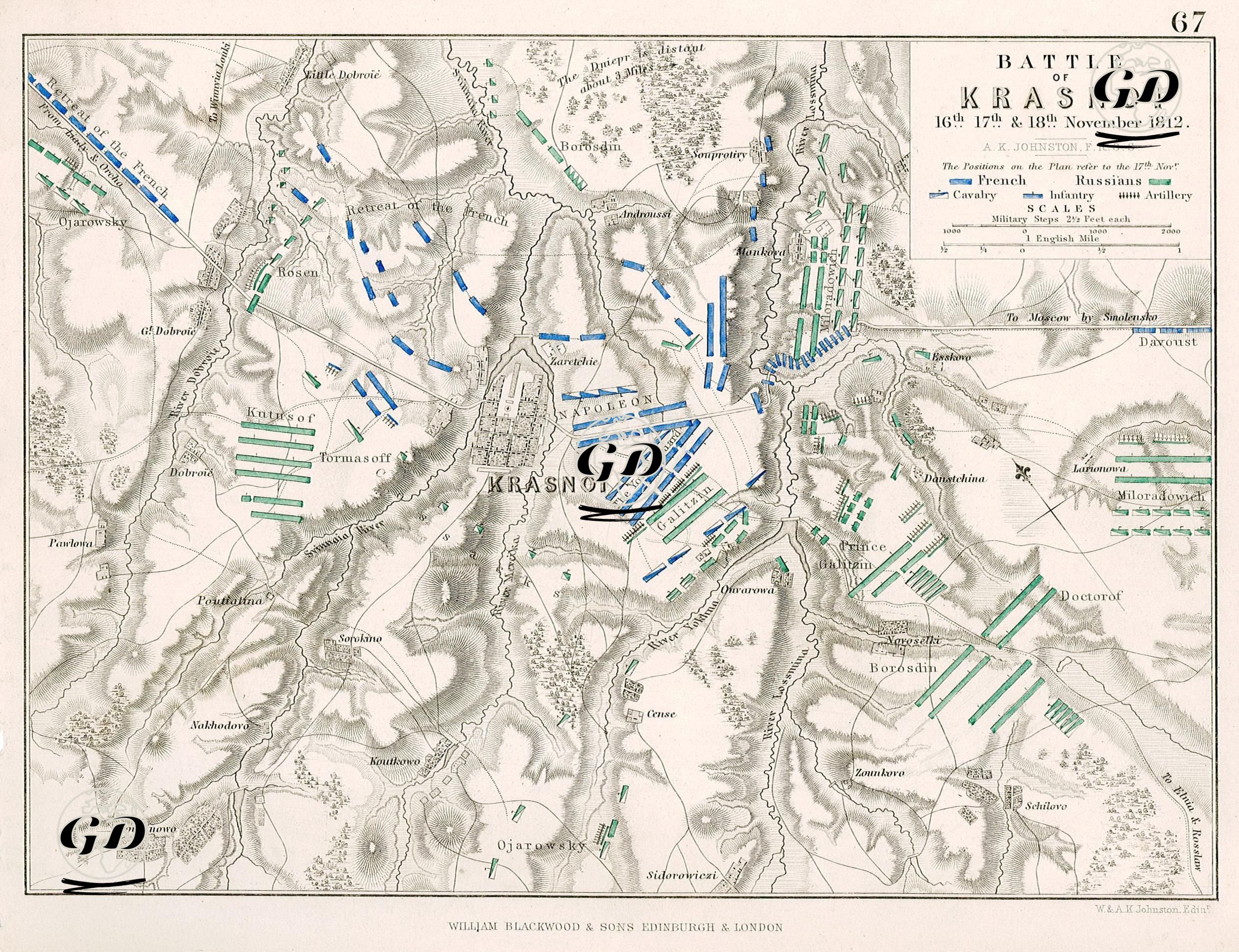
This map visualizes the military positions and combat movements of the Battle of Krasnoi (November 16–18, 1812), one of the most dramatic engagements during Napoleon's 1812 Russian Campaign. The map illustrates the immense difficulties faced by the French army during their retreat from Moscow and the Russian efforts to encircle them. The map shows the area around the town of Krasnoi in the Smolensk region of Russia. During Napoleon's retreat from Moscow, his army began to dramatically disintegrate due to hunger, disease, cold weather, and Russian attacks. Krasnoi was a strategic stop along this line of retreat. "KRASNOI" is marked in the center of the map, with the Smolensk road (To Moscow by Smolensko) to the east and the French army's retreat route (Retreat of the French) to the west. Napoleon and his troops are shown on the map as "NAPOLEON," and the dense blue unit icons immediately surrounding him represent the positions of the French troops. French General Davoust's forces are positioned on the right (east), along the road leading from Smolensk. French General Michel Ney's forces are further west on the map, behind the retreating French army, along the "Retreat of the French" route. The majority of the French forces are pinned down by Russian pressure from the southeast, and their line of retreat is threatened. Russian forces under commanders such as Prince Galitzin, Russian Commander-in-Chief Kutusof, General Doctorof, General Miloradovich, and General Borosdin are shown in green on the map. Especially on the southern front (the Doctorof-Borosdin line), concentrated units formed a defensive line against the French advance. Russian troops advancing from the east confronted the French, while flanking maneuvers were conducted from the northwest (Kutusov's position). The road network shown on the map determines the direction of army movements. For example, the "To Moscow by Smolensko road" represents the French return route from Moscow. The "Retreat of the French" line is shown as the route along which the army dispersed and retreated. The Russian army blocked the passages by amassing forces at the intersections of these roads. This battle symbolizes the dissolution of Napoleon's Russian Campaign. The French suffered heavy casualties, many were captured, and their retreat was disrupted. General Ney's troops, in particular, faced the danger of being completely surrounded in the western sector of the map, but withstood extraordinary resistance. The Russian victory at Krasnoi significantly weakened Napoleon's morale and strength strategically.