GRAVÜR DÜNYASI
Digital Engraving Library
| Artist | Alexander Keith Johnston (1804-1871) |
| Engraver | William Johnston (1802-1888) |
| Date | 1848 |
| Technique | Steel Engraving-Original Hand Colored |
| Category | Maps |
| Source | Atlas Alison's History Of Europe By Alexander Keith Johnston - William Blackwood & Sons, Edinburgh & London |
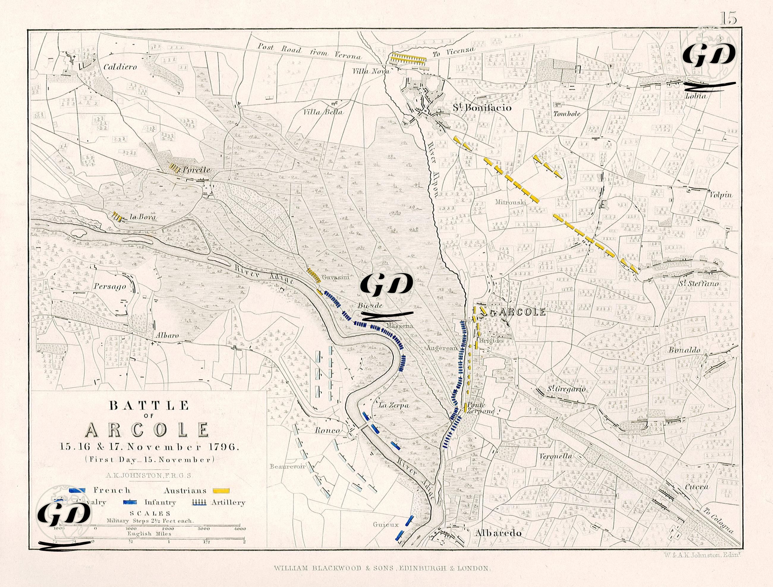
This map provides a detailed account of the military tactical situation on the first day (November 15) of the Battle of Arcole, one of the fiercest engagements of Napoleon Bonaparte's Italian Campaign, which took place between November 15–17, 1796. The French counterattack against the Austrian forces took place around the Arcole Bridge in Verona, northern Italy. The map focuses specifically on the first day of the battle, November 15, and graphically presents the disposition, advance, and engagement lines of the French (blue) and Austrian (yellow) forces. The town of Arcole, located in the center of the map, is located south of the Adige River. This town was the main focus of the battle, and the bridgehead and river line formed the critical axis of the battle. Marshes and wetlands to the east of the river hampered the French army's advance. The map shows these natural obstacles in detail, helping us understand why the battle became a "challenging river crossing and bridge battle." French troops are shown on the map in three main categories: infantry (filled blue rectangles), cavalry (half-filled blue rectangles), and artillery (arrows). Napoleon's army advanced north along the river from the town of Ronco on the first day. The map shows how the troops leaving Ronco deployed northward. The concentration of French troops around Bionde is particularly striking. The French army made a significant effort to cross the Arcole Bridge and establish a firm position on the opposite bank. Heavy losses were incurred during this crossing, and Napoleon personally took the standard and led his troops towards the bridge. The Austrians established a defensive line along the northeast-south line on the map, parallel to the eastern bank of the Adige. The most critical defensive line was east of Arcole, around St. Bonifacio, Porcile, and la Bova. The Austrian troops, shown with yellow arrows on the map, had support lines coming from Verona. This was intended both to block the river crossing and to trap the French army in the swamp. The St. Bonifacio line, in particular, is clearly delineated on the map, and it shows Austrian troops holding on to this area. This line was the main line of resistance preventing the French from expanding northward. The map clearly demonstrates that the battle revolved around a river crossing and control of the bridge. As Napoleon attempted to advance his army towards the Austrian lines via Arcole, he launched concentrated attacks in limited areas, as the marshy terrain was impossible to cross directly. The French launched repeated attacks on the bridgehead, failing on the first day, but the pressure yielded results on the second and third days. The Arcole Bridge stands as a pivotal point between the two armies on the map. Napoleon's presence on the front lines during the fighting here is one of the events that makes this battle legendary. Furthermore, the Battle of Arcole is considered a significant turning point, where Napoleon demonstrated his tactical genius and halted the Austrian advance into northern Italy.