GRAVÜR DÜNYASI
Digital Engraving Library
| Artist | Alexander Keith Johnston (1804-1871) |
| Engraver | William Johnston (1802-1888) |
| Date | 1848 |
| Technique | Steel Engraving-Original Hand Colored |
| Category | Maps |
| Source | Atlas Alison's History Of Europe By Alexander Keith Johnston - William Blackwood & Sons, Edinburgh & London |
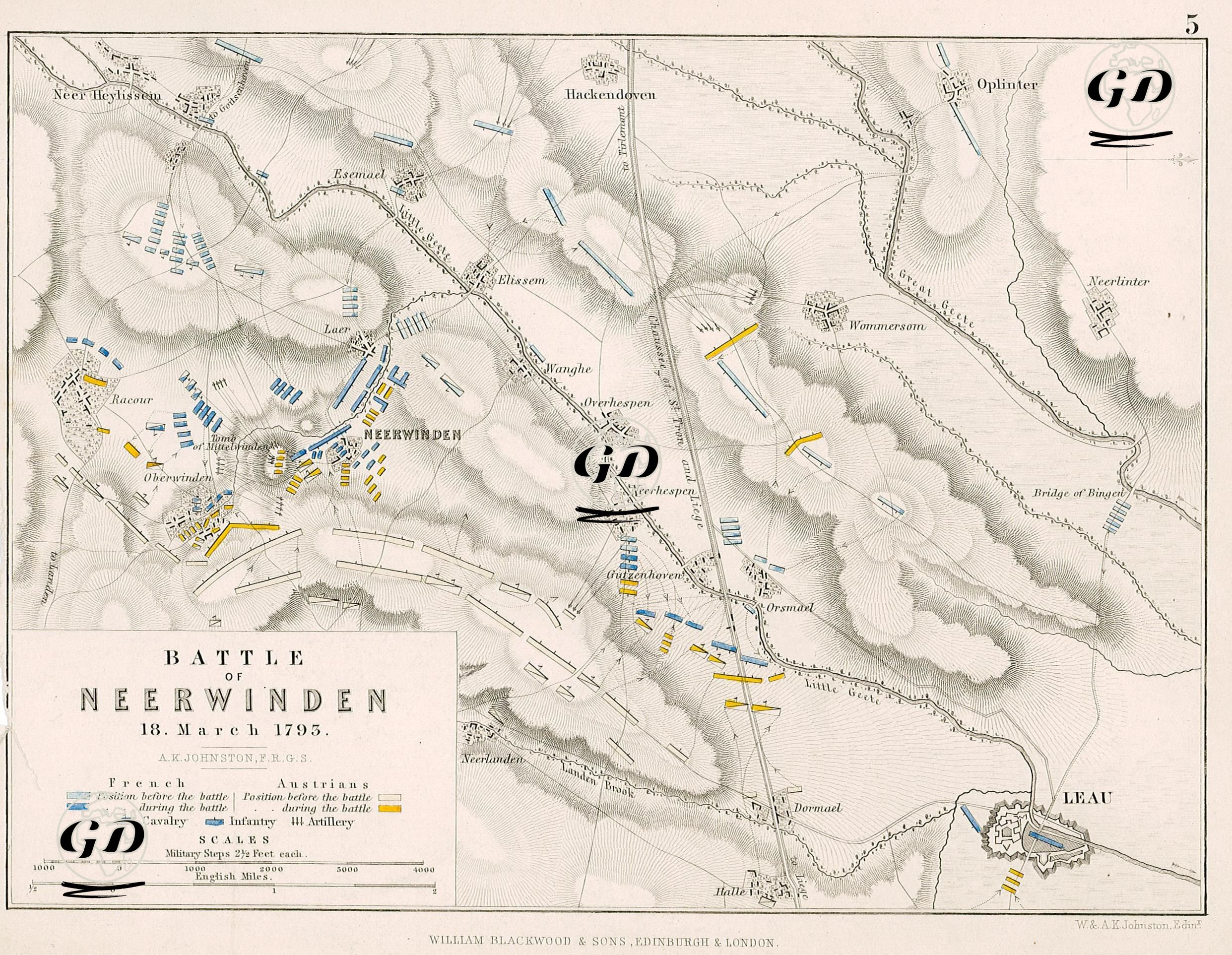
This detailed map of the Battle of Neerwinden, which took place on March 18, 1793, carefully depicts the tactical terrain and troop movements of the fighting between the French Republican Army and the Austrian Imperial forces. Blue and yellow represent French and Austrian units, respectively, while lighter shades indicate pre-battle positions and darker shades indicate positions during the battle. Unit types are identified by symbols: blue rectangles represent infantry, half-blue rectangles represent cavalry, and a triple arrow indicates artillery. Neerwinden, located in the Brabant region, is a key crossing point near the French-Belgian border. Villages such as Racour, Oberwinden, Neerhespen, and Elixem, featured on the map, were both focal points of the fighting and areas where the armies maneuvered. The town of Leau (Zoutleeuw), located in the southeast, played a key role in the Austrian army's logistical connections and line of retreat. The French were deployed along a line running north to south, positioned around Racour, Oberwinden, and Neerwinden. The Austrians, on the other hand, concentrated along a line running east to west, particularly around Wommersom, Elixem, and Oplinter. During the battle, the French troops took up defensive positions around Neerwinden and Neerhespen, while the Austrian army launched a three-pronged encirclement maneuver. The Austrian advance from the southeast, in particular, via Dornald, Little Geet, and Orsmard, arcing towards Neerwinden, highlights the strategic maneuver that determined the course of the battle. The artillery units positioned around Neerwinden provided both defensive and offensive support. The artillery line between Elixem and Neerhespen, in particular, accelerated the French withdrawal. The roads and bridging points, such as the "Bridge of Bingel," shown on the map indicate supply and retreat routes. The road running from Neerwinden towards Leau, in particular, served as the Austrian army's line of advance after the battle. Topographic lines on the map highlight the hilly areas where the armies were positioned. This height advantage, in particular, provided the Austrian army with maneuver and fire superiority. The Battle of Neerwinden was one of the first major defeats suffered by the Republican army after the French Revolution against Austria. Although the French army, under the command of General Charles Dumouriez, initially advanced into Belgium, it was repulsed by the Austrian Archduke's strategic counteroffensive. This battle forced Dumouriez to break with the Republic and flee, changing the course of the war.