GRAVÜR DÜNYASI
Digital Engraving Library
| Engraver | W.Hn |
| Date | 1788 |
| Technique | Copper Engraving |
| Category | Maps |
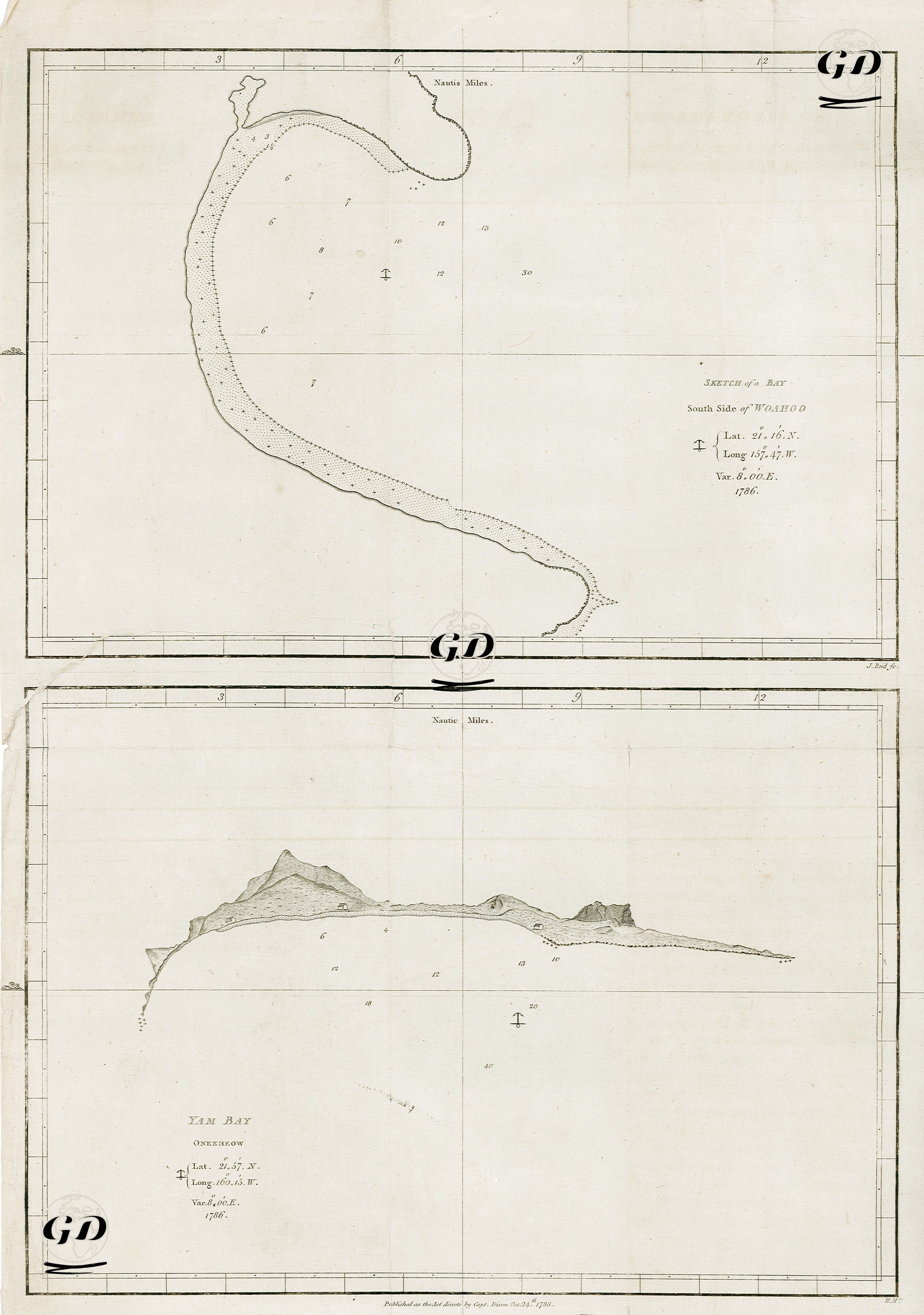
| Source | A Voyage Round The World, But More Particularly to The North-West Coast of America, Performed in 1785, 1786, 1787 and 1788, in the King George and Queen Charlotte, Captains Portlock and Dixon - Published As The Act Directs By Cap. Dixon, Oct. 24 1788 |
These two separate engraved maps contain detailed topographic and nautical information for two different island and bay regions in the Pacific Ocean. The upper map is titled "Sketch of a Bay / South Side of Woahoo" (Waikiki Bay, south of Oʻahu Island), while the lower one is titled "Yam Bay / Oneehow" (Yam Bay, Niʻihau Island). Both maps were drawn using a compass and include navigational information such as latitude and longitude, depth measurements (soundings), and magnetic variation. Furthermore, coastlines and topographic prominences are depicted with clear lines and shading, consistent with contemporary cartography. The upper map of Oʻahu, particularly on the south coast where Honolulu is located today, is one of the earliest examples of natural bays documented by European exploration in the 18th century. The latitude of 21°16′N and longitude of 157°47′W confirm that the map is within the borders of present-day Hawaii. Sea depths generally range from 6 to 12 fathoms. This map is one of the first British charts to document the navigability of the south coast of Oʻahu in 1786. The map below, Yam Bay, shows the area known as "Oneehow," located on the east coast of Niʻihau Island in the Hawaiian Archipelago. Located at latitude 21°53′N and longitude 160°15′W, this map details the island's rugged coastlines and sea depths (20 to 40 fathoms). The coastal profile (especially the mountainous areas) is depicted in slight perspective, making it a classic "coastal view" engraving. These engravings were prepared and published for George Dixon's book "A Voyage Round the World." The book documents the results of Dixon and Nathaniel Portlock's Royal Charter Exploration of the American Northwest and the Pacific from 1785 to 1788. The maps were produced for both maritime purposes and as a record of geographical and commercial discoveries. The British navy's strategic interest in the North Pacific and the Hawaiian Islands, in particular, was documented by such maps, creating the Western world's first accurate visual representations of these regions