GRAVÜR DÜNYASI
Digital Engraving Library
| Date | 1877 |
| Technique | Woodblock Engraving (Newspaper-Text on Reverse) |
| Category | Maps |
| Source | The İllustrated London News (September 22 1877-Page 284) |
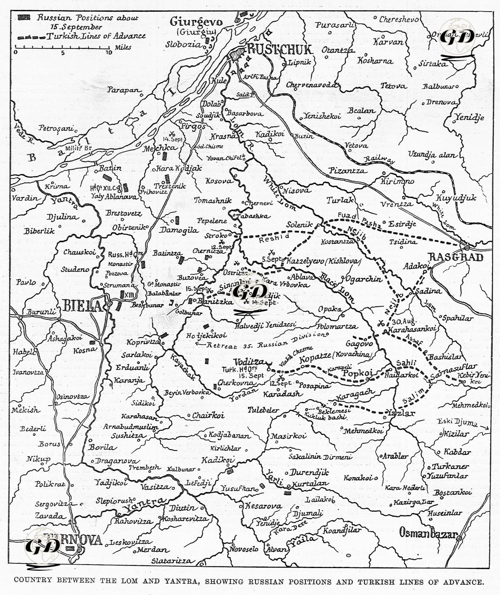
The map and news text published in The Illustrated London News on September 22, 1877 is a visual and written source documenting the Battle of Karahasanköy, one of the critical stages of the 1877 Ottoman-Russian War, in geographical and tactical detail. The map shows the counter-attack carried out by the Ottoman forces under the command of Mehmet Ali Pasha in the region extending from the Lom River to the Yantra Valley and the military movements experienced within this scope. It also topographically reflects the positions recently occupied by the Russian army and the retreat routes against the Ottoman advance. The symbols on the map indicate the advances and positions of the Russian and Ottoman forces between August 30 and September 15, 1877. The square symbols indicate the Russian troops, and the broken lines indicate the Ottoman advance line (especially the Halavorköy–Popkoi–Kovachina route). The troops under the command of Midhat Ali Pasha, the Commander-in-Chief of the Ottoman army, formed a defensive line in the area between the Lom River and Yantra, especially in the triangle of Rusçuk (Ruschuk), Biela (Beyaz), and Tirnova (Tırnova). The map shows in particular that the 13th Russian Corps was positioned in and around Biela, the 11th Corps to the northwest of Tirnova, and the 4th Corps to the east of Tirnova. At the same time, the Popkoi (Popköy), Halavorköy (Halavorka), and Karaagaç (Karagach) line, which was the target of the forward operation carried out by the Ottoman troops around September 15, is clearly shown on the map. The news text conveys the course of the clashes that took place in the Karahasan Village region on August 30, 1877. Accordingly, on August 30, 1877, the Ottoman army organized a raid against the Russian positions on the Popkoi and Halavorköy line; During this operation, Ottoman troops advanced through narrow passes and forested areas under heavy artillery support. The simultaneous advance plan of the Ottoman divisions under the command of Necip Pasha and Salih Pasha from two wings through Adaköy and Yeniköy is depicted on the map as two axes. The aim of the attack was to break the lines formed by the Russians along the Lom River and to weaken the Danube defenses by pushing them back from the direction of Rusçuk. As stated in the text, although the Ottoman attack was successful, the batteries and artillery units of the Russians in the high positions seriously slowed the Ottoman advance and prevented the attack from being expanded. In addition, it was reported in the continuation of the news that the Ottoman troops forced the Russian troops around Karahasan Village to temporarily retreat with the surprise advances made by night marches along this line. However, it is stated that the Russian forces quickly counterattacked with reserve troops and maintained their positions.