GRAVÜR DÜNYASI
Digital Engraving Library
| Engraver | Ernst George Ravenstein (1834-1913) |
| Date | 1877 |
| Technique | Woodblock Engraving (Newspaper-Text on Reverse) |
| Category | Maps |
| Source | The İllustrated London News (September 15 1877-Page 262) |
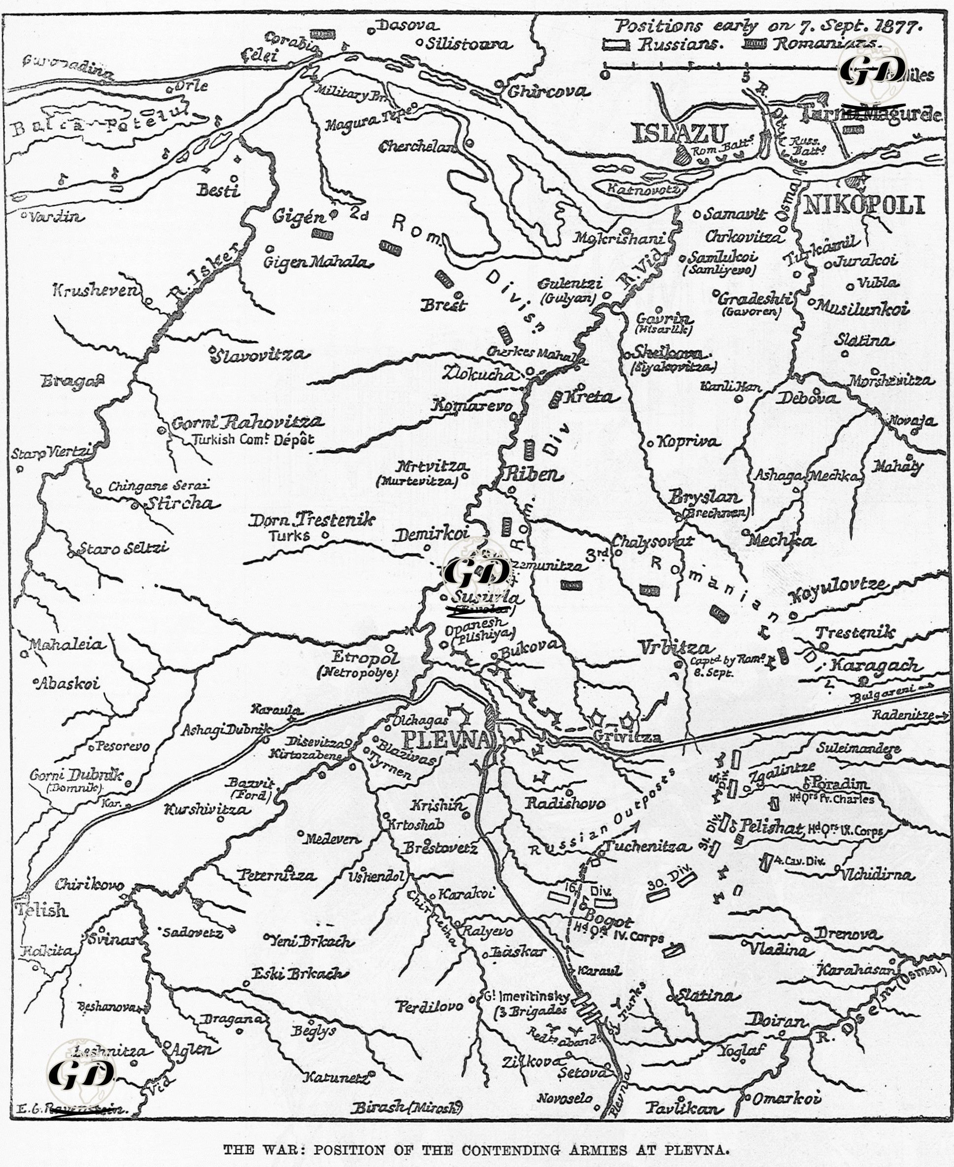
This map and report, published in The Illustrated London News on September 15, 1877, show in detail the location of Russian, Romanian and Ottoman forces and how strategic geography was used during the Siege of Plevna as of September 7, 1877. The report provides detailed information, especially about the geographical structure, transportation routes and military deployments around Plevna. The fortifications of the Ottoman forces and the positions of the Russian and Romanian troops are reported based on sketches and testimonies obtained from the field. In the text, the plateau region extending between the Osma and Vid rivers stands out as the strategic area that will witness the decisive battles of the war. The region described in the text is a plateau bounded by the Vid River to the west, the Osma River to the east, the Danube River to the north and the Kodji Balkans (today's Balkan Mountains) to the south. This land, approximately 150 versts (160 km) long, is characterized by steep valleys and dense village settlements. The Vid River is formed by the confluence of the Kara Vid and Ak Vid branches; it flows northward and is fed by numerous streams. The Osma River, on the other hand, starts from Trojana and reaches the Danube via Lovcha (today's Lovech); it draws a wide circular route with its meandering structure, the center of which is Plevna. These geographical features are of great importance in terms of both logistics and defense. The text indicates the existence of six main roads leading to Plevna and how these formed strategic crossing points in the Osma-Vid basin. These roads witnessed fierce struggles between the Ottoman supply routes and the advance routes of the Russian-Romanian alliance. In particular, villages and towns such as Lovcha, Trojana, Poradim, Radenitza, Gravitza, Neredintsa, Zerkalovitsa and Tristenik were prominent settlements in the clashes on these routes. The Habar text provides a detailed account of the quantitative structure of the army of the Russian-Romanian allied forces stationed around Plevna. Accordingly, the allied forces stationed on the front were composed of the 16th and 30th Infantry Divisions and the 4th Cavalry Division of the 4th Russian Corps under the command of General Krylof, the 5th and 31st Infantry Divisions and the 9th Cavalry Division of the 9th Corps under the command of Baron Krüdener, and various infantry units under Prince Imeritinsky (the positions of the Russian and Romanian units are shown in detail on the map as of September 7, 1877), and at least three Romanian divisions were also serving on this front. The total combat power of this combined force was estimated at approximately 91,000 riflemen (bayonet infantry), 13,000 cavalrymen, and 250 field guns. Despite this numerical superiority, the defensive lines established by the Ottoman forces under the command of Osman Pasha around Plevne were constructed by skillfully taking advantage of the geographical structure of the region. The irregular plateau-shaped terrain between the Osma and Vid rivers, with its steep passes, valleys and river branches, provides both a natural defense area and the opportunity for strategic positioning of artillery batteries. With the support of heavy siege artillery, especially around the villages of Zgalintze and Pelishat, the Ottoman forces took control of both the front line and the logistics routes in the rear area. These fortified Ottoman defense lines stopped the advance of the numerically superior allied forces and made Plevne a point of resistance on the strongest supply and advance line coming from the Black Sea.