GRAVÜR DÜNYASI
Digital Engraving Library
| Date | 1877 |
| Technique | Woodblock Engraving (Newspaper-Text on Reverse) |
| Category | Maps |
| Source | The İllustrated London News (July 28 1877-Page 91) |
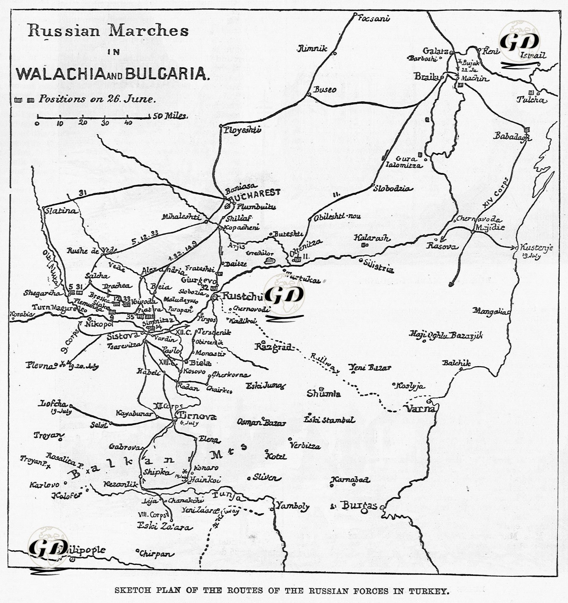
This map and accompanying news article, published in The Illustrated London News on 28 July 1877, provides a detailed picture of the developments on the Balkan Front of the 1877–1878 Ottoman–Russian War. The map shows the Ottoman defensive lines along the Danube, the advance of the Russian armies from the north of the Danube to the south, towards the Balkan Mountains and the Rumelian plains, and the routes they used during this advance. The map shows the positions of the central units of Grand Duke Nicholas, who crossed the Danube at Simnitza on 26 June, and particularly highlights the river crossings along the Simnitza–Sistova line. The 14th Corps, forming the right wing, crossed the Danube from Braila or Galatz and advanced southwards towards Medjidieh (Mecidiye) and Kustendje (Constanța) via Dobruja. The 12th and 13th army corps, under the direct command of the Commander-in-Chief, advanced from Sistova along the Yantra River towards Tirnova (today's Veliko Tarnovo), and this city was captured on July 6. The vanguard units of the 8th Corps crossed the Balkans via Hainköy and Shipka Pass and reached the Tundja Valley, Kazanlık and Stara Zagora. At the same time, it is stated that the 14th Corps descended southwards via Braila and Galatz towards Medjidieh and Kustendje, while the 9th Corps captured Nikopol Castle and secured the third crossing point on the Danube. An attempt was made to build a third bridge over the Danube here, but it is stated that this advance towards the Plevne line encountered difficulties and that the Ottoman force under the command of Osman Pasha posed a threat to the Russian right flank around Plevne and inflicted significant damage. Some units of the Russian army were tasked with the Siege of Ruscuk (Ruse), while others were tasked with the Siege of Silistre. Operations against these Danube fortresses occupied a total force of approximately 100,000 men, more than half of the Russian army. The remaining Russian forces were tasked with securing the lines of communication in Central Bulgaria, capturing the Balkan passes, and ultimately conquering Rumelia and advancing towards Edirne. However, these units were not strong enough. The left flank is under threat from the solid defensive line in Shumen, where the Turkish army has taken refuge. Shumen has a solid fortress with connections to Varna, and the naval support of the Ottoman navy strengthens the hand of the Turkish army. The news emphasizes that the Ottoman army should retreat to the south of the Balkans, hold the mountain passes and delay the Russians as much as possible on the plains in the north. It also states that Shumen constitutes an important base for the rear flank of the Turkish army due to its solid fortifications and connections to Varna. It emphasizes that the Danube River is an obstacle that can be passed in a short time rather than a natural defensive line, and that the Ottoman defense should be concentrated in the Balkan passes in real terms. In conclusion, this map and text reveal the military importance of the strategic settlements and transit lines along the Danube in the first months of the war, also known as the War of 93, and the Russians' multi-faceted advance strategy, while also showing how the Ottoman side tried to use geographical advantages to stop this advance. Particularly Shumen, Pleven and the Balkan passes are highlighted as critical points that will determine the fate of the war.