GRAVÜR DÜNYASI
Digital Engraving Library
| Date | 1720 |
| Technique | Copper Engraving |
| Category | Maps |
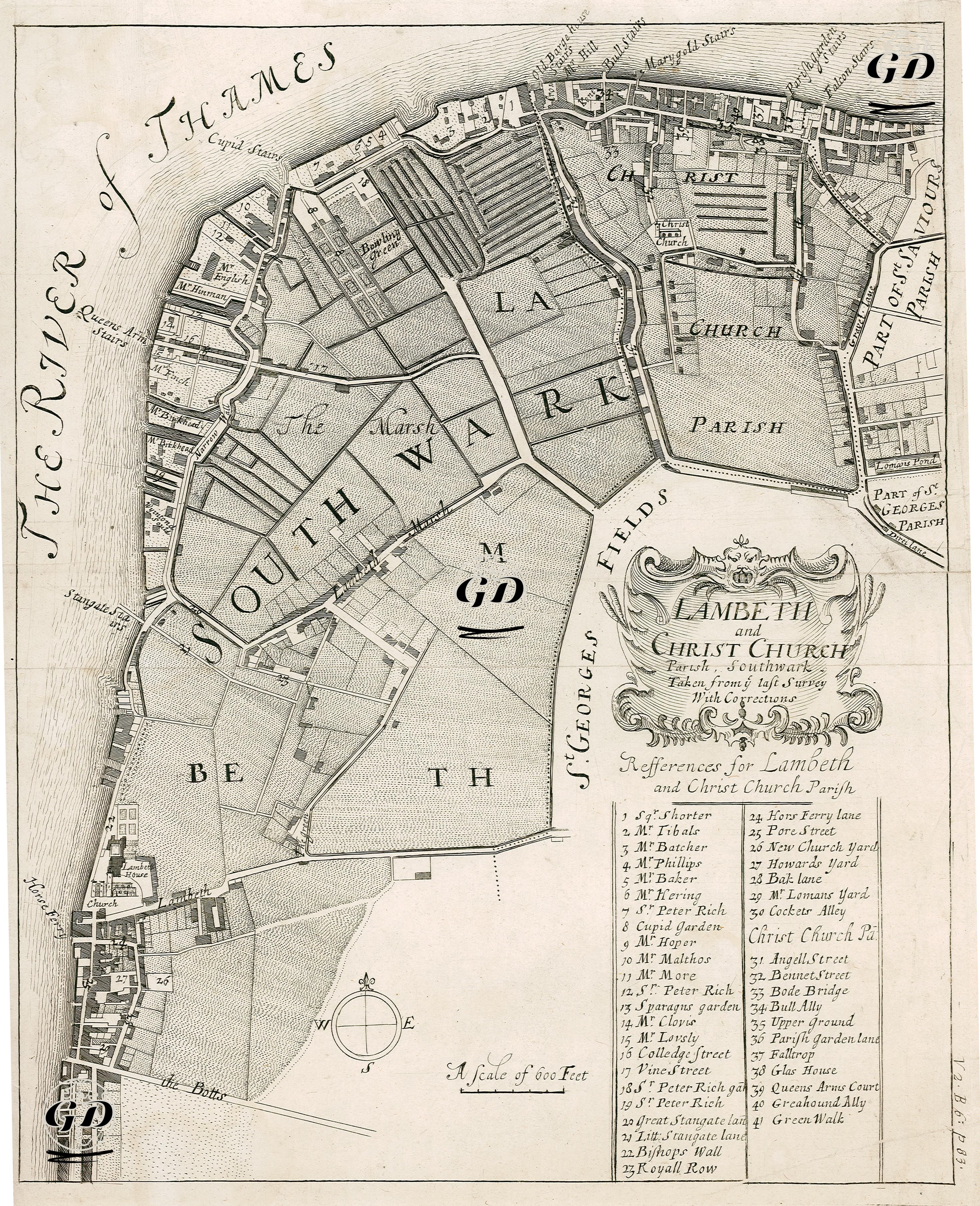
This map dated 1720 depicts both the local settlement structure and social property relations of the Southwark, Lambeth, and Christ Church Parish districts of London's South End at the beginning of the 18th century. Located on the south bank of the River Thames, this map illuminates the early stages of urban development. The map documents the administrative, social, and residential structure of London at the beginning of the 18th century. Its title, "Lambeth and Christ Church Parish, Southwark," emphasizes the parish administrative structure of the area, centered around the church. This period marked a period of strong church influence in civil administration in England. The map documents a period when industrialization and urbanization were still limited, showing open spaces such as St. George's Fields and lands such as Southwark Marsh (marsh/public pastureland) that had not yet been fully developed. The reference box in the lower right corner of the map lists the names of homeowners or businesses in the Lambeth and Christ Church Parish areas (for example: “Mr. Shorter”, “Mr. Phillips”, “Mr. Maltes”, “Mr. Lumus Yard”, etc.). This is significant for its depiction of both social class distribution and individual property ownership. The map also provides rich insights into how daily life was organized in early 18th-century London, detailing parochial boundaries, churchyards, marshland areas, houses, inns, streets, and ferry routes (wharfs). Furthermore, the map represents a rural-urban transition on London's south bank. One of the most striking elements is the large font of the River Thames on its left bank: "THE RIVER OF THAMES." The wharves and docks along the river indicate the region's role in trade and transportation. Inns and public buildings such as the Queen Anne's Arms and the Dog and Duck represent both centers of urban social life and residential/commercial centers. The map's Compass Rose and 600-foot scale allow for precise determination of distances and directions. Furthermore, the map's title frame, crafted in a typical 18th-century style with baroque ornamentation, reflects the artistic and aesthetic tastes of the period, as well as cartographically. Located on the banks of the Thames River, at a time when the urban fabric was not yet fully formed, the church-centered organization of neighborhoods, the arrangement of houses surrounded by fields, and the listing of property owners make the map a resource for both historical and geographical analysis.