GRAVÜR DÜNYASI
Digital Engraving Library
| Engraver | William Johnston (1802-1888) - Alexander Keith Johnston (1804-1871) |
| Date | 1856 |
| Technique | Lithography-Colored |
| Category | Maps |
| Source | Pictorial History Of The Russian War 1854-5-6 - W.R.Chambers London & Edinburgh -Printed in Colours by Schenck & McFarlane, Edinburgh |
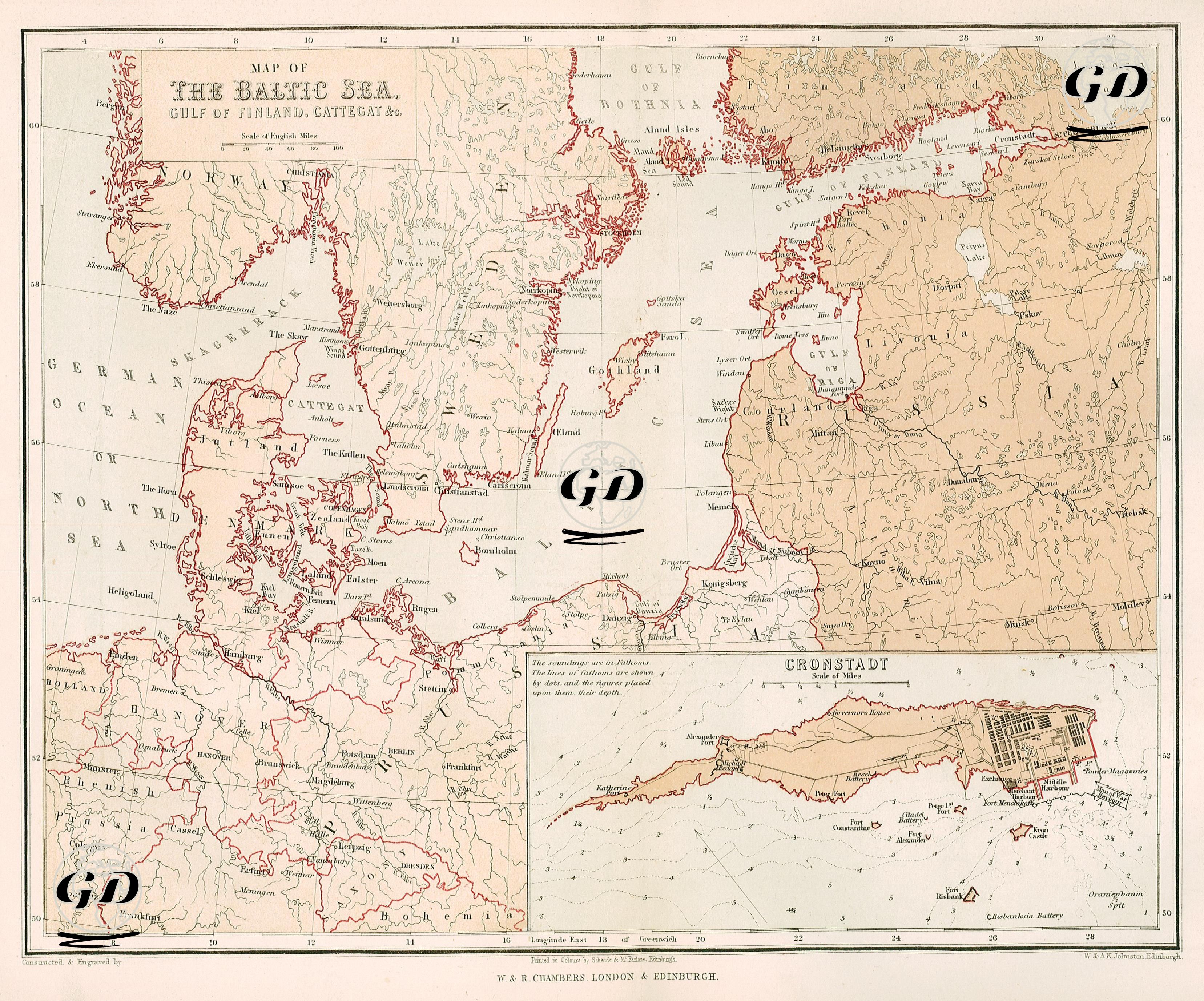
The map, dated 1856, shows the Baltic Sea, the Gulf of Finland, the Kattegat and surrounding coastal areas in detail. The map includes not only the general geography but also strategic points that emphasize the importance of the Baltic Front during the Crimean War. The countries bordering the Baltic Sea (Sweden, Norway, Denmark, Germany, Prussia, Russia and Finland) are shown in detail in the upper part of the map, while the inset in the lower corner shows Kronstadt, the naval defense fortress of St. Petersburg and the center of the Baltic Fleet. The larger part of the map shows the Danish strait system (Kattegat, Skagerrak), the northern port cities of Germany, especially Kiel and Lübeck, and the coastal cities along the Gulf of Finland all the way to St. Petersburg in detail. Important Baltic port cities such as Riga, Reval (Tallinn), Viborg and Helsingfors (Helsinki) are marked, and the defense lines and maritime traffic routes on the western border of the Russian Empire are highlighted. This area was the second important maritime front of the war after the Black Sea. In particular, during the Baltic Campaigns of the British and French navies in 1854 and 1855, bases such as Kronstadt and Sveaborg (today Suomenlinna) were targeted, but could not be taken due to the strong fortifications. The close-up of Kronstadt in the lower part of the map shows the defense systems of this island, which is located just west of Saint Petersburg and was the main base of the Baltic Fleet. Kronstadt served as the main base of the Russian Navy from the time of Tsar Peter I and was the most strategic point against attacks by Western navies during the Crimean War. Here, military and logistic structures such as the Governor's Mansion, Naval Arsenal, Shipyards, Fort Alexander, Fort Constantine, Batteries, and the Lighthouse are detailed. This engineering drawing clearly demonstrates how difficult it is to enter the city from the sea. The map shows the borders of the countries with color distinctions, the coastlines in red, and also shows the sea depths and anchorage areas. The map shows that the war was not limited to the Crimean peninsula, and that the ports and bases in the northwest of Russia also played important roles in the war.