GRAVÜR DÜNYASI
Digital Engraving Library
| Date | 1830's |
| Technique | Copper Engraving |
| Category | Maps |
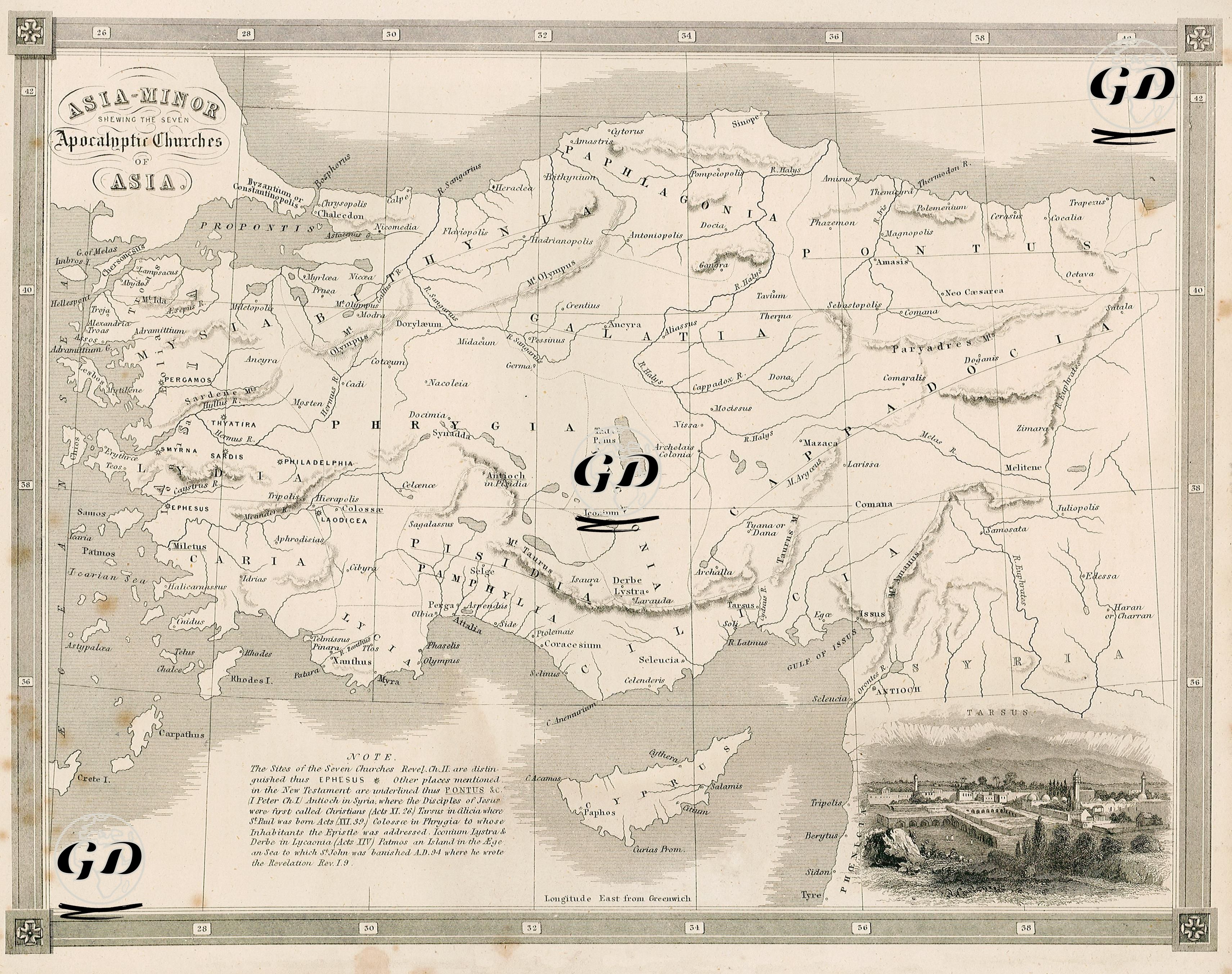
This map, titled "Asia Minor Shewing the Seven Apocalyptic Churches of Asia," is a cartographic and theological document prepared in the 1830s. Focusing specifically on Revelation, the final book of the New Testament, the map geographically identifies the cities where the letters sent by Jesus Christ through St. John to the seven churches in Asia were addressed. The "NOTE" legend at the bottom left of the map clearly indicates that these churches, located in what is today Western Anatolia, are marked with a star symbol. Furthermore, each of these cities belongs to the early Christian communities that received the seven letters revealed by Jesus to St. John while on the Island of Patmos. The map shows the cities containing these churches under their Greco-Roman names: Ephesus (Efes), Smyrna (Izmir), Pergamos (Bergama), Thyatira (Akhisar), Sardis (Sart), Philadelphia (Alaşehir), and Laodicea (near Goncalı/Denizli). The map's legend highlights not only these churches but also other important sites mentioned in the New Testament. For example, PONTUS is underlined on the map, directly linking these locations to New Testament texts. The explanation states that Antioch in Syria is where the name "Christian" was first given to Jesus' followers, according to Acts 11:26. Tarsus is highlighted as the birthplace of St. Paul, according to Acts 22:39, and is also visually depicted in a small engraving in the lower right corner of the map. This image is not only a geographical detail but also a reference to St. Paul's theological and missionary origins. The map also marks Colossae in Phrygia as the addressee of the Letter to the Colossians. Iconium, Lystra, and Derbe in Lycaonia are cited as cities visited by St. Paul during his early missionary journeys, with reference to Acts 14. The island of Patmos is specifically mentioned as the place where St. John was exiled in 94 AD and wrote the Book of Revelation, emphasizing its centrality in the narrative of the Apocalyptic churches. The city names on the map present a multilayered narrative, combining both geographical designations from the Greco-Roman period and symbolic meanings within early Christian history. Major regions of ancient Anatolia—such as Lydia, Phrygia, Galatia, Cappadocia, Pisidia, and Pamphylia—are shown along with their borders, thus making the map not only a theological tool but also a resource for classical history and archaeology.