GRAVÜR DÜNYASI
Digital Engraving Library
| Artist | John Rapkin(1815-1876) |
| Engraver | John Rapkin (1815-1876) |
| Date | 1860 |
| Technique | Steel Engraving |
| Category | Maps |
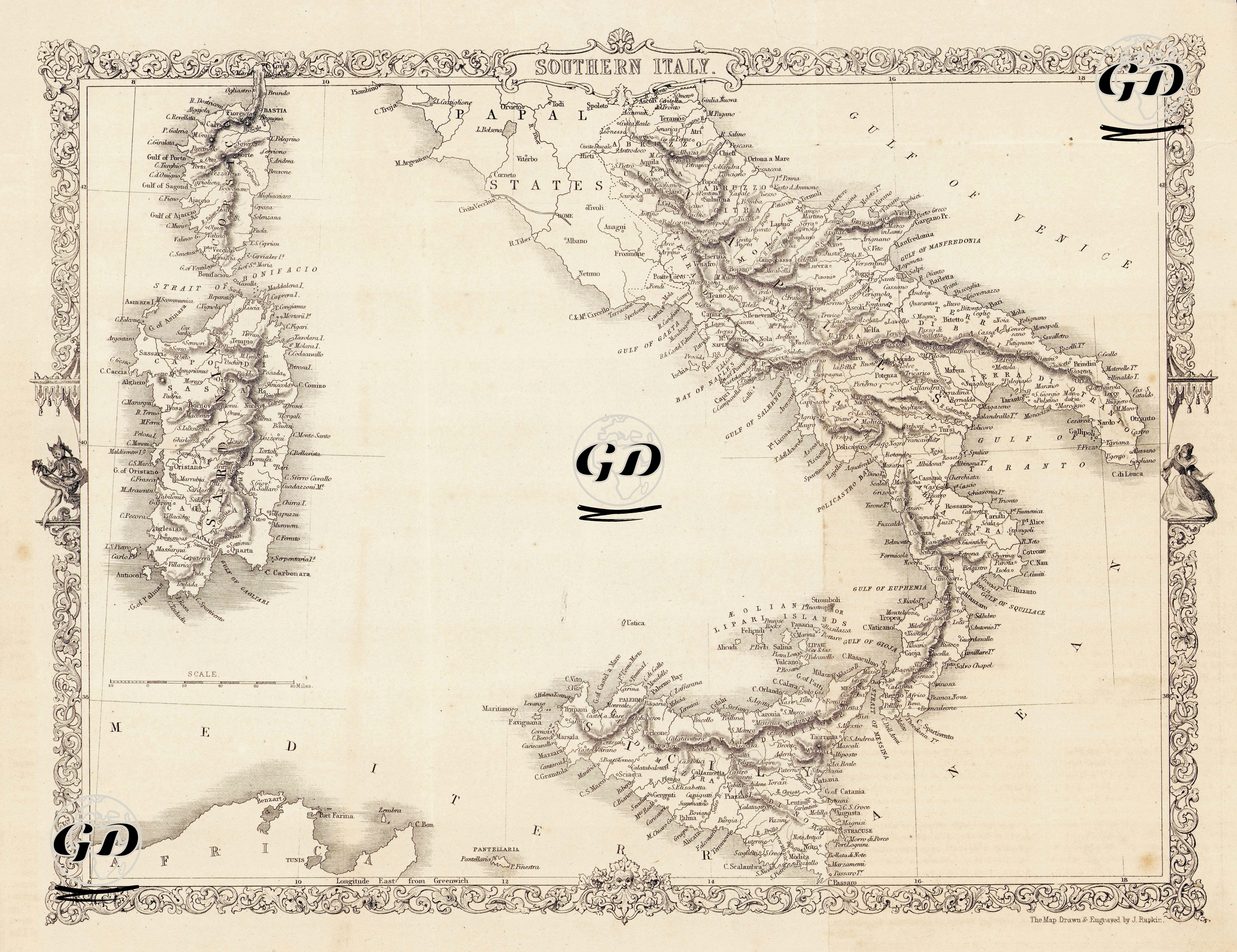
This detailed map, drawn in 1860, encompasses the southern part of the Italian Peninsula, the islands of Sicily and Sardinia, and the opposite coast of North Africa. It reflects a transitional period when Italy was not yet fully unified, dominated by regional kingdoms and religious authorities. The Naples region at the center of the map was known at the time as the "Kingdom of the Two Sicilies," encompassing both the southern Italian peninsula and the island of Sicily. Its capital was Naples, ruled by the Bourbon dynasty. In 1860, the kingdom was overthrown by the "Expedition of the Thousand" (Spedizione dei Mille) led by Giuseppe Garibaldi, and incorporated into the Kingdom of Sardinia-Piemonte. The island of Sicily, depicted in detail on the map, stands out as a region of historical, economic and strategic importance, with its important centers such as Mount Etna, Palermo, Messina and Syracusa. Sardinia, located in the northwest of the map, is shown as a separate island and is part of the Kingdom of Sardinia-Piemonte, which unified Italy in 1860. This kingdom, centered in Turin, is the founding power of modern Italy. The Papal States in central Italy are detailed on the map along with Rome and its surrounding area. At that time, they were still under the political dominion of the Catholic Church, with the Pope holding both religious and temporal authority. The Papal States were largely annexed by Piedmont in the 1860s, but Rome only joined the union in 1870. Another striking element on the map is the detailed depiction of the region's ports, gulfs, and straits, along with important maritime terms such as "Gulf of Venice," "Gulf of Taranto," "Gulf of Naples," and "Strait of Messina." Additionally, the map's lower left corner features information about the Tunisian coast, or northern Africa. The word "Africa" and the region of Carthage are mentioned, indicating Italy's strategic position within the Mediterranean. Furthermore, the map's aesthetically pleasing border, decorated with classical lines, is one of the most elegant forms of map art in the 19th century. Furthermore, the upper and lower edges feature ornate borders, within which are figurative representations, particularly women dressed in classical mythology and heraldic symbols. This aesthetically pleasing frame of the map is one of the most elegant forms of map art in the 19th century.